![](/images/other/stat-length.png)
![Randonnée A pied Blankenheim - Wacholderweg - Photo](https://media.geolcdn.com/t/1900/400/01cd7a12-e0de-428d-9b36-030f1806b10d.jpeg&format=pjpeg&maxdim=2)
Wacholderweg
SityTrail - itinéraires balisés pédestres
Tous les sentiers balisés d’Europe GUIDE+
![Longueur](/images/other/stat-length.png)
Longueur
10,4 km
![Altitude max](https://static1.geolcdn.com/siteimages/upload/files/1508320355ic_sort_altitude_max_24dp.png)
Altitude max
568 m
![Dénivelé positif](https://static1.geolcdn.com/siteimages/upload/files/1508320355ic_sort_den_pos_24dp.png)
Dénivelé positif
217 m
![Km-Effort](/images/other/stat-length.png)
Km-Effort
13,3 km
![Altitude min](https://static1.geolcdn.com/siteimages/upload/files/1508320355ic_sort_altitude_min_24dp.png)
Altitude min
452 m
![Dénivelé négatif](https://static1.geolcdn.com/siteimages/upload/files/1508320355ic_sort_den_neg_24dp.png)
Dénivelé négatif
220 m
![Boucle](https://static1.geolcdn.com/siteimages/upload/files/16400158638029165_repeat_loop_refresh_sync_direction_icon.png)
Boucle
Non
Balise
Date de création :
2022-02-11 15:17:29.889
Dernière modification :
2022-02-11 15:17:29.889
![A pied](https://static1.geolcdn.com/sitytour/trail-icons/100.png)
3h01
Difficulté : Facile
![Scannez ce code QR pour ouvrir la randonnée dans l'application SityTrail](https://capi.geolives.com/qq0zvz2zws4bq2lad0pu/sitytour/trails/3094214/qr.png?size=200)
Application GPS de randonnée GRATUITE
À propos
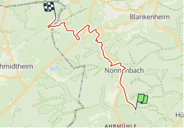
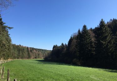
Randonnée A pied de 10,4 km à découvrir à Rhénanie-du-Nord-Westphalie, Euskirchen, Blankenheim. Cette randonnée est proposée par SityTrail - itinéraires balisés pédestres.
Description
Randonnée créée par Eifelverein.
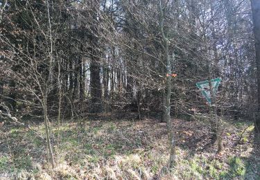
Die Farbe des W ist schwarz, nicht rot, geändert.
Symbole: Schwarzes W auf weißem Grund
Localisation
Pays :
Allemagne
Région :
Rhénanie-du-Nord-Westphalie
Département/Province :
Euskirchen
Commune :
Blankenheim
Localité :
Unknown
Départ:(Dec)
Départ:(UTM)
332363 ; 5585415 (32U) N.
Commentaires
Randonnées à proximité
![Randonnée A pied Blankenheim - EifelSchleife Über den Brotpfad - Photo](https://media.geolcdn.com/t/375/260/da05d5b2-417a-48c2-836f-892e153523cc.jpeg&format=jpg&maxdim=2)
![A pied A pied](https://static1.geolcdn.com/sitytour/trail-icons/100.png)
EifelSchleife Über den Brotpfad
A pied
Facile
Blankenheim,
Rhénanie-du-Nord-Westphalie,
Euskirchen,
Allemagne
![](/images/other/stat-length.png)
12,2 km | 15,6 km-effort
3h 33min
![](https://static1.geolcdn.com/siteimages/upload/files/16400158638029165_repeat_loop_refresh_sync_direction_icon.png)
Oui
![Randonnée A pied Blankenheim - EifelSpur Toscana der Eifel - Photo](https://media.geolcdn.com/t/375/260/9954d448-1f53-496a-a26c-bd8e38d24ff2.jpeg&format=jpg&maxdim=2)
![A pied A pied](https://static1.geolcdn.com/sitytour/trail-icons/100.png)
EifelSpur Toscana der Eifel
A pied
Moyen
Blankenheim,
Rhénanie-du-Nord-Westphalie,
Euskirchen,
Allemagne
![](/images/other/stat-length.png)
15,3 km | 21 km-effort
4h 42min
![](https://static1.geolcdn.com/siteimages/upload/files/16400158638029165_repeat_loop_refresh_sync_direction_icon.png)
Oui
![Randonnée A pied Blankenheim - Eifelschleife Wo Bäche verschwinden - Photo](https://media.geolcdn.com/t/375/260/4f4ac008-da75-40e6-9c7c-c2022fc315f6.jpeg&format=jpg&maxdim=2)
![A pied A pied](https://static1.geolcdn.com/sitytour/trail-icons/100.png)
Eifelschleife Wo Bäche verschwinden
A pied
Facile
Blankenheim,
Rhénanie-du-Nord-Westphalie,
Euskirchen,
Allemagne
![](/images/other/stat-length.png)
10,4 km | 13 km-effort
2h 57min
![](https://static1.geolcdn.com/siteimages/upload/files/16400158638029165_repeat_loop_refresh_sync_direction_icon.png)
Oui
![Randonnée Vélo Blankenheim - f-duitsland-eifelroute - Photo](https://media.geolcdn.com/t/375/260/ext.jpg?maxdim=2&url=https%3A%2F%2Fstatic1.geolcdn.com%2Fsiteimages%2Fupload%2Ffiles%2F1524743154velo.jpg)
![Vélo Vélo](https://static1.geolcdn.com/sitytour/trail-icons/200.png)
f-duitsland-eifelroute
Vélo
Très facile
Blankenheim,
Rhénanie-du-Nord-Westphalie,
Euskirchen,
Allemagne
![](/images/other/stat-length.png)
284 km | 349 km-effort
Inconnu
![](https://static1.geolcdn.com/siteimages/upload/files/16400158638029165_repeat_loop_refresh_sync_direction_icon.png)
Oui
![Randonnée Vélo Blankenheim - Duitsland - Rondje Blankenheim - Photo](https://media.geolcdn.com/t/375/260/ext.jpg?maxdim=2&url=https%3A%2F%2Fstatic1.geolcdn.com%2Fsiteimages%2Fupload%2Ffiles%2F1524743154velo.jpg)
![Vélo Vélo](https://static1.geolcdn.com/sitytour/trail-icons/200.png)
Duitsland - Rondje Blankenheim
Vélo
Très facile
Blankenheim,
Rhénanie-du-Nord-Westphalie,
Euskirchen,
Allemagne
![](/images/other/stat-length.png)
39 km | 48 km-effort
Inconnu
![](https://static1.geolcdn.com/siteimages/upload/files/16400158638029165_repeat_loop_refresh_sync_direction_icon.png)
Oui
![Randonnée Marche Blankenheim - Ahrsteig etappe 1 rondwandeling 22km. - Photo](https://media.geolcdn.com/t/375/260/ext.jpg?maxdim=2&url=https%3A%2F%2Fstatic1.geolcdn.com%2Fsiteimages%2Fupload%2Ffiles%2F1553511878bg_sport_marche.png)
![Marche Marche](https://static1.geolcdn.com/sitytour/trail-icons/101.png)
Ahrsteig etappe 1 rondwandeling 22km.
Marche
Moyen
Blankenheim,
Rhénanie-du-Nord-Westphalie,
Euskirchen,
Allemagne
![](/images/other/stat-length.png)
23 km | 30 km-effort
6h 25min
![](https://static1.geolcdn.com/siteimages/upload/files/16400158638029165_repeat_loop_refresh_sync_direction_icon.png)
Oui
![Randonnée Marche Wiesbaum - ESt-08 - Photo](https://media.geolcdn.com/t/375/260/ext.jpg?maxdim=2&url=https%3A%2F%2Fstatic1.geolcdn.com%2Fsiteimages%2Fupload%2Ffiles%2F1553511878bg_sport_marche.png)
![Marche Marche](https://static1.geolcdn.com/sitytour/trail-icons/101.png)
ESt-08
Marche
Moyen
Wiesbaum,
Rhénanie-Palatinat,
Landkreis Vulkaneifel,
Allemagne
![](/images/other/stat-length.png)
25 km | 33 km-effort
6h 53min
![](https://static1.geolcdn.com/siteimages/upload/files/16400158638029165_repeat_loop_refresh_sync_direction_icon.png)
Non
![Randonnée Marche Blankenheim - ESt-07 - Photo](https://media.geolcdn.com/t/375/260/ext.jpg?maxdim=2&url=https%3A%2F%2Fstatic1.geolcdn.com%2Fsiteimages%2Fupload%2Ffiles%2F1553511878bg_sport_marche.png)
![Marche Marche](https://static1.geolcdn.com/sitytour/trail-icons/101.png)
ESt-07
Marche
Moyen
Blankenheim,
Rhénanie-du-Nord-Westphalie,
Euskirchen,
Allemagne
![](/images/other/stat-length.png)
17,5 km | 23 km-effort
4h 53min
![](https://static1.geolcdn.com/siteimages/upload/files/16400158638029165_repeat_loop_refresh_sync_direction_icon.png)
Non
![Randonnée Autre activité Blankenheim - Duitsland - Eifelsteig 06: Ripsdorf - Kerpen - Photo](https://media.geolcdn.com/t/375/260/ext.jpg?maxdim=2&url=https%3A%2F%2Fstatic1.geolcdn.com%2Fsiteimages%2Fupload%2Ffiles%2F1545311037marcheuse_200dpi.jpg)
![Autre activité Autre activité](https://static1.geolcdn.com/sitytour/trail-icons/900.png)
Duitsland - Eifelsteig 06: Ripsdorf - Kerpen
Autre activité
Moyen
Blankenheim,
Rhénanie-du-Nord-Westphalie,
Euskirchen,
Allemagne
![](/images/other/stat-length.png)
27 km | 34 km-effort
7h 15min
![](https://static1.geolcdn.com/siteimages/upload/files/16400158638029165_repeat_loop_refresh_sync_direction_icon.png)
Non