Randonnée A pied Erndtebrück - Mäanderweg - Photo

Tous les sentiers balisés d’Europe GUIDE+

© OpenStreetMap contributors
Longueur
Longueur
27 km
Altitude max
Altitude max
624 m
Dénivelé positif
Dénivelé positif
629 m
Km-Effort
Km-Effort  
35 km
Altitude min
Altitude min
441 m
Dénivelé négatif
Dénivelé négatif
629 m
Boucle
Boucle
Oui
Balise
Balise
Date de création :
2022-02-11 15:17:09.868
Dernière modification :
2022-02-11 15:17:09.868

(0 Avis)

A pied
A pied
7h56
Difficulté : Difficile

Scannez ce code QR pour ouvrir la randonnée dans l'application SityTrail

Application GPS de randonnée GRATUITE

Logo SityTrail SityTrail

IGN / Instituts géographiques

Télécharger SityTrail sur l'App Store Télécharger SityTrail sur Google Play

Logo SityTrail SityTrail World

Le monde est à vous

Télécharger SityTrail sur l'App Store Télécharger SityTrail sur Google Play Télécharger SityTrail sur Huawei AppGallery

À propos

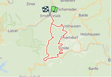
Randonnée A pied de 27 km à découvrir à Rhénanie-du-Nord-Westphalie, Kreis Siegen-Wittgenstein, Erndtebrück. Cette randonnée est proposée par SityTrail - itinéraires balisés pédestres.

Description

Randonnée créée par Toutistikverband Siegerland Wittgenstein e.V..

Teil der Wanderhöhepunkte links und rechts des Rothaarsteigs

Symbole: Hügelkette im Kreis

Profil altimétrique

Photos

Localisation

Pays :
Allemagne
Région :
Rhénanie-du-Nord-Westphalie
Département/Province :
Kreis Siegen-Wittgenstein
Commune :
Erndtebrück
Localité :
Unknown
Départ:(UTM)
447793 ; 5648837 (32U) N.

Randonnées à proximité

Randonnée A pied Hilchenbach - Giller Rundwanderweg A3 - Photo
A pied
GUIDE+

A pied

Facile
Hilchenbach, Rhénanie-du-Nord-Westphalie, Kreis Siegen-Wittgenstein, Allemagne
8,9 km | 11,3 km-effort
2h 34min
Oui


Fermer
Mes abonnements