


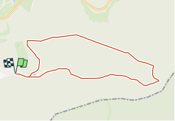

5,4 km | 7,4 km-effort

Tous les sentiers balisés d’Europe GUIDE+


Application GPS de randonnée GRATUITE
 SityTrail
IGN / Instituts géographiques
SityTrail World
Le monde est à vous
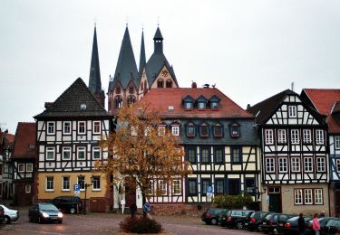
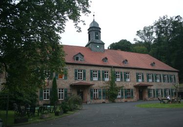
Randonnée A pied de 9,2 km à découvrir à Hesse, Main-Kinzig-Kreis, Gründau. Cette randonnée est proposée par SityTrail - itinéraires balisés pédestres.
Randonnée créée par Gemeinde Gründau.
complete
Symbole: Weißes Geweih auf grünem Hintergrund
Site web: http://www.gruendau.de/gruendaushop-rad-und-wanderkarte.html
 "
data-pinterest-text="Pin it"
data-tweet-text="share on twitter"
data-facebook-share-url="https://www.sitytrail.com/fr/trails/3094168-grundau--wanderwege-xrund-um-die-gettenbacher-weiherx-nrx5/?photo=1#lg=1&slide=1"
data-twitter-share-url="https://www.sitytrail.com/fr/trails/3094168-grundau--wanderwege-xrund-um-die-gettenbacher-weiherx-nrx5/?photo=1#lg=1&slide=1"
data-googleplus-share-url="https://www.sitytrail.com/fr/trails/3094168-grundau--wanderwege-xrund-um-die-gettenbacher-weiherx-nrx5/?photo=1#lg=1&slide=1"
data-pinterest-share-url="https://www.sitytrail.com/fr/trails/3094168-grundau--wanderwege-xrund-um-die-gettenbacher-weiherx-nrx5/?photo=1#lg=1&slide=1">
"
data-pinterest-text="Pin it"
data-tweet-text="share on twitter"
data-facebook-share-url="https://www.sitytrail.com/fr/trails/3094168-grundau--wanderwege-xrund-um-die-gettenbacher-weiherx-nrx5/?photo=1#lg=1&slide=1"
data-twitter-share-url="https://www.sitytrail.com/fr/trails/3094168-grundau--wanderwege-xrund-um-die-gettenbacher-weiherx-nrx5/?photo=1#lg=1&slide=1"
data-googleplus-share-url="https://www.sitytrail.com/fr/trails/3094168-grundau--wanderwege-xrund-um-die-gettenbacher-weiherx-nrx5/?photo=1#lg=1&slide=1"
data-pinterest-share-url="https://www.sitytrail.com/fr/trails/3094168-grundau--wanderwege-xrund-um-die-gettenbacher-weiherx-nrx5/?photo=1#lg=1&slide=1">
 "
data-pinterest-text="Pin it"
data-tweet-text="share on twitter"
data-facebook-share-url="https://www.sitytrail.com/fr/trails/3094168-grundau--wanderwege-xrund-um-die-gettenbacher-weiherx-nrx5/?photo=2#lg=1&slide=2"
data-twitter-share-url="https://www.sitytrail.com/fr/trails/3094168-grundau--wanderwege-xrund-um-die-gettenbacher-weiherx-nrx5/?photo=2#lg=1&slide=2"
data-googleplus-share-url="https://www.sitytrail.com/fr/trails/3094168-grundau--wanderwege-xrund-um-die-gettenbacher-weiherx-nrx5/?photo=2#lg=1&slide=2"
data-pinterest-share-url="https://www.sitytrail.com/fr/trails/3094168-grundau--wanderwege-xrund-um-die-gettenbacher-weiherx-nrx5/?photo=2#lg=1&slide=2">
"
data-pinterest-text="Pin it"
data-tweet-text="share on twitter"
data-facebook-share-url="https://www.sitytrail.com/fr/trails/3094168-grundau--wanderwege-xrund-um-die-gettenbacher-weiherx-nrx5/?photo=2#lg=1&slide=2"
data-twitter-share-url="https://www.sitytrail.com/fr/trails/3094168-grundau--wanderwege-xrund-um-die-gettenbacher-weiherx-nrx5/?photo=2#lg=1&slide=2"
data-googleplus-share-url="https://www.sitytrail.com/fr/trails/3094168-grundau--wanderwege-xrund-um-die-gettenbacher-weiherx-nrx5/?photo=2#lg=1&slide=2"
data-pinterest-share-url="https://www.sitytrail.com/fr/trails/3094168-grundau--wanderwege-xrund-um-die-gettenbacher-weiherx-nrx5/?photo=2#lg=1&slide=2">
 "
data-pinterest-text="Pin it"
data-tweet-text="share on twitter"
data-facebook-share-url="https://www.sitytrail.com/fr/trails/3094168-grundau--wanderwege-xrund-um-die-gettenbacher-weiherx-nrx5/?photo=3#lg=1&slide=3"
data-twitter-share-url="https://www.sitytrail.com/fr/trails/3094168-grundau--wanderwege-xrund-um-die-gettenbacher-weiherx-nrx5/?photo=3#lg=1&slide=3"
data-googleplus-share-url="https://www.sitytrail.com/fr/trails/3094168-grundau--wanderwege-xrund-um-die-gettenbacher-weiherx-nrx5/?photo=3#lg=1&slide=3"
data-pinterest-share-url="https://www.sitytrail.com/fr/trails/3094168-grundau--wanderwege-xrund-um-die-gettenbacher-weiherx-nrx5/?photo=3#lg=1&slide=3">
"
data-pinterest-text="Pin it"
data-tweet-text="share on twitter"
data-facebook-share-url="https://www.sitytrail.com/fr/trails/3094168-grundau--wanderwege-xrund-um-die-gettenbacher-weiherx-nrx5/?photo=3#lg=1&slide=3"
data-twitter-share-url="https://www.sitytrail.com/fr/trails/3094168-grundau--wanderwege-xrund-um-die-gettenbacher-weiherx-nrx5/?photo=3#lg=1&slide=3"
data-googleplus-share-url="https://www.sitytrail.com/fr/trails/3094168-grundau--wanderwege-xrund-um-die-gettenbacher-weiherx-nrx5/?photo=3#lg=1&slide=3"
data-pinterest-share-url="https://www.sitytrail.com/fr/trails/3094168-grundau--wanderwege-xrund-um-die-gettenbacher-weiherx-nrx5/?photo=3#lg=1&slide=3">

A pied
A pied
A pied
A pied
A pied
A pied

A pied
A pied
A pied