Randonnée A pied Schalksmühle - [A4] Winkeln - Heedfeld - Photo

Tous les sentiers balisés d’Europe PRO

© OpenStreetMap contributors
Longueur
Longueur
6,8 km
Altitude max
Altitude max
438 m
Dénivelé positif
Dénivelé positif
185 m
Km-Effort
Km-Effort  
9,3 km
Altitude min
Altitude min
321 m
Dénivelé négatif
Dénivelé négatif
185 m
Boucle
Boucle
Oui
Balise
Balise
Date de création :
2022-02-11 15:14:49.182
Dernière modification :
2022-02-11 15:14:49.182

(0 Avis)

A pied
A pied
2h06
Difficulté : Facile

Scannez ce code QR pour ouvrir la randonnée dans l'application SityTrail

Application GPS de randonnée GRATUITE

Logo SityTrail SityTrail

IGN / Instituts géographiques

Télécharger SityTrail sur l'App Store Télécharger SityTrail sur Google Play

Logo SityTrail SityTrail World

Le monde est à vous

Télécharger SityTrail sur l'App Store Télécharger SityTrail sur Google Play Télécharger SityTrail sur Huawei AppGallery

À propos

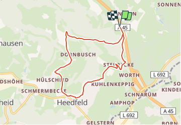
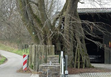
Randonnée A pied de 6,8 km à découvrir à Rhénanie-du-Nord-Westphalie, Märkischer Kreis, Schalksmühle. Cette randonnée est proposée par SityTrail - itinéraires balisés pédestres.

Description

Randonnée créée par Sauerländischer Gebirgsverein.

Photos

Localisation

Pays :
Allemagne
Région :
Rhénanie-du-Nord-Westphalie
Département/Province :
Märkischer Kreis
Commune :
Schalksmühle
Localité :
Unknown
Départ:(UTM)
402272 ; 5681063 (32U) N.

Randonnées à proximité

Randonnée A pied Nachrodt-Wiblingwerde - Wiblingwerde - Veserde - Photo
A pied
PRO

A pied

Facile
Nachrodt-Wiblingwerde, Rhénanie-du-Nord-Westphalie, Märkischer Kreis, Allemagne
8,9 km | 11,8 km-effort
2h 40min
Oui
Randonnée A pied Altena - [A2] Um den Tiergarten - Photo
A pied
PRO

A pied

Facile
Altena, Rhénanie-du-Nord-Westphalie, Märkischer Kreis, Allemagne
8,7 km | 12,8 km-effort
2h 54min
Oui
Randonnée A pied Inconnu - Rundweg A7 Höhenweg Links der Volme (Dahl) - Photo
A pied
PRO

A pied

Facile
Inconnu, Rhénanie-du-Nord-Westphalie, Hagen, Allemagne
4,5 km | 7,5 km-effort
1h 42min
Non
Randonnée A pied Inconnu - Rundweg A4 Asmeckeweg (Dahl) - Photo
A pied
PRO

A pied

Facile
Inconnu, Rhénanie-du-Nord-Westphalie, Hagen, Allemagne
5,5 km | 7,8 km-effort
1h 46min
Oui
Randonnée A pied Inconnu - Rundweg A8 Höhenweg rechts der Volme (Dahl) - Photo
A pied
PRO

A pied

Facile
Inconnu, Rhénanie-du-Nord-Westphalie, Hagen, Allemagne
8,9 km | 12,5 km-effort
2h 49min
Oui
Randonnée A pied Inconnu - Rundweg A3 Denkmalweg (Dahl) - Photo
A pied
PRO

A pied

Facile
Inconnu, Rhénanie-du-Nord-Westphalie, Hagen, Allemagne
5,4 km | 8 km-effort
1h 48min
Oui
Randonnée A pied Inconnu - Rundweg A2 Aussichtsplateauweg (Dahl) - Photo
A pied
PRO

A pied

Facile
Inconnu, Rhénanie-du-Nord-Westphalie, Hagen, Allemagne
5,8 km | 7,9 km-effort
1h 47min
Oui
Randonnée A pied Inconnu - Rundweg A1 Rumscheider Femelinde (Dahl) - Photo
A pied
PRO

A pied

Facile
Inconnu, Rhénanie-du-Nord-Westphalie, Hagen, Allemagne
6,8 km | 10,3 km-effort
2h 20min
Oui
Randonnée A pied Inconnu - Gipfelkreuzweg - Photo
A pied
PRO

A pied

Facile
Inconnu, Rhénanie-du-Nord-Westphalie, Hagen, Allemagne
12,2 km | 18,8 km-effort
4h 16min
Non


Fermer
Mes abonnements