![](/images/other/stat-length.png)
![Randonnée A pied Grassau - Genial Vital 8 - Photo](https://media.geolcdn.com/t/1900/400/24839db7-2384-4dbf-92cf-4f1ba47dd73c.jpeg&format=pjpeg&maxdim=2)
Genial Vital 8
SityTrail - itinéraires balisés pédestres
Tous les sentiers balisés d’Europe GUIDE+
![Longueur](/images/other/stat-length.png)
Longueur
9,5 km
![Altitude max](https://static1.geolcdn.com/siteimages/upload/files/1508320355ic_sort_altitude_max_24dp.png)
Altitude max
1456 m
![Dénivelé positif](https://static1.geolcdn.com/siteimages/upload/files/1508320355ic_sort_den_pos_24dp.png)
Dénivelé positif
925 m
![Km-Effort](/images/other/stat-length.png)
Km-Effort
18,8 km
![Altitude min](https://static1.geolcdn.com/siteimages/upload/files/1508320355ic_sort_altitude_min_24dp.png)
Altitude min
548 m
![Dénivelé négatif](https://static1.geolcdn.com/siteimages/upload/files/1508320355ic_sort_den_neg_24dp.png)
Dénivelé négatif
21 m
![Boucle](https://static1.geolcdn.com/siteimages/upload/files/16400158638029165_repeat_loop_refresh_sync_direction_icon.png)
Boucle
Non
Balise
Date de création :
2022-02-11 15:08:06.705
Dernière modification :
2022-02-11 15:08:06.705
![A pied](https://static1.geolcdn.com/sitytour/trail-icons/100.png)
4h16
Difficulté : Facile
![Scannez ce code QR pour ouvrir la randonnée dans l'application SityTrail](https://capi.geolives.com/qq0zvz2zws4bq2lad0pu/sitytour/trails/3093898/qr.png?size=200)
Application GPS de randonnée GRATUITE
À propos
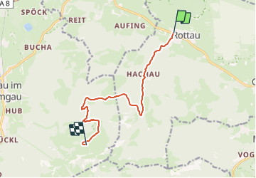
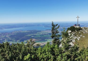
Randonnée A pied de 9,5 km à découvrir à Bavière, Landkreis Traunstein, Grassau. Cette randonnée est proposée par SityTrail - itinéraires balisés pédestres.
Description
Randonnée créée par Grassau & Rottau.
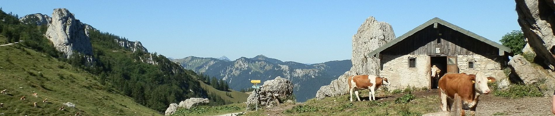
Symbole: Weißes Schild mit gelber Schrift "Genial Vital" mit blauem oberen Rand und Bergkulisse am unteren Rand
Localisation
Pays :
Allemagne
Région :
Bavière
Département/Province :
Landkreis Traunstein
Commune :
Grassau
Localité :
Unknown
Départ:(Dec)
Départ:(UTM)
305859 ; 5296786 (33T) N.
Commentaires
Randonnées à proximité
![Randonnée A pied Prien am Chiemsee - Priener Postkartenweg - Photo](https://media.geolcdn.com/t/375/260/e02e5267-41a2-46b2-a4c0-10b7a412546e.jpeg&format=jpg&maxdim=2)
![A pied A pied](https://static1.geolcdn.com/sitytour/trail-icons/100.png)
Priener Postkartenweg
A pied
Facile
Prien am Chiemsee,
Bavière,
Landkreis Rosenheim,
Allemagne
![](/images/other/stat-length.png)
4,8 km | 6 km-effort
1h 22min
![](https://static1.geolcdn.com/siteimages/upload/files/16400158638029165_repeat_loop_refresh_sync_direction_icon.png)
Non
![Randonnée A pied Marquartstein - SalzAlpenTour - Marquartstein - Photo](https://media.geolcdn.com/t/375/260/6a08c7a4-18e6-432b-8d18-6c58893e510c.jpeg&format=jpg&maxdim=2)
![A pied A pied](https://static1.geolcdn.com/sitytour/trail-icons/100.png)
SalzAlpenTour - Marquartstein
A pied
Facile
Marquartstein,
Bavière,
Landkreis Traunstein,
Allemagne
![](/images/other/stat-length.png)
3,2 km | 4,9 km-effort
1h 6min
![](https://static1.geolcdn.com/siteimages/upload/files/16400158638029165_repeat_loop_refresh_sync_direction_icon.png)
Non
![Randonnée A pied Grassau - Wanderweg 4 - Grassau - Photo](https://media.geolcdn.com/t/375/260/d24c11c6-c82e-4efd-b811-b1ed9001aaff.jpeg&format=jpg&maxdim=2)
![A pied A pied](https://static1.geolcdn.com/sitytour/trail-icons/100.png)
Wanderweg 4 - Grassau
A pied
Facile
Grassau,
Bavière,
Landkreis Traunstein,
Allemagne
![](/images/other/stat-length.png)
6,3 km | 13 km-effort
2h 57min
![](https://static1.geolcdn.com/siteimages/upload/files/16400158638029165_repeat_loop_refresh_sync_direction_icon.png)
Non
![Randonnée A pied Grassau - SalzAlpenTour - Über die Grassauer Almen - Photo](https://media.geolcdn.com/t/375/260/5cc8f884-fa03-4b69-aeeb-fdd283aca3e7.jpeg&format=jpg&maxdim=2)
![A pied A pied](https://static1.geolcdn.com/sitytour/trail-icons/100.png)
SalzAlpenTour - Über die Grassauer Almen
A pied
Facile
Grassau,
Bavière,
Landkreis Traunstein,
Allemagne
![](/images/other/stat-length.png)
10,6 km | 18,7 km-effort
4h 14min
![](https://static1.geolcdn.com/siteimages/upload/files/16400158638029165_repeat_loop_refresh_sync_direction_icon.png)
Non
![Randonnée A pied Marquartstein - Wanderweg 12 - Staudach - Photo](https://media.geolcdn.com/t/375/260/457a24b3-c1bf-43db-afd7-f27dcbdf84a9.jpeg&format=jpg&maxdim=2)
![A pied A pied](https://static1.geolcdn.com/sitytour/trail-icons/100.png)
Wanderweg 12 - Staudach
A pied
Facile
Marquartstein,
Bavière,
Landkreis Traunstein,
Allemagne
![](/images/other/stat-length.png)
3,2 km | 3,4 km-effort
46min
![](https://static1.geolcdn.com/siteimages/upload/files/16400158638029165_repeat_loop_refresh_sync_direction_icon.png)
Non
![Randonnée A pied Bernau am Chiemsee - eon - Trail - Photo](https://media.geolcdn.com/t/375/260/af754070-0237-4ac7-a6f5-78d0148ad2bc.jpeg&format=jpg&maxdim=2)
![A pied A pied](https://static1.geolcdn.com/sitytour/trail-icons/100.png)
eon - Trail
A pied
Facile
Bernau am Chiemsee,
Bavière,
Landkreis Rosenheim,
Allemagne
![](/images/other/stat-length.png)
3,5 km | 3,9 km-effort
53min
![](https://static1.geolcdn.com/siteimages/upload/files/16400158638029165_repeat_loop_refresh_sync_direction_icon.png)
Non
![Randonnée A pied Grassau - Wanderweg 21 - Rottau/Übersee - Photo](https://media.geolcdn.com/t/375/260/728197dc-3f85-4c0b-9c64-e77d3b389e64.jpeg&format=jpg&maxdim=2)
![A pied A pied](https://static1.geolcdn.com/sitytour/trail-icons/100.png)
Wanderweg 21 - Rottau/Übersee
A pied
Facile
Grassau,
Bavière,
Landkreis Traunstein,
Allemagne
![](/images/other/stat-length.png)
6,3 km | 7,5 km-effort
1h 42min
![](https://static1.geolcdn.com/siteimages/upload/files/16400158638029165_repeat_loop_refresh_sync_direction_icon.png)
Non
![Randonnée A pied Grassau - Wanderweg 2 - Grassau - Photo](https://media.geolcdn.com/t/375/260/939b449c-8bfe-4713-8ba8-45392e182414.jpeg&format=jpg&maxdim=2)
![A pied A pied](https://static1.geolcdn.com/sitytour/trail-icons/100.png)
Wanderweg 2 - Grassau
A pied
Facile
Grassau,
Bavière,
Landkreis Traunstein,
Allemagne
![](/images/other/stat-length.png)
3,1 km | 3,4 km-effort
46min
![](https://static1.geolcdn.com/siteimages/upload/files/16400158638029165_repeat_loop_refresh_sync_direction_icon.png)
Non
![Randonnée A pied Grassau - Zum Moorrundweg - Photo](https://media.geolcdn.com/t/375/260/60b88188-01f0-4419-a5de-16e9925a7169.jpeg&format=jpg&maxdim=2)
![A pied A pied](https://static1.geolcdn.com/sitytour/trail-icons/100.png)
Zum Moorrundweg
A pied
Facile
Grassau,
Bavière,
Landkreis Traunstein,
Allemagne
![](/images/other/stat-length.png)
4,2 km | 4,5 km-effort
1h 1min
![](https://static1.geolcdn.com/siteimages/upload/files/16400158638029165_repeat_loop_refresh_sync_direction_icon.png)
Non