Randonnée A pied Regenstauf - Wilder Mann 005, Naturpark Vorderer Bayerischer Wald - Photo

Wilder Mann 005, Naturpark Vorderer Bayerischer Wald

Tous les sentiers balisés d’Europe PRO

© OpenStreetMap contributors
Longueur
Longueur
11,2 km
Altitude max
Altitude max
537 m
Dénivelé positif
Dénivelé positif
311 m
Km-Effort
Km-Effort  
15,2 km
Altitude min
Altitude min
344 m
Dénivelé négatif
Dénivelé négatif
294 m
Boucle
Boucle
Non
Balise
Balise
Date de création :
2022-02-11 15:08:00.795
Dernière modification :
2022-02-11 15:08:00.795

(0 Avis)

A pied
A pied
3h27
Difficulté : Facile

Scannez ce code QR pour ouvrir la randonnée dans l'application SityTrail

Application GPS de randonnée GRATUITE

Logo SityTrail SityTrail

IGN / Instituts géographiques

Télécharger SityTrail sur l'App Store Télécharger SityTrail sur Google Play

Logo SityTrail SityTrail World

Le monde est à vous

Télécharger SityTrail sur l'App Store Télécharger SityTrail sur Google Play Télécharger SityTrail sur Huawei AppGallery

À propos

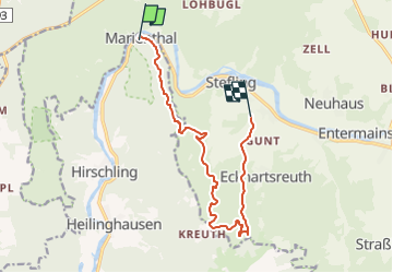
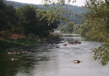
Randonnée A pied de 11,2 km à découvrir à Bavière, Landkreis Regensburg, Regenstauf. Cette randonnée est proposée par SityTrail - itinéraires balisés pédestres.

Description

Randonnée créée par Verein Naturpark Vorderer Bayerischer Wald.

FIXME: Nicht alle Wegsegmente erfaßt.

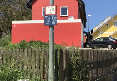
Symbole: Auf einem rechteckigen weißen Grund in Schwarz links der Wilde Mann (Zeichnung), rechts die Wanderwegnummer, darüber der Text "WANDERWEG".

Photos

Localisation

Pays :
Allemagne
Région :
Bavière
Département/Province :
Landkreis Regensburg
Commune :
Regenstauf
Localité :
Unknown
Départ:(UTM)
294337 ; 5455969 (33U) N.

Randonnées à proximité

Randonnée A pied Regenstauf - Tour 9 »Flusswanderung« - Photo
A pied
PRO

A pied

Facile
Regenstauf, Bavière, Landkreis Regensburg, Allemagne
8,1 km | 9,8 km-effort
2h 13min
Oui
Randonnée A pied Nittenau - Wilder Mann 009 »Regentalwanderweg«, Naturpark Vorderer Bayerischer Wald - Photo
A pied
PRO

A pied

Facile
Nittenau, Bavière, Landkreis Schwandorf, Allemagne
8 km | 9,1 km-effort
2h 4min
Non
Randonnée A pied Regenstauf - Tour 6 »Schwarzbergtour« - Photo
A pied
PRO

A pied

Facile
Regenstauf, Bavière, Landkreis Regensburg, Allemagne
10,1 km | 13,7 km-effort
3h 6min
Oui
Randonnée A pied Maxhütte-Haidhof - Regentalsteig nach Hirschling (Gelbe 8) - Photo
A pied
PRO

A pied

Facile
Maxhütte-Haidhof, Bavière, Landkreis Schwandorf, Allemagne
8,3 km | 11,6 km-effort
2h 38min
Non
Randonnée A pied Nittenau - Wanderwege rund um Nittenau - 01 - Wasserstein - Photo
A pied
PRO

A pied

Facile
Nittenau, Bavière, Landkreis Schwandorf, Allemagne
7,5 km | 9,8 km-effort
2h 13min
Non
Randonnée A pied Regenstauf - Wanderwege rund um Nittenau - 02 - Wackelstein - Photo
A pied
PRO

A pied

Facile
Regenstauf, Bavière, Landkreis Regensburg, Allemagne
9,3 km | 13,1 km-effort
2h 58min
Non
Randonnée A pied Nittenau - Drei-Burgen-Weg (Nittenau) - Photo
A pied
PRO

A pied

Facile
Nittenau, Bavière, Landkreis Schwandorf, Allemagne
6,2 km | 8,5 km-effort
1h 55min
Non
Randonnée A pied Nittenau - Wilder Mann 011, Naturpark Vorderer Bayerischer Wald - Photo
A pied
PRO

A pied

Facile
Nittenau, Bavière, Landkreis Schwandorf, Allemagne
7,5 km | 10,4 km-effort
2h 22min
Non
Randonnée A pied Nittenau - O 58 Stefling - Marienthal (Rotes Rechteck) - Photo
A pied
PRO

A pied

Facile
Nittenau, Bavière, Landkreis Schwandorf, Allemagne
5,2 km | 7,5 km-effort
1h 41min
Non


Fermer
Mes abonnements