![](/images/other/stat-length.png)
![Randonnée A pied Unknown - Rheinburgenweg Zugangsweg Koblenz - Photo](https://media.geolcdn.com/t/1900/400/de85e909-de55-41ff-b279-432aa6c66811.jpeg&format=pjpeg&maxdim=2)
Rheinburgenweg Zugangsweg Koblenz
SityTrail - itinéraires balisés pédestres
Tous les sentiers balisés d’Europe GUIDE+
![Longueur](/images/other/stat-length.png)
Longueur
5,1 km
![Altitude max](https://static1.geolcdn.com/siteimages/upload/files/1508320355ic_sort_altitude_max_24dp.png)
Altitude max
179 m
![Dénivelé positif](https://static1.geolcdn.com/siteimages/upload/files/1508320355ic_sort_den_pos_24dp.png)
Dénivelé positif
25 m
![Km-Effort](/images/other/stat-length.png)
Km-Effort
5,8 km
![Altitude min](https://static1.geolcdn.com/siteimages/upload/files/1508320355ic_sort_altitude_min_24dp.png)
Altitude min
62 m
![Dénivelé négatif](https://static1.geolcdn.com/siteimages/upload/files/1508320355ic_sort_den_neg_24dp.png)
Dénivelé négatif
134 m
![Boucle](https://static1.geolcdn.com/siteimages/upload/files/16400158638029165_repeat_loop_refresh_sync_direction_icon.png)
Boucle
Non
Balise
Date de création :
2022-02-11 14:45:11.287
Dernière modification :
2022-02-11 14:45:11.287
![A pied](https://static1.geolcdn.com/sitytour/trail-icons/100.png)
1h19
Difficulté : Facile
![Scannez ce code QR pour ouvrir la randonnée dans l'application SityTrail](https://capi.geolives.com/qq0zvz2zws4bq2lad0pu/sitytour/trails/3093227/qr.png?size=200)
Application GPS de randonnée GRATUITE
À propos
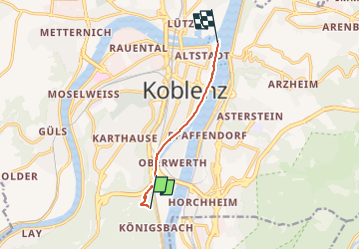
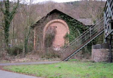
Randonnée A pied de 5,1 km à découvrir à Rhénanie-Palatinat, Coblence. Cette randonnée est proposée par SityTrail - itinéraires balisés pédestres.
Description
Präsentiert die touristischen Angebote zwischen Rüdesheim und Bingen im Süden und dem Beginn des Siebengebirges im Norden.
Site web: https://www.rheinburgenweg.com/
Localisation
Pays :
Allemagne
Région :
Rhénanie-Palatinat
Département/Province :
Coblence
Commune :
Unknown
Localité :
Unknown
Départ:(Dec)
Départ:(UTM)
399108 ; 5575999 (32U) N.
Commentaires
Randonnées à proximité
![Randonnée A pied Lahnstein - Rundwanderweg A - Photo](https://media.geolcdn.com/t/375/260/b3ba714d-2c3e-4a80-887e-6fcddb8584ce.jpeg&format=jpg&maxdim=2)
![A pied A pied](https://static1.geolcdn.com/sitytour/trail-icons/100.png)
Rundwanderweg A
A pied
Facile
Lahnstein,
Rhénanie-Palatinat,
Rhein-Lahn-Kreis,
Allemagne
![](/images/other/stat-length.png)
4,2 km | 6 km-effort
1h 21min
![](https://static1.geolcdn.com/siteimages/upload/files/16400158638029165_repeat_loop_refresh_sync_direction_icon.png)
Oui
![Randonnée A pied Lahnstein - Rundwanderweg B - Photo](https://media.geolcdn.com/t/375/260/35ccf662-4335-4af1-a7ec-7cb0f2ffa796.jpeg&format=jpg&maxdim=2)
![A pied A pied](https://static1.geolcdn.com/sitytour/trail-icons/100.png)
Rundwanderweg B
A pied
Facile
Lahnstein,
Rhénanie-Palatinat,
Rhein-Lahn-Kreis,
Allemagne
![](/images/other/stat-length.png)
7,1 km | 10,1 km-effort
2h 18min
![](https://static1.geolcdn.com/siteimages/upload/files/16400158638029165_repeat_loop_refresh_sync_direction_icon.png)
Oui
![Randonnée A pied Lahnstein - Rheinsteig-Exkursion Spießborner Grillhütte - Photo](https://media.geolcdn.com/t/375/260/b2377cd6-e4ec-4606-b2af-383b46dde74f.jpeg&format=jpg&maxdim=2)
![A pied A pied](https://static1.geolcdn.com/sitytour/trail-icons/100.png)
Rheinsteig-Exkursion Spießborner Grillhütte
A pied
Facile
Lahnstein,
Rhénanie-Palatinat,
Rhein-Lahn-Kreis,
Allemagne
![](/images/other/stat-length.png)
3,8 km | 4,8 km-effort
1h 5min
![](https://static1.geolcdn.com/siteimages/upload/files/16400158638029165_repeat_loop_refresh_sync_direction_icon.png)
Non
![Randonnée A pied - Rheinsteig-Zuweg Arzheim - Photo](https://media.geolcdn.com/t/375/260/b17c45c2-7597-4f83-87a3-5915ac74ea25.jpeg&format=jpg&maxdim=2)
![A pied A pied](https://static1.geolcdn.com/sitytour/trail-icons/100.png)
Rheinsteig-Zuweg Arzheim
A pied
Facile
,
Rhénanie-Palatinat,
Coblence,
Allemagne
![](/images/other/stat-length.png)
3,5 km | 5,1 km-effort
1h 9min
![](https://static1.geolcdn.com/siteimages/upload/files/16400158638029165_repeat_loop_refresh_sync_direction_icon.png)
Non
![Randonnée A pied - Rheinsteig-Zuweg Asterstein - Photo](https://media.geolcdn.com/t/375/260/b17c45c2-7597-4f83-87a3-5915ac74ea25.jpeg&format=jpg&maxdim=2)
![A pied A pied](https://static1.geolcdn.com/sitytour/trail-icons/100.png)
Rheinsteig-Zuweg Asterstein
A pied
Facile
,
Rhénanie-Palatinat,
Coblence,
Allemagne
![](/images/other/stat-length.png)
3,3 km | 4,7 km-effort
1h 3min
![](https://static1.geolcdn.com/siteimages/upload/files/16400158638029165_repeat_loop_refresh_sync_direction_icon.png)
Non
![Randonnée A pied Lahnstein - Rundwanderweg A2 - Photo](https://media.geolcdn.com/t/375/260/619ec1e9-d3a9-42cb-9013-c11b363c7d0e.jpeg&format=jpg&maxdim=2)
![A pied A pied](https://static1.geolcdn.com/sitytour/trail-icons/100.png)
Rundwanderweg A2
A pied
Facile
Lahnstein,
Rhénanie-Palatinat,
Rhein-Lahn-Kreis,
Allemagne
![](/images/other/stat-length.png)
3 km | 4,8 km-effort
1h 5min
![](https://static1.geolcdn.com/siteimages/upload/files/16400158638029165_repeat_loop_refresh_sync_direction_icon.png)
Non
![Randonnée A pied Lahnstein - Rundwanderweg B2 - Photo](https://media.geolcdn.com/t/375/260/35ccf662-4335-4af1-a7ec-7cb0f2ffa796.jpeg&format=jpg&maxdim=2)
![A pied A pied](https://static1.geolcdn.com/sitytour/trail-icons/100.png)
Rundwanderweg B2
A pied
Facile
Lahnstein,
Rhénanie-Palatinat,
Rhein-Lahn-Kreis,
Allemagne
![](/images/other/stat-length.png)
4,7 km | 6 km-effort
1h 22min
![](https://static1.geolcdn.com/siteimages/upload/files/16400158638029165_repeat_loop_refresh_sync_direction_icon.png)
Non
![Randonnée A pied Lahnstein - Rundwanderweg B1 - Photo](https://media.geolcdn.com/t/375/260/80aeb201-bc00-46e6-b6ee-506c4a07069c.jpeg&format=jpg&maxdim=2)
![A pied A pied](https://static1.geolcdn.com/sitytour/trail-icons/100.png)
Rundwanderweg B1
A pied
Facile
Lahnstein,
Rhénanie-Palatinat,
Rhein-Lahn-Kreis,
Allemagne
![](/images/other/stat-length.png)
3 km | 4,5 km-effort
1h 1min
![](https://static1.geolcdn.com/siteimages/upload/files/16400158638029165_repeat_loop_refresh_sync_direction_icon.png)
Non
![Randonnée A pied Lahnstein - Rundwanderweg D1 - Photo](https://media.geolcdn.com/t/375/260/b2377cd6-e4ec-4606-b2af-383b46dde74f.jpeg&format=jpg&maxdim=2)
![A pied A pied](https://static1.geolcdn.com/sitytour/trail-icons/100.png)
Rundwanderweg D1
A pied
Facile
Lahnstein,
Rhénanie-Palatinat,
Rhein-Lahn-Kreis,
Allemagne
![](/images/other/stat-length.png)
3,7 km | 4,4 km-effort
1h 0min
![](https://static1.geolcdn.com/siteimages/upload/files/16400158638029165_repeat_loop_refresh_sync_direction_icon.png)
Oui