Randonnée A pied Gackenbach - Wäller Tour Buchfinkenland - Photo

Tous les sentiers balisés d’Europe PRO

© OpenStreetMap contributors
Longueur
Longueur
14,3 km
Altitude max
Altitude max
430 m
Dénivelé positif
Dénivelé positif
388 m
Km-Effort
Km-Effort  
19,5 km
Altitude min
Altitude min
174 m
Dénivelé négatif
Dénivelé négatif
379 m
Boucle
Boucle
Oui
Balise
Balise
Date de création :
2022-02-11 14:37:16.126
Dernière modification :
2022-02-11 14:37:16.126

(0 Avis)

A pied
A pied
4h25
Difficulté : Facile

Scannez ce code QR pour ouvrir la randonnée dans l'application SityTrail

Application GPS de randonnée GRATUITE

Logo SityTrail SityTrail

IGN / Instituts géographiques

Télécharger SityTrail sur l'App Store Télécharger SityTrail sur Google Play

Logo SityTrail SityTrail World

Le monde est à vous

Télécharger SityTrail sur l'App Store Télécharger SityTrail sur Google Play Télécharger SityTrail sur Huawei AppGallery

À propos

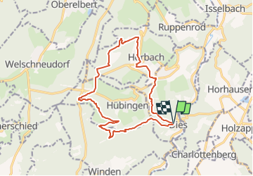
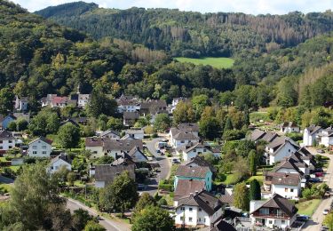
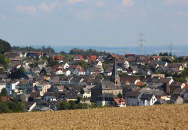
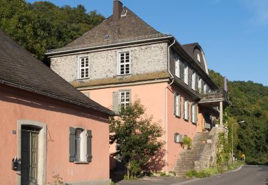
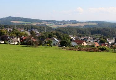
Randonnée A pied de 14,3 km à découvrir à Rhénanie-Palatinat, Westerwaldkreis, Gackenbach. Cette randonnée est proposée par SityTrail - itinéraires balisés pédestres.

Description

Symbole: grünes geschwungenes W auf weißem Grund

Photos

Localisation

Pays :
Allemagne
Région :
Rhénanie-Palatinat
Département/Province :
Westerwaldkreis
Commune :
Gackenbach
Localité :
Unknown
Départ:(UTM)
419245 ; 5578512 (32U) N.

Randonnées à proximité

Randonnée A pied Welschneudorf - Wäller Tour Elberthöhen - Photo
A pied
PRO

A pied

Moyen
Welschneudorf, Rhénanie-Palatinat, Westerwaldkreis, Allemagne
15,6 km | 20 km-effort
4h 37min
Oui
Randonnée A pied Obernhof - Vier-Täler-Tour - Photo
A pied
PRO

A pied

Moyen
Obernhof, Rhénanie-Palatinat, Rhein-Lahn-Kreis, Allemagne
18,2 km | 24 km-effort
5h 26min
Non
Randonnée A pied Obernhof - Gelbachhöhen-Tour - Photo
A pied
PRO

A pied

Facile
Obernhof, Rhénanie-Palatinat, Rhein-Lahn-Kreis, Allemagne
11,8 km | 17,1 km-effort
3h 52min
Oui
Randonnée A pied Laurenburg - Burgweg - Photo
A pied
PRO

A pied

Facile
Laurenburg, Rhénanie-Palatinat, Rhein-Lahn-Kreis, Allemagne
4 km | 5,6 km-effort
1h 16min
Non
Randonnée A pied Geilnau - DE-G3 - Photo
A pied
PRO

A pied

Facile
Geilnau, Rhénanie-Palatinat, Rhein-Lahn-Kreis, Allemagne
7,1 km | 9,8 km-effort
2h 14min
Oui
Randonnée A pied Geilnau - DE-G2 - Photo
A pied
PRO

A pied

Facile
Geilnau, Rhénanie-Palatinat, Rhein-Lahn-Kreis, Allemagne
4,9 km | 7 km-effort
1h 34min
Oui
Randonnée A pied Geilnau - DE-G1 - Photo
A pied
PRO

A pied

Facile
Geilnau, Rhénanie-Palatinat, Rhein-Lahn-Kreis, Allemagne
5 km | 7,6 km-effort
1h 43min
Oui
Randonnée A pied Seelbach - Klosterweg - Photo
A pied
PRO

A pied

Facile
Seelbach, Rhénanie-Palatinat, Rhein-Lahn-Kreis, Allemagne
14,9 km | 19,5 km-effort
4h 26min
Oui
Randonnée A pied Hübingen - Buchfinkenland kleiner Rundwanderweg B3 - Photo
A pied
PRO

A pied

Facile
Hübingen, Rhénanie-Palatinat, Westerwaldkreis, Allemagne
7,5 km | 10,2 km-effort
2h 19min
Oui


Fermer
Mes abonnements