Randonnée A pied Gerswalde - Stiernseerundweg - Photo

Tous les sentiers balisés d’Europe PRO

© OpenStreetMap contributors
Longueur
Longueur
8,2 km
Altitude max
Altitude max
79 m
Dénivelé positif
Dénivelé positif
88 m
Km-Effort
Km-Effort  
9,3 km
Altitude min
Altitude min
43 m
Dénivelé négatif
Dénivelé négatif
63 m
Boucle
Boucle
Non
Balise
Balise
Date de création :
2022-02-11 14:35:34.381
Dernière modification :
2022-02-11 14:35:34.381

(0 Avis)

A pied
A pied
2h07
Difficulté : Facile

Scannez ce code QR pour ouvrir la randonnée dans l'application SityTrail

Application GPS de randonnée GRATUITE

Logo SityTrail SityTrail

IGN / Instituts géographiques

Télécharger SityTrail sur l'App Store Télécharger SityTrail sur Google Play

Logo SityTrail SityTrail World

Le monde est à vous

Télécharger SityTrail sur l'App Store Télécharger SityTrail sur Google Play Télécharger SityTrail sur Huawei AppGallery

À propos

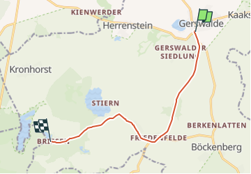
Randonnée A pied de 8,2 km à découvrir à Brandebourg, Uckermark, Gerswalde. Cette randonnée est proposée par SityTrail - itinéraires balisés pédestres.

Description

Randonnée créée par tmu Tourismus Marketing Uckermark GmbH.

Symbole: Yellow dot on white ground

Photos

Localisation

Pays :
Allemagne
Région :
Brandebourg
Département/Province :
Uckermark
Commune :
Gerswalde
Localité :
Gerswalde
Départ:(UTM)
416297 ; 5891785 (33U) N.

Randonnées à proximité

Randonnée A pied Flieth-Stegelitz - Rundweg Gerswalde - Photo
A pied
PRO

A pied

Moyen
Flieth-Stegelitz, Brandebourg, Uckermark, Allemagne
21 km | 24 km-effort
5h 20min
Oui
Randonnée A pied Gerswalde - Wanderweg Gerswalde - Gramzow - Photo
A pied
PRO

A pied

Facile
Gerswalde, Brandebourg, Uckermark, Allemagne
11 km | 12 km-effort
2h 43min
Non


Fermer
Mes abonnements