Randonnée A pied Tirschenreuth - Tirschenreuth – Naturfreundehaus Wernersreuth – Nikolauskirche - Photo

Tirschenreuth – Naturfreundehaus Wernersreuth – Nikolauskirche

Tous les sentiers balisés d’Europe PRO

© OpenStreetMap contributors
Longueur
Longueur
22 km
Altitude max
Altitude max
761 m
Dénivelé positif
Dénivelé positif
507 m
Km-Effort
Km-Effort  
28 km
Altitude min
Altitude min
514 m
Dénivelé négatif
Dénivelé négatif
291 m
Boucle
Boucle
Non
Balise
Balise
Date de création :
2022-02-11 14:34:11.503
Dernière modification :
2022-02-11 14:34:11.503

(0 Avis)

A pied
A pied
6h18
Difficulté : Moyen

Scannez ce code QR pour ouvrir la randonnée dans l'application SityTrail

Application GPS de randonnée GRATUITE

Logo SityTrail SityTrail

IGN / Instituts géographiques

Télécharger SityTrail sur l'App Store Télécharger SityTrail sur Google Play

Logo SityTrail SityTrail World

Le monde est à vous

Télécharger SityTrail sur l'App Store Télécharger SityTrail sur Google Play Télécharger SityTrail sur Huawei AppGallery

À propos

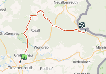
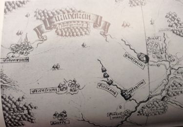
Randonnée A pied de 22 km à découvrir à Bavière, Landkreis Tirschenreuth, Tirschenreuth. Cette randonnée est proposée par SityTrail - itinéraires balisés pédestres.

Description

Randonnée créée par Oberpfälzer Waldverein.

Symbole: Ein rotes Dreieck mit Spitze nach oben auf weißem Hintergrund


Site web: https://wandern-in-neualbenreuth.de/tirschenreuth-wernersreuth-nikolauskirche/

Photos

Localisation

Pays :
Allemagne
Région :
Bavière
Département/Province :
Landkreis Tirschenreuth
Commune :
Tirschenreuth
Localité :
Unknown
Départ:(UTM)
308649 ; 5529207 (33U) N.

Randonnées à proximité

Randonnée A pied Tirschenreuth - Tirschenreuth Rundwanderweg Nr. 10 - Photo
A pied
PRO

A pied

Facile
Tirschenreuth, Bavière, Landkreis Tirschenreuth, Allemagne
6,7 km | 8,2 km-effort
1h 52min
Non
Randonnée A pied Tirschenreuth - Tirschenreuth Rundwanderweg Nr. 9 - Photo
A pied
PRO

A pied

Facile
Tirschenreuth, Bavière, Landkreis Tirschenreuth, Allemagne
11,6 km | 13,8 km-effort
3h 8min
Oui
Randonnée A pied Tirschenreuth - Tirschenreuth Rundwanderweg Nr. 4 - Photo
A pied
PRO

A pied

Facile
Tirschenreuth, Bavière, Landkreis Tirschenreuth, Allemagne
8,3 km | 9,7 km-effort
2h 12min
Oui
Randonnée A pied Tirschenreuth - Tirschenreuth Rundwanderweg Nr. 5 - Photo
A pied
PRO

A pied

Facile
Tirschenreuth, Bavière, Landkreis Tirschenreuth, Allemagne
11,7 km | 14,1 km-effort
3h 12min
Oui
Randonnée A pied Tirschenreuth - Tirschenreuth Rundwanderweg Nr. 3 - Photo
A pied
PRO

A pied

Facile
Tirschenreuth, Bavière, Landkreis Tirschenreuth, Allemagne
10,3 km | 12,8 km-effort
2h 54min
Oui
Randonnée A pied Tirschenreuth - Tirschenreuth Rundwanderweg Nr. 7 - Photo
A pied
PRO

A pied

Facile
Tirschenreuth, Bavière, Landkreis Tirschenreuth, Allemagne
12,8 km | 15,4 km-effort
3h 30min
Oui
Randonnée A pied Tirschenreuth - OWV-Heim, Kl. Teufelsküche - Photo
A pied
PRO

A pied

Facile
Tirschenreuth, Bavière, Landkreis Tirschenreuth, Allemagne
6,3 km | 8,1 km-effort
1h 49min
Non
Randonnée A pied Tirschenreuth - Tirschenreuth Rundwanderweg Nr. 8 - Photo
A pied
PRO

A pied

Facile
Tirschenreuth, Bavière, Landkreis Tirschenreuth, Allemagne
9,1 km | 10,8 km-effort
2h 27min
Non
Randonnée A pied Leonberg - Tirschenreuth Rundwanderweg Nr. 6 - Photo
A pied
PRO

A pied

Facile
Leonberg, Bavière, Landkreis Tirschenreuth, Allemagne
7,4 km | 8,6 km-effort
1h 57min
Non


Fermer
Mes abonnements