![](/images/other/stat-length.png)
![Randonnée A pied Jesteburg - Jesteburg Wanderweg 7 - Photo](https://media.geolcdn.com/t/1900/400/ext.pjpeg?maxdim=2&url=https%3A%2F%2Fstatic1.geolcdn.com%2Fsiteimages%2Fupload%2Ffiles%2F1545311037marcheuse_200dpi.jpg)
Jesteburg Wanderweg 7
SityTrail - itinéraires balisés pédestres
Tous les sentiers balisés d’Europe GUIDE+
![Longueur](/images/other/stat-length.png)
Longueur
3,9 km
![Altitude max](https://static1.geolcdn.com/siteimages/upload/files/1508320355ic_sort_altitude_max_24dp.png)
Altitude max
69 m
![Dénivelé positif](https://static1.geolcdn.com/siteimages/upload/files/1508320355ic_sort_den_pos_24dp.png)
Dénivelé positif
28 m
![Km-Effort](/images/other/stat-length.png)
Km-Effort
4,4 km
![Altitude min](https://static1.geolcdn.com/siteimages/upload/files/1508320355ic_sort_altitude_min_24dp.png)
Altitude min
27 m
![Dénivelé négatif](https://static1.geolcdn.com/siteimages/upload/files/1508320355ic_sort_den_neg_24dp.png)
Dénivelé négatif
44 m
![Boucle](https://static1.geolcdn.com/siteimages/upload/files/16400158638029165_repeat_loop_refresh_sync_direction_icon.png)
Boucle
Non
Balise
Date de création :
2022-02-11 14:29:05.519
Dernière modification :
2022-02-11 14:29:05.519
![A pied](https://static1.geolcdn.com/sitytour/trail-icons/100.png)
59m
Difficulté : Facile
![Scannez ce code QR pour ouvrir la randonnée dans l'application SityTrail](https://capi.geolives.com/qq0zvz2zws4bq2lad0pu/sitytour/trails/3092675/qr.png?size=200)
Application GPS de randonnée GRATUITE
À propos
Randonnée A pied de 3,9 km à découvrir à Basse-Saxe, Harbourg (arrondissement), Jesteburg. Cette randonnée est proposée par SityTrail - itinéraires balisés pédestres.
Description
Randonnée créée par Samtgemeinde Jesteburg.
Symbole: weisse 7 auf rotem Pfeil
Site web: https://www.jesteburg.de/
Localisation
Pays :
Allemagne
Région :
Basse-Saxe
Département/Province :
Harbourg (arrondissement)
Commune :
Jesteburg
Localité :
Unknown
Départ:(Dec)
Départ:(UTM)
561978 ; 5904926 (32U) N.
Commentaires
Randonnées à proximité
![Randonnée A pied Jesteburg - Jesteburg Wanderweg 9 - Photo](https://media.geolcdn.com/t/375/260/7d066065-9c32-4083-b3e8-f88ab126f87f.jpeg&format=jpg&maxdim=2)
![A pied A pied](https://static1.geolcdn.com/sitytour/trail-icons/100.png)
Jesteburg Wanderweg 9
A pied
Facile
Jesteburg,
Basse-Saxe,
Harbourg (arrondissement),
Allemagne
![](/images/other/stat-length.png)
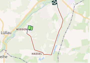
3,7 km | 4 km-effort
54min
![](https://static1.geolcdn.com/siteimages/upload/files/16400158638029165_repeat_loop_refresh_sync_direction_icon.png)
Non
![Randonnée A pied Buchholz in der Nordheide - Buchholzer Rundwanderweg 3 - Photo](https://media.geolcdn.com/t/375/260/28e5ed77-e949-44e9-a047-fc9c80696c7c.jpeg&format=jpg&maxdim=2)
![A pied A pied](https://static1.geolcdn.com/sitytour/trail-icons/100.png)
Buchholzer Rundwanderweg 3
A pied
Facile
Buchholz in der Nordheide,
Basse-Saxe,
Harbourg (arrondissement),
Allemagne
![](/images/other/stat-length.png)
10 km | 11,4 km-effort
2h 35min
![](https://static1.geolcdn.com/siteimages/upload/files/16400158638029165_repeat_loop_refresh_sync_direction_icon.png)
Non
![Randonnée A pied Buchholz in der Nordheide - Ho-Se Blauer Rundwanderweg - Photo](https://media.geolcdn.com/t/375/260/0b1df7cd-3876-47c5-a88e-a4686dce1f3f.jpeg&format=jpg&maxdim=2)
![A pied A pied](https://static1.geolcdn.com/sitytour/trail-icons/100.png)
Ho-Se Blauer Rundwanderweg
A pied
Facile
Buchholz in der Nordheide,
Basse-Saxe,
Harbourg (arrondissement),
Allemagne
![](/images/other/stat-length.png)
9,7 km | 10,8 km-effort
2h 26min
![](https://static1.geolcdn.com/siteimages/upload/files/16400158638029165_repeat_loop_refresh_sync_direction_icon.png)
Non
![Randonnée A pied Buchholz in der Nordheide - Ho-Se Grüner Rundwanderweg - Photo](https://media.geolcdn.com/t/375/260/ae5dea94-e574-463b-9942-e09ffae2ceb4.jpeg&format=jpg&maxdim=2)
![A pied A pied](https://static1.geolcdn.com/sitytour/trail-icons/100.png)
Ho-Se Grüner Rundwanderweg
A pied
Facile
Buchholz in der Nordheide,
Basse-Saxe,
Harbourg (arrondissement),
Allemagne
![](/images/other/stat-length.png)
5,8 km | 6,4 km-effort
1h 27min
![](https://static1.geolcdn.com/siteimages/upload/files/16400158638029165_repeat_loop_refresh_sync_direction_icon.png)
Non
![Randonnée A pied Buchholz in der Nordheide - Ho-Se Roter Rundwanderweg - Photo](https://media.geolcdn.com/t/375/260/276b6fcb-39d4-4545-a436-c142e45b3bc3.jpeg&format=jpg&maxdim=2)
![A pied A pied](https://static1.geolcdn.com/sitytour/trail-icons/100.png)
Ho-Se Roter Rundwanderweg
A pied
Facile
Buchholz in der Nordheide,
Basse-Saxe,
Harbourg (arrondissement),
Allemagne
![](/images/other/stat-length.png)
7,9 km | 9,3 km-effort
2h 6min
![](https://static1.geolcdn.com/siteimages/upload/files/16400158638029165_repeat_loop_refresh_sync_direction_icon.png)
Oui
![Randonnée A pied Buchholz in der Nordheide - Ho-Se Grauer Rundwanderweg - Photo](https://media.geolcdn.com/t/375/260/9f797c7f-f4f6-44f6-948a-d9eee7a342c9.jpeg&format=jpg&maxdim=2)
![A pied A pied](https://static1.geolcdn.com/sitytour/trail-icons/100.png)
Ho-Se Grauer Rundwanderweg
A pied
Facile
Buchholz in der Nordheide,
Basse-Saxe,
Harbourg (arrondissement),
Allemagne
![](/images/other/stat-length.png)
8,2 km | 9,2 km-effort
2h 4min
![](https://static1.geolcdn.com/siteimages/upload/files/16400158638029165_repeat_loop_refresh_sync_direction_icon.png)
Oui
![Randonnée A pied Buchholz in der Nordheide - Ho-Se Gelber Rundwanderweg - Photo](https://media.geolcdn.com/t/375/260/0b1df7cd-3876-47c5-a88e-a4686dce1f3f.jpeg&format=jpg&maxdim=2)
![A pied A pied](https://static1.geolcdn.com/sitytour/trail-icons/100.png)
Ho-Se Gelber Rundwanderweg
A pied
Facile
Buchholz in der Nordheide,
Basse-Saxe,
Harbourg (arrondissement),
Allemagne
![](/images/other/stat-length.png)
4,5 km | 4,9 km-effort
1h 7min
![](https://static1.geolcdn.com/siteimages/upload/files/16400158638029165_repeat_loop_refresh_sync_direction_icon.png)
Oui
![Randonnée A pied Hanstedt - Nordic Walking 3L Hanstedt - Photo](https://media.geolcdn.com/t/375/260/13bb3500-164e-4ef3-88ad-9ad587cc613d.jpeg&format=jpg&maxdim=2)
![A pied A pied](https://static1.geolcdn.com/sitytour/trail-icons/100.png)
Nordic Walking 3L Hanstedt
A pied
Facile
Hanstedt,
Basse-Saxe,
Harbourg (arrondissement),
Allemagne
![](/images/other/stat-length.png)
4,2 km | 5,1 km-effort
1h 9min
![](https://static1.geolcdn.com/siteimages/upload/files/16400158638029165_repeat_loop_refresh_sync_direction_icon.png)
Non
![Randonnée A pied Hanstedt - Nordic Walking 2M Hanstedt - Photo](https://media.geolcdn.com/t/375/260/13bb3500-164e-4ef3-88ad-9ad587cc613d.jpeg&format=jpg&maxdim=2)
![A pied A pied](https://static1.geolcdn.com/sitytour/trail-icons/100.png)
Nordic Walking 2M Hanstedt
A pied
Facile
Hanstedt,
Basse-Saxe,
Harbourg (arrondissement),
Allemagne
![](/images/other/stat-length.png)
5,1 km | 6,2 km-effort
1h 24min
![](https://static1.geolcdn.com/siteimages/upload/files/16400158638029165_repeat_loop_refresh_sync_direction_icon.png)
Non