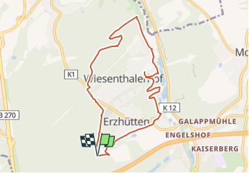
![](/images/other/stat-length.png)
![Randonnée A pied Unknown - Hütterer Rundwanderweg Ost - Photo](https://media.geolcdn.com/t/1900/400/c85501c2-505e-47aa-aaf2-be9bbbb67824.jpeg&format=pjpeg&maxdim=2)
Hütterer Rundwanderweg Ost
SityTrail - itinéraires balisés pédestres
Tous les sentiers balisés d’Europe GUIDE+
![Longueur](/images/other/stat-length.png)
![Altitude max](https://static1.geolcdn.com/siteimages/upload/files/1508320355ic_sort_altitude_max_24dp.png)
![Dénivelé positif](https://static1.geolcdn.com/siteimages/upload/files/1508320355ic_sort_den_pos_24dp.png)
![Km-Effort](/images/other/stat-length.png)
![Altitude min](https://static1.geolcdn.com/siteimages/upload/files/1508320355ic_sort_altitude_min_24dp.png)
![Dénivelé négatif](https://static1.geolcdn.com/siteimages/upload/files/1508320355ic_sort_den_neg_24dp.png)
![Boucle](https://static1.geolcdn.com/siteimages/upload/files/16400158638029165_repeat_loop_refresh_sync_direction_icon.png)
![A pied](https://static1.geolcdn.com/sitytour/trail-icons/100.png)
2h19
Difficulté : Facile
![Scannez ce code QR pour ouvrir la randonnée dans l'application SityTrail](https://capi.geolives.com/qq0zvz2zws4bq2lad0pu/sitytour/trails/3092634/qr.png?size=200)
Application GPS de randonnée GRATUITE
À propos
Randonnée A pied de 8 km à découvrir à Rhénanie-Palatinat, Kaiserslautern. Cette randonnée est proposée par SityTrail - itinéraires balisés pédestres.
Description
Randonnée créée par Heimatverein Erzhütten-Wiesenthalerhof.
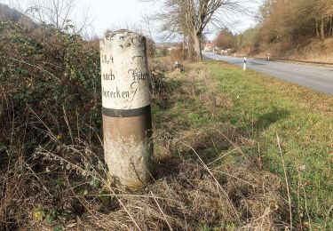
Für die beiden Seitenäste wurde eine Anfrage an den Hütterer Rundwanderweg gestellt (2018-09-13)
Symbole: Schlägel und Eisen
Site web: http://hv-erzhütten.de/wanderwege-rund-um-erzhuettenwiesenthalerhof
Localisation
Commentaires
Randonnées à proximité
![Randonnée A pied - Wanderweg Erfenach 4, Rund um den Maienberg - Photo](https://media.geolcdn.com/t/375/260/ca6e4dd2-da62-4ca4-9bf9-cdb07d398274.jpeg&format=jpg&maxdim=2)
![A pied A pied](https://static1.geolcdn.com/sitytour/trail-icons/100.png)
A pied
![](/images/other/stat-length.png)
![](https://static1.geolcdn.com/siteimages/upload/files/16400158638029165_repeat_loop_refresh_sync_direction_icon.png)
![Randonnée A pied - Wanderweg Erfenach 3, Maienberg - Photo](https://media.geolcdn.com/t/375/260/c85501c2-505e-47aa-aaf2-be9bbbb67824.jpeg&format=jpg&maxdim=2)
![A pied A pied](https://static1.geolcdn.com/sitytour/trail-icons/100.png)
A pied
![](/images/other/stat-length.png)
![](https://static1.geolcdn.com/siteimages/upload/files/16400158638029165_repeat_loop_refresh_sync_direction_icon.png)
![Randonnée A pied - Waldlaufparcours Kaiserslautern Rot - Photo](https://media.geolcdn.com/t/375/260/2c86c5a9-51e6-44c5-84fc-a5af71b84ba4.jpeg&format=jpg&maxdim=2)
![A pied A pied](https://static1.geolcdn.com/sitytour/trail-icons/100.png)
A pied
![](/images/other/stat-length.png)
![](https://static1.geolcdn.com/siteimages/upload/files/16400158638029165_repeat_loop_refresh_sync_direction_icon.png)
![Randonnée A pied - Waldlaufparcours Kaiserslautern Blau - Photo](https://media.geolcdn.com/t/375/260/2c86c5a9-51e6-44c5-84fc-a5af71b84ba4.jpeg&format=jpg&maxdim=2)
![A pied A pied](https://static1.geolcdn.com/sitytour/trail-icons/100.png)
A pied
![](/images/other/stat-length.png)
![](https://static1.geolcdn.com/siteimages/upload/files/16400158638029165_repeat_loop_refresh_sync_direction_icon.png)
![Randonnée A pied - Rundwanderweg 2, Wiesenthalerhof - Photo](https://media.geolcdn.com/t/375/260/2c86c5a9-51e6-44c5-84fc-a5af71b84ba4.jpeg&format=jpg&maxdim=2)
![A pied A pied](https://static1.geolcdn.com/sitytour/trail-icons/100.png)
A pied
![](/images/other/stat-length.png)
![](https://static1.geolcdn.com/siteimages/upload/files/16400158638029165_repeat_loop_refresh_sync_direction_icon.png)
![Randonnée A pied - Hütterer Rundwanderweg West - Photo](https://media.geolcdn.com/t/375/260/2c86c5a9-51e6-44c5-84fc-a5af71b84ba4.jpeg&format=jpg&maxdim=2)
![A pied A pied](https://static1.geolcdn.com/sitytour/trail-icons/100.png)
A pied
![](/images/other/stat-length.png)
![](https://static1.geolcdn.com/siteimages/upload/files/16400158638029165_repeat_loop_refresh_sync_direction_icon.png)
![Randonnée A pied - Waldlaufparcours Kaiserslautern Gelb - Photo](https://media.geolcdn.com/t/375/260/2c86c5a9-51e6-44c5-84fc-a5af71b84ba4.jpeg&format=jpg&maxdim=2)
![A pied A pied](https://static1.geolcdn.com/sitytour/trail-icons/100.png)
A pied
![](/images/other/stat-length.png)
![](https://static1.geolcdn.com/siteimages/upload/files/16400158638029165_repeat_loop_refresh_sync_direction_icon.png)
![Randonnée A pied - Waldlaufparcours Vogelwoog Grün - Photo](https://media.geolcdn.com/t/375/260/b825c54d-9a33-4df3-b09c-10dc316b7c86.jpeg&format=jpg&maxdim=2)
![A pied A pied](https://static1.geolcdn.com/sitytour/trail-icons/100.png)
A pied
![](/images/other/stat-length.png)
![](https://static1.geolcdn.com/siteimages/upload/files/16400158638029165_repeat_loop_refresh_sync_direction_icon.png)
![Randonnée A pied - Waldlehrpfad Bremerhof - Photo](https://media.geolcdn.com/t/375/260/cb187164-1030-4d9a-83ce-e8d9cc989f4c.jpeg&format=jpg&maxdim=2)
![A pied A pied](https://static1.geolcdn.com/sitytour/trail-icons/100.png)
A pied
![](/images/other/stat-length.png)
![](https://static1.geolcdn.com/siteimages/upload/files/16400158638029165_repeat_loop_refresh_sync_direction_icon.png)