![](/images/other/stat-length.png)
![Randonnée A pied Naumburg - Habichtswaldsteig - Extratour Naumburg - Photo](https://media.geolcdn.com/t/1900/400/ext.pjpeg?maxdim=2&url=https%3A%2F%2Fstatic1.geolcdn.com%2Fsiteimages%2Fupload%2Ffiles%2F1545311037marcheuse_200dpi.jpg)
Habichtswaldsteig - Extratour Naumburg
SityTrail - itinéraires balisés pédestres
Tous les sentiers balisés d’Europe GUIDE+
![Longueur](/images/other/stat-length.png)
![Altitude max](https://static1.geolcdn.com/siteimages/upload/files/1508320355ic_sort_altitude_max_24dp.png)
![Dénivelé positif](https://static1.geolcdn.com/siteimages/upload/files/1508320355ic_sort_den_pos_24dp.png)
![Km-Effort](/images/other/stat-length.png)
![Altitude min](https://static1.geolcdn.com/siteimages/upload/files/1508320355ic_sort_altitude_min_24dp.png)
![Dénivelé négatif](https://static1.geolcdn.com/siteimages/upload/files/1508320355ic_sort_den_neg_24dp.png)
![Boucle](https://static1.geolcdn.com/siteimages/upload/files/16400158638029165_repeat_loop_refresh_sync_direction_icon.png)
![A pied](https://static1.geolcdn.com/sitytour/trail-icons/100.png)
4h44
Difficulté : Moyen
![Scannez ce code QR pour ouvrir la randonnée dans l'application SityTrail](https://capi.geolives.com/qq0zvz2zws4bq2lad0pu/sitytour/trails/3092303/qr.png?size=200)
Application GPS de randonnée GRATUITE
À propos
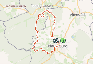
Randonnée A pied de 15,2 km à découvrir à Hesse, Landkreis Kassel, Naumburg. Cette randonnée est proposée par SityTrail - itinéraires balisés pédestres.
Description
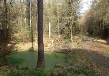
Es sind die Reste der gräflichen Naumburg und die legendäre Weidelsburg, die die Extratour durch das Tal der Elbe verbindet. Der Wanderer entdeckt das Mittelalter, als Sagen und Märchen nach Erklärungen suchten, um dann im Hier und Jetzt eine lebendige und abwechslungsreiche Kulturlandschaft zu erleben.
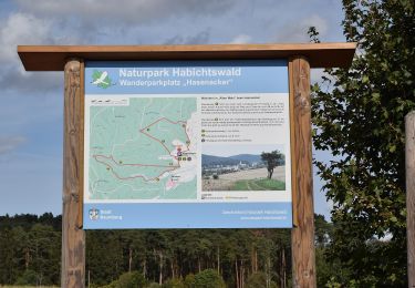
Site web: https://www.naturpark-habichtswald.de/touren/h8-im-tal-der-zwei-burgen
Localisation
Commentaires
Randonnées à proximité
![Randonnée A pied Edertal - Böhne 1 (Bö1) - Photo](https://media.geolcdn.com/t/375/260/8a104d4f-159a-4f1a-98f9-cf725a9b879d.jpeg&format=jpg&maxdim=2)
![A pied A pied](https://static1.geolcdn.com/sitytour/trail-icons/100.png)
A pied
![](/images/other/stat-length.png)
![](https://static1.geolcdn.com/siteimages/upload/files/16400158638029165_repeat_loop_refresh_sync_direction_icon.png)
![Randonnée A pied Naumburg - Bonifatiuspfad Abschnitt 4, - Naumburg - Fritzlar - Photo](https://media.geolcdn.com/t/375/260/feeede37-eb8d-4658-8bf5-e0c9f59e87a5.jpeg&format=jpg&maxdim=2)
![A pied A pied](https://static1.geolcdn.com/sitytour/trail-icons/100.png)
A pied
![](/images/other/stat-length.png)
![](https://static1.geolcdn.com/siteimages/upload/files/16400158638029165_repeat_loop_refresh_sync_direction_icon.png)
![Randonnée A pied Naumburg - Naumburg-Elbenberg - E3 - Photo](https://media.geolcdn.com/t/375/260/f46b84e6-0b0a-4b9f-bada-5d742549cd4f.jpeg&format=jpg&maxdim=2)
![A pied A pied](https://static1.geolcdn.com/sitytour/trail-icons/100.png)
A pied
![](/images/other/stat-length.png)
![](https://static1.geolcdn.com/siteimages/upload/files/16400158638029165_repeat_loop_refresh_sync_direction_icon.png)
![Randonnée A pied Naumburg - Naumburg - N5 - Photo](https://media.geolcdn.com/t/375/260/feeede37-eb8d-4658-8bf5-e0c9f59e87a5.jpeg&format=jpg&maxdim=2)
![A pied A pied](https://static1.geolcdn.com/sitytour/trail-icons/100.png)
A pied
![](/images/other/stat-length.png)
![](https://static1.geolcdn.com/siteimages/upload/files/16400158638029165_repeat_loop_refresh_sync_direction_icon.png)
![Randonnée A pied Naumburg - Naumburg - N2 - Photo](https://media.geolcdn.com/t/375/260/7b42d138-2d5b-4659-b05b-723024f38f78.jpeg&format=jpg&maxdim=2)
![A pied A pied](https://static1.geolcdn.com/sitytour/trail-icons/100.png)
A pied
![](/images/other/stat-length.png)
![](https://static1.geolcdn.com/siteimages/upload/files/16400158638029165_repeat_loop_refresh_sync_direction_icon.png)
![Randonnée A pied Naumburg - Naumburg - N3 - Photo](https://media.geolcdn.com/t/375/260/640338f4-2c05-40e1-b425-b130f687b287.jpeg&format=jpg&maxdim=2)
![A pied A pied](https://static1.geolcdn.com/sitytour/trail-icons/100.png)
A pied
![](/images/other/stat-length.png)
![](https://static1.geolcdn.com/siteimages/upload/files/16400158638029165_repeat_loop_refresh_sync_direction_icon.png)
![Randonnée A pied Naumburg - Naumburg - N9 - Photo](https://media.geolcdn.com/t/375/260/0bce6518-29ab-48a9-be2b-8f302274b1b9.jpeg&format=jpg&maxdim=2)
![A pied A pied](https://static1.geolcdn.com/sitytour/trail-icons/100.png)
A pied
![](/images/other/stat-length.png)
![](https://static1.geolcdn.com/siteimages/upload/files/16400158638029165_repeat_loop_refresh_sync_direction_icon.png)
![Randonnée A pied Naumburg - Naumburg - N1 - Photo](https://media.geolcdn.com/t/375/260/7351aa95-b073-4f73-b529-61caadcaf797.jpeg&format=jpg&maxdim=2)
![A pied A pied](https://static1.geolcdn.com/sitytour/trail-icons/100.png)
A pied
![](/images/other/stat-length.png)
![](https://static1.geolcdn.com/siteimages/upload/files/16400158638029165_repeat_loop_refresh_sync_direction_icon.png)
![Randonnée A pied Wolfhagen - Weidelsburg, Rundweg 2 - Photo](https://media.geolcdn.com/t/375/260/bbb36430-7c0e-4502-80bd-707f94c61de1.jpeg&format=jpg&maxdim=2)
![A pied A pied](https://static1.geolcdn.com/sitytour/trail-icons/100.png)
A pied
![](/images/other/stat-length.png)
![](https://static1.geolcdn.com/siteimages/upload/files/16400158638029165_repeat_loop_refresh_sync_direction_icon.png)