![](/images/other/stat-length.png)
![Randonnée A pied Gutsbezirk Kaufunger Wald - Großalmerode, Rundweg 6 - Photo](https://media.geolcdn.com/t/1900/400/8e5ec378-ed97-4358-a3a6-369eb3821eb2.jpeg&format=pjpeg&maxdim=2)
Großalmerode, Rundweg 6
SityTrail - itinéraires balisés pédestres
Tous les sentiers balisés d’Europe GUIDE+
![Longueur](/images/other/stat-length.png)
Longueur
7,8 km
![Altitude max](https://static1.geolcdn.com/siteimages/upload/files/1508320355ic_sort_altitude_max_24dp.png)
Altitude max
642 m
![Dénivelé positif](https://static1.geolcdn.com/siteimages/upload/files/1508320355ic_sort_den_pos_24dp.png)
Dénivelé positif
282 m
![Km-Effort](/images/other/stat-length.png)
Km-Effort
11,6 km
![Altitude min](https://static1.geolcdn.com/siteimages/upload/files/1508320355ic_sort_altitude_min_24dp.png)
Altitude min
379 m
![Dénivelé négatif](https://static1.geolcdn.com/siteimages/upload/files/1508320355ic_sort_den_neg_24dp.png)
Dénivelé négatif
285 m
![Boucle](https://static1.geolcdn.com/siteimages/upload/files/16400158638029165_repeat_loop_refresh_sync_direction_icon.png)
Boucle
Oui
Balise
Date de création :
2022-02-11 14:14:44.322
Dernière modification :
2022-02-11 14:14:44.322
![A pied](https://static1.geolcdn.com/sitytour/trail-icons/100.png)
2h37
Difficulté : Facile
![Scannez ce code QR pour ouvrir la randonnée dans l'application SityTrail](https://capi.geolives.com/qq0zvz2zws4bq2lad0pu/sitytour/trails/3092280/qr.png?size=200)
Application GPS de randonnée GRATUITE
À propos
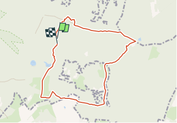
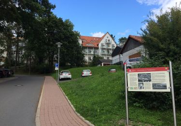
Randonnée A pied de 7,8 km à découvrir à Hesse, Werra-Meißner-Kreis, Gutsbezirk Kaufunger Wald. Cette randonnée est proposée par SityTrail - itinéraires balisés pédestres.
Description
Wanderweg wird von der Stadt Großalmerode nicht mehr gepflegt
Localisation
Pays :
Allemagne
Région :
Hesse
Département/Province :
Werra-Meißner-Kreis
Commune :
Gutsbezirk Kaufunger Wald
Localité :
Unknown
Départ:(Dec)
Départ:(UTM)
554614 ; 5681357 (32U) N.
Commentaires
Randonnées à proximité
![Randonnée A pied Gutsbezirk Kaufunger Wald - Großalmerode, Rundweg 18 - Photo](https://media.geolcdn.com/t/375/260/a7004925-fa01-44e0-88fb-d4fe5055ba10.jpeg&format=jpg&maxdim=2)
![A pied A pied](https://static1.geolcdn.com/sitytour/trail-icons/100.png)
Großalmerode, Rundweg 18
A pied
Facile
Gutsbezirk Kaufunger Wald,
Hesse,
Werra-Meißner-Kreis,
Allemagne
![](/images/other/stat-length.png)
8,9 km | 14,4 km-effort
3h 16min
![](https://static1.geolcdn.com/siteimages/upload/files/16400158638029165_repeat_loop_refresh_sync_direction_icon.png)
Oui
![Randonnée A pied Großalmerode - Großalmerode, Rundweg 2 - Photo](https://media.geolcdn.com/t/375/260/4365a2ae-62cb-4ee3-b193-b3566a377c49.jpeg&format=jpg&maxdim=2)
![A pied A pied](https://static1.geolcdn.com/sitytour/trail-icons/100.png)
Großalmerode, Rundweg 2
A pied
Facile
Großalmerode,
Hesse,
Werra-Meißner-Kreis,
Allemagne
![](/images/other/stat-length.png)
6,2 km | 8,7 km-effort
1h 58min
![](https://static1.geolcdn.com/siteimages/upload/files/16400158638029165_repeat_loop_refresh_sync_direction_icon.png)
Oui
![Randonnée A pied Helsa - Kaufunger Wald, Rundweg 23 - Photo](https://media.geolcdn.com/t/375/260/e706d2be-6dcb-45d5-9380-5104885f2f7f.jpeg&format=jpg&maxdim=2)
![A pied A pied](https://static1.geolcdn.com/sitytour/trail-icons/100.png)
Kaufunger Wald, Rundweg 23
A pied
Facile
Helsa,
Hesse,
Landkreis Kassel,
Allemagne
![](/images/other/stat-length.png)
8,3 km | 11,6 km-effort
2h 38min
![](https://static1.geolcdn.com/siteimages/upload/files/16400158638029165_repeat_loop_refresh_sync_direction_icon.png)
Oui
![Randonnée A pied Gutsbezirk Kaufunger Wald - Rundweg Lichte Eiche - Photo](https://media.geolcdn.com/t/375/260/3ac3c368-0e25-46b5-9532-d254f296aa87.jpeg&format=jpg&maxdim=2)
![A pied A pied](https://static1.geolcdn.com/sitytour/trail-icons/100.png)
Rundweg Lichte Eiche
A pied
Facile
Gutsbezirk Kaufunger Wald,
Hesse,
Werra-Meißner-Kreis,
Allemagne
![](/images/other/stat-length.png)
4,3 km | 5,9 km-effort
1h 20min
![](https://static1.geolcdn.com/siteimages/upload/files/16400158638029165_repeat_loop_refresh_sync_direction_icon.png)
Oui
![Randonnée A pied Witzenhausen - Bilsteinrundweg - Photo](https://media.geolcdn.com/t/375/260/3ac3c368-0e25-46b5-9532-d254f296aa87.jpeg&format=jpg&maxdim=2)
![A pied A pied](https://static1.geolcdn.com/sitytour/trail-icons/100.png)
Bilsteinrundweg
A pied
Facile
Witzenhausen,
Hesse,
Werra-Meißner-Kreis,
Allemagne
![](/images/other/stat-length.png)
8,5 km | 13 km-effort
2h 57min
![](https://static1.geolcdn.com/siteimages/upload/files/16400158638029165_repeat_loop_refresh_sync_direction_icon.png)
Oui
![Randonnée A pied Gutsbezirk Kaufunger Wald - Premiumweg P 9 Wacholderpfad - Photo](https://media.geolcdn.com/t/375/260/3c9bcb46-4b4e-4240-9193-c859e04ccd2c.jpeg&format=jpg&maxdim=2)
![A pied A pied](https://static1.geolcdn.com/sitytour/trail-icons/100.png)
Premiumweg P 9 Wacholderpfad
A pied
Facile
Gutsbezirk Kaufunger Wald,
Hesse,
Werra-Meißner-Kreis,
Allemagne
![](/images/other/stat-length.png)
10,7 km | 15,1 km-effort
3h 25min
![](https://static1.geolcdn.com/siteimages/upload/files/16400158638029165_repeat_loop_refresh_sync_direction_icon.png)
Oui
![Randonnée A pied Großalmerode - Rundweg Heiligenberg - Dudenrode - Photo](https://media.geolcdn.com/t/375/260/8f0ba73b-89d7-4da8-9a04-806bb6f75cd7.jpeg&format=jpg&maxdim=2)
![A pied A pied](https://static1.geolcdn.com/sitytour/trail-icons/100.png)
Rundweg Heiligenberg - Dudenrode
A pied
Facile
Großalmerode,
Hesse,
Werra-Meißner-Kreis,
Allemagne
![](/images/other/stat-length.png)
9,7 km | 14,4 km-effort
3h 16min
![](https://static1.geolcdn.com/siteimages/upload/files/16400158638029165_repeat_loop_refresh_sync_direction_icon.png)
Oui
![Randonnée A pied Großalmerode - Premiumweg Heiligenberg Rundweg - Photo](https://media.geolcdn.com/t/375/260/8f0ba73b-89d7-4da8-9a04-806bb6f75cd7.jpeg&format=jpg&maxdim=2)
![A pied A pied](https://static1.geolcdn.com/sitytour/trail-icons/100.png)
Premiumweg Heiligenberg Rundweg
A pied
Facile
Großalmerode,
Hesse,
Werra-Meißner-Kreis,
Allemagne
![](/images/other/stat-length.png)
7 km | 9,9 km-effort
2h 14min
![](https://static1.geolcdn.com/siteimages/upload/files/16400158638029165_repeat_loop_refresh_sync_direction_icon.png)
Oui
![Randonnée A pied Gutsbezirk Kaufunger Wald - Kaufunger Wald, Rundweg 11 - Steinberg - Photo](https://media.geolcdn.com/t/375/260/8e5ec378-ed97-4358-a3a6-369eb3821eb2.jpeg&format=jpg&maxdim=2)
![A pied A pied](https://static1.geolcdn.com/sitytour/trail-icons/100.png)
Kaufunger Wald, Rundweg 11 - Steinberg
A pied
Facile
Gutsbezirk Kaufunger Wald,
Hesse,
Werra-Meißner-Kreis,
Allemagne
![](/images/other/stat-length.png)
6,5 km | 8,9 km-effort
2h 1min
![](https://static1.geolcdn.com/siteimages/upload/files/16400158638029165_repeat_loop_refresh_sync_direction_icon.png)
Oui