


12 km | 15,6 km-effort

Tous les sentiers balisés d’Europe GUIDE+


Application GPS de randonnée GRATUITE
 SityTrail
IGN / Instituts géographiques
SityTrail World
Le monde est à vous
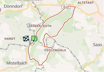
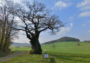
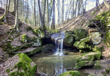
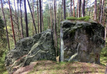
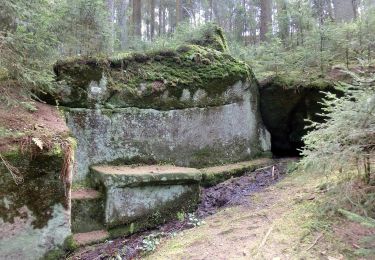
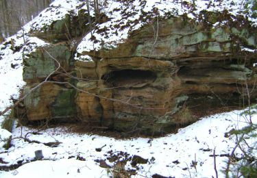
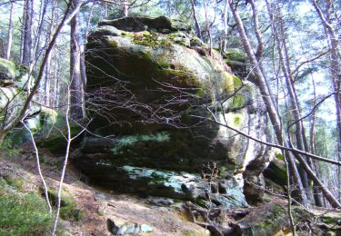
Randonnée A pied de 7,9 km à découvrir à Bavière, Landkreis Bayreuth, Eckersdorf. Cette randonnée est proposée par SityTrail - itinéraires balisés pédestres.
Randonnée créée par Wanderfreunde Mistelbach.
Symbole: blauer Ring
 "
data-pinterest-text="Pin it"
data-tweet-text="share on twitter"
data-facebook-share-url="https://www.sitytrail.com/fr/trails/3092124-eckersdorf--mistelbach-rundwanderweg-xdurch-die-mistelauenx/?photo=1#lg=1&slide=1"
data-twitter-share-url="https://www.sitytrail.com/fr/trails/3092124-eckersdorf--mistelbach-rundwanderweg-xdurch-die-mistelauenx/?photo=1#lg=1&slide=1"
data-googleplus-share-url="https://www.sitytrail.com/fr/trails/3092124-eckersdorf--mistelbach-rundwanderweg-xdurch-die-mistelauenx/?photo=1#lg=1&slide=1"
data-pinterest-share-url="https://www.sitytrail.com/fr/trails/3092124-eckersdorf--mistelbach-rundwanderweg-xdurch-die-mistelauenx/?photo=1#lg=1&slide=1">
"
data-pinterest-text="Pin it"
data-tweet-text="share on twitter"
data-facebook-share-url="https://www.sitytrail.com/fr/trails/3092124-eckersdorf--mistelbach-rundwanderweg-xdurch-die-mistelauenx/?photo=1#lg=1&slide=1"
data-twitter-share-url="https://www.sitytrail.com/fr/trails/3092124-eckersdorf--mistelbach-rundwanderweg-xdurch-die-mistelauenx/?photo=1#lg=1&slide=1"
data-googleplus-share-url="https://www.sitytrail.com/fr/trails/3092124-eckersdorf--mistelbach-rundwanderweg-xdurch-die-mistelauenx/?photo=1#lg=1&slide=1"
data-pinterest-share-url="https://www.sitytrail.com/fr/trails/3092124-eckersdorf--mistelbach-rundwanderweg-xdurch-die-mistelauenx/?photo=1#lg=1&slide=1">
 "
data-pinterest-text="Pin it"
data-tweet-text="share on twitter"
data-facebook-share-url="https://www.sitytrail.com/fr/trails/3092124-eckersdorf--mistelbach-rundwanderweg-xdurch-die-mistelauenx/?photo=2#lg=1&slide=2"
data-twitter-share-url="https://www.sitytrail.com/fr/trails/3092124-eckersdorf--mistelbach-rundwanderweg-xdurch-die-mistelauenx/?photo=2#lg=1&slide=2"
data-googleplus-share-url="https://www.sitytrail.com/fr/trails/3092124-eckersdorf--mistelbach-rundwanderweg-xdurch-die-mistelauenx/?photo=2#lg=1&slide=2"
data-pinterest-share-url="https://www.sitytrail.com/fr/trails/3092124-eckersdorf--mistelbach-rundwanderweg-xdurch-die-mistelauenx/?photo=2#lg=1&slide=2">
"
data-pinterest-text="Pin it"
data-tweet-text="share on twitter"
data-facebook-share-url="https://www.sitytrail.com/fr/trails/3092124-eckersdorf--mistelbach-rundwanderweg-xdurch-die-mistelauenx/?photo=2#lg=1&slide=2"
data-twitter-share-url="https://www.sitytrail.com/fr/trails/3092124-eckersdorf--mistelbach-rundwanderweg-xdurch-die-mistelauenx/?photo=2#lg=1&slide=2"
data-googleplus-share-url="https://www.sitytrail.com/fr/trails/3092124-eckersdorf--mistelbach-rundwanderweg-xdurch-die-mistelauenx/?photo=2#lg=1&slide=2"
data-pinterest-share-url="https://www.sitytrail.com/fr/trails/3092124-eckersdorf--mistelbach-rundwanderweg-xdurch-die-mistelauenx/?photo=2#lg=1&slide=2">
 "
data-pinterest-text="Pin it"
data-tweet-text="share on twitter"
data-facebook-share-url="https://www.sitytrail.com/fr/trails/3092124-eckersdorf--mistelbach-rundwanderweg-xdurch-die-mistelauenx/?photo=3#lg=1&slide=3"
data-twitter-share-url="https://www.sitytrail.com/fr/trails/3092124-eckersdorf--mistelbach-rundwanderweg-xdurch-die-mistelauenx/?photo=3#lg=1&slide=3"
data-googleplus-share-url="https://www.sitytrail.com/fr/trails/3092124-eckersdorf--mistelbach-rundwanderweg-xdurch-die-mistelauenx/?photo=3#lg=1&slide=3"
data-pinterest-share-url="https://www.sitytrail.com/fr/trails/3092124-eckersdorf--mistelbach-rundwanderweg-xdurch-die-mistelauenx/?photo=3#lg=1&slide=3">
"
data-pinterest-text="Pin it"
data-tweet-text="share on twitter"
data-facebook-share-url="https://www.sitytrail.com/fr/trails/3092124-eckersdorf--mistelbach-rundwanderweg-xdurch-die-mistelauenx/?photo=3#lg=1&slide=3"
data-twitter-share-url="https://www.sitytrail.com/fr/trails/3092124-eckersdorf--mistelbach-rundwanderweg-xdurch-die-mistelauenx/?photo=3#lg=1&slide=3"
data-googleplus-share-url="https://www.sitytrail.com/fr/trails/3092124-eckersdorf--mistelbach-rundwanderweg-xdurch-die-mistelauenx/?photo=3#lg=1&slide=3"
data-pinterest-share-url="https://www.sitytrail.com/fr/trails/3092124-eckersdorf--mistelbach-rundwanderweg-xdurch-die-mistelauenx/?photo=3#lg=1&slide=3">
 "
data-pinterest-text="Pin it"
data-tweet-text="share on twitter"
data-facebook-share-url="https://www.sitytrail.com/fr/trails/3092124-eckersdorf--mistelbach-rundwanderweg-xdurch-die-mistelauenx/?photo=4#lg=1&slide=4"
data-twitter-share-url="https://www.sitytrail.com/fr/trails/3092124-eckersdorf--mistelbach-rundwanderweg-xdurch-die-mistelauenx/?photo=4#lg=1&slide=4"
data-googleplus-share-url="https://www.sitytrail.com/fr/trails/3092124-eckersdorf--mistelbach-rundwanderweg-xdurch-die-mistelauenx/?photo=4#lg=1&slide=4"
data-pinterest-share-url="https://www.sitytrail.com/fr/trails/3092124-eckersdorf--mistelbach-rundwanderweg-xdurch-die-mistelauenx/?photo=4#lg=1&slide=4">
"
data-pinterest-text="Pin it"
data-tweet-text="share on twitter"
data-facebook-share-url="https://www.sitytrail.com/fr/trails/3092124-eckersdorf--mistelbach-rundwanderweg-xdurch-die-mistelauenx/?photo=4#lg=1&slide=4"
data-twitter-share-url="https://www.sitytrail.com/fr/trails/3092124-eckersdorf--mistelbach-rundwanderweg-xdurch-die-mistelauenx/?photo=4#lg=1&slide=4"
data-googleplus-share-url="https://www.sitytrail.com/fr/trails/3092124-eckersdorf--mistelbach-rundwanderweg-xdurch-die-mistelauenx/?photo=4#lg=1&slide=4"
data-pinterest-share-url="https://www.sitytrail.com/fr/trails/3092124-eckersdorf--mistelbach-rundwanderweg-xdurch-die-mistelauenx/?photo=4#lg=1&slide=4">
 "
data-pinterest-text="Pin it"
data-tweet-text="share on twitter"
data-facebook-share-url="https://www.sitytrail.com/fr/trails/3092124-eckersdorf--mistelbach-rundwanderweg-xdurch-die-mistelauenx/?photo=5#lg=1&slide=5"
data-twitter-share-url="https://www.sitytrail.com/fr/trails/3092124-eckersdorf--mistelbach-rundwanderweg-xdurch-die-mistelauenx/?photo=5#lg=1&slide=5"
data-googleplus-share-url="https://www.sitytrail.com/fr/trails/3092124-eckersdorf--mistelbach-rundwanderweg-xdurch-die-mistelauenx/?photo=5#lg=1&slide=5"
data-pinterest-share-url="https://www.sitytrail.com/fr/trails/3092124-eckersdorf--mistelbach-rundwanderweg-xdurch-die-mistelauenx/?photo=5#lg=1&slide=5">
"
data-pinterest-text="Pin it"
data-tweet-text="share on twitter"
data-facebook-share-url="https://www.sitytrail.com/fr/trails/3092124-eckersdorf--mistelbach-rundwanderweg-xdurch-die-mistelauenx/?photo=5#lg=1&slide=5"
data-twitter-share-url="https://www.sitytrail.com/fr/trails/3092124-eckersdorf--mistelbach-rundwanderweg-xdurch-die-mistelauenx/?photo=5#lg=1&slide=5"
data-googleplus-share-url="https://www.sitytrail.com/fr/trails/3092124-eckersdorf--mistelbach-rundwanderweg-xdurch-die-mistelauenx/?photo=5#lg=1&slide=5"
data-pinterest-share-url="https://www.sitytrail.com/fr/trails/3092124-eckersdorf--mistelbach-rundwanderweg-xdurch-die-mistelauenx/?photo=5#lg=1&slide=5">
 "
data-pinterest-text="Pin it"
data-tweet-text="share on twitter"
data-facebook-share-url="https://www.sitytrail.com/fr/trails/3092124-eckersdorf--mistelbach-rundwanderweg-xdurch-die-mistelauenx/?photo=6#lg=1&slide=6"
data-twitter-share-url="https://www.sitytrail.com/fr/trails/3092124-eckersdorf--mistelbach-rundwanderweg-xdurch-die-mistelauenx/?photo=6#lg=1&slide=6"
data-googleplus-share-url="https://www.sitytrail.com/fr/trails/3092124-eckersdorf--mistelbach-rundwanderweg-xdurch-die-mistelauenx/?photo=6#lg=1&slide=6"
data-pinterest-share-url="https://www.sitytrail.com/fr/trails/3092124-eckersdorf--mistelbach-rundwanderweg-xdurch-die-mistelauenx/?photo=6#lg=1&slide=6">
"
data-pinterest-text="Pin it"
data-tweet-text="share on twitter"
data-facebook-share-url="https://www.sitytrail.com/fr/trails/3092124-eckersdorf--mistelbach-rundwanderweg-xdurch-die-mistelauenx/?photo=6#lg=1&slide=6"
data-twitter-share-url="https://www.sitytrail.com/fr/trails/3092124-eckersdorf--mistelbach-rundwanderweg-xdurch-die-mistelauenx/?photo=6#lg=1&slide=6"
data-googleplus-share-url="https://www.sitytrail.com/fr/trails/3092124-eckersdorf--mistelbach-rundwanderweg-xdurch-die-mistelauenx/?photo=6#lg=1&slide=6"
data-pinterest-share-url="https://www.sitytrail.com/fr/trails/3092124-eckersdorf--mistelbach-rundwanderweg-xdurch-die-mistelauenx/?photo=6#lg=1&slide=6">
 "
data-pinterest-text="Pin it"
data-tweet-text="share on twitter"
data-facebook-share-url="https://www.sitytrail.com/fr/trails/3092124-eckersdorf--mistelbach-rundwanderweg-xdurch-die-mistelauenx/?photo=7#lg=1&slide=7"
data-twitter-share-url="https://www.sitytrail.com/fr/trails/3092124-eckersdorf--mistelbach-rundwanderweg-xdurch-die-mistelauenx/?photo=7#lg=1&slide=7"
data-googleplus-share-url="https://www.sitytrail.com/fr/trails/3092124-eckersdorf--mistelbach-rundwanderweg-xdurch-die-mistelauenx/?photo=7#lg=1&slide=7"
data-pinterest-share-url="https://www.sitytrail.com/fr/trails/3092124-eckersdorf--mistelbach-rundwanderweg-xdurch-die-mistelauenx/?photo=7#lg=1&slide=7">
"
data-pinterest-text="Pin it"
data-tweet-text="share on twitter"
data-facebook-share-url="https://www.sitytrail.com/fr/trails/3092124-eckersdorf--mistelbach-rundwanderweg-xdurch-die-mistelauenx/?photo=7#lg=1&slide=7"
data-twitter-share-url="https://www.sitytrail.com/fr/trails/3092124-eckersdorf--mistelbach-rundwanderweg-xdurch-die-mistelauenx/?photo=7#lg=1&slide=7"
data-googleplus-share-url="https://www.sitytrail.com/fr/trails/3092124-eckersdorf--mistelbach-rundwanderweg-xdurch-die-mistelauenx/?photo=7#lg=1&slide=7"
data-pinterest-share-url="https://www.sitytrail.com/fr/trails/3092124-eckersdorf--mistelbach-rundwanderweg-xdurch-die-mistelauenx/?photo=7#lg=1&slide=7">
 "
data-pinterest-text="Pin it"
data-tweet-text="share on twitter"
data-facebook-share-url="https://www.sitytrail.com/fr/trails/3092124-eckersdorf--mistelbach-rundwanderweg-xdurch-die-mistelauenx/?photo=8#lg=1&slide=8"
data-twitter-share-url="https://www.sitytrail.com/fr/trails/3092124-eckersdorf--mistelbach-rundwanderweg-xdurch-die-mistelauenx/?photo=8#lg=1&slide=8"
data-googleplus-share-url="https://www.sitytrail.com/fr/trails/3092124-eckersdorf--mistelbach-rundwanderweg-xdurch-die-mistelauenx/?photo=8#lg=1&slide=8"
data-pinterest-share-url="https://www.sitytrail.com/fr/trails/3092124-eckersdorf--mistelbach-rundwanderweg-xdurch-die-mistelauenx/?photo=8#lg=1&slide=8">
"
data-pinterest-text="Pin it"
data-tweet-text="share on twitter"
data-facebook-share-url="https://www.sitytrail.com/fr/trails/3092124-eckersdorf--mistelbach-rundwanderweg-xdurch-die-mistelauenx/?photo=8#lg=1&slide=8"
data-twitter-share-url="https://www.sitytrail.com/fr/trails/3092124-eckersdorf--mistelbach-rundwanderweg-xdurch-die-mistelauenx/?photo=8#lg=1&slide=8"
data-googleplus-share-url="https://www.sitytrail.com/fr/trails/3092124-eckersdorf--mistelbach-rundwanderweg-xdurch-die-mistelauenx/?photo=8#lg=1&slide=8"
data-pinterest-share-url="https://www.sitytrail.com/fr/trails/3092124-eckersdorf--mistelbach-rundwanderweg-xdurch-die-mistelauenx/?photo=8#lg=1&slide=8">
 "
data-pinterest-text="Pin it"
data-tweet-text="share on twitter"
data-facebook-share-url="https://www.sitytrail.com/fr/trails/3092124-eckersdorf--mistelbach-rundwanderweg-xdurch-die-mistelauenx/?photo=9#lg=1&slide=9"
data-twitter-share-url="https://www.sitytrail.com/fr/trails/3092124-eckersdorf--mistelbach-rundwanderweg-xdurch-die-mistelauenx/?photo=9#lg=1&slide=9"
data-googleplus-share-url="https://www.sitytrail.com/fr/trails/3092124-eckersdorf--mistelbach-rundwanderweg-xdurch-die-mistelauenx/?photo=9#lg=1&slide=9"
data-pinterest-share-url="https://www.sitytrail.com/fr/trails/3092124-eckersdorf--mistelbach-rundwanderweg-xdurch-die-mistelauenx/?photo=9#lg=1&slide=9">
"
data-pinterest-text="Pin it"
data-tweet-text="share on twitter"
data-facebook-share-url="https://www.sitytrail.com/fr/trails/3092124-eckersdorf--mistelbach-rundwanderweg-xdurch-die-mistelauenx/?photo=9#lg=1&slide=9"
data-twitter-share-url="https://www.sitytrail.com/fr/trails/3092124-eckersdorf--mistelbach-rundwanderweg-xdurch-die-mistelauenx/?photo=9#lg=1&slide=9"
data-googleplus-share-url="https://www.sitytrail.com/fr/trails/3092124-eckersdorf--mistelbach-rundwanderweg-xdurch-die-mistelauenx/?photo=9#lg=1&slide=9"
data-pinterest-share-url="https://www.sitytrail.com/fr/trails/3092124-eckersdorf--mistelbach-rundwanderweg-xdurch-die-mistelauenx/?photo=9#lg=1&slide=9">


A pied
A pied
A pied
A pied
A pied
A pied
A pied
A pied
A pied