![](/images/other/stat-length.png)
![Randonnée A pied Wildberg - Sulz am Eck - Gültlingen - Photo](https://media.geolcdn.com/t/1900/400/6002c933-9c50-4725-98fc-e350cf0dfab8.jpeg&format=pjpeg&maxdim=2)
Sulz am Eck - Gültlingen
SityTrail - itinéraires balisés pédestres
Tous les sentiers balisés d’Europe GUIDE+
![Longueur](/images/other/stat-length.png)
Longueur
3,9 km
![Altitude max](https://static1.geolcdn.com/siteimages/upload/files/1508320355ic_sort_altitude_max_24dp.png)
Altitude max
492 m
![Dénivelé positif](https://static1.geolcdn.com/siteimages/upload/files/1508320355ic_sort_den_pos_24dp.png)
Dénivelé positif
79 m
![Km-Effort](/images/other/stat-length.png)
Km-Effort
5 km
![Altitude min](https://static1.geolcdn.com/siteimages/upload/files/1508320355ic_sort_altitude_min_24dp.png)
Altitude min
431 m
![Dénivelé négatif](https://static1.geolcdn.com/siteimages/upload/files/1508320355ic_sort_den_neg_24dp.png)
Dénivelé négatif
89 m
![Boucle](https://static1.geolcdn.com/siteimages/upload/files/16400158638029165_repeat_loop_refresh_sync_direction_icon.png)
Boucle
Non
Balise
Date de création :
2022-02-11 14:09:54.318
Dernière modification :
2022-02-11 14:09:54.318
![A pied](https://static1.geolcdn.com/sitytour/trail-icons/100.png)
1h07
Difficulté : Facile
![Scannez ce code QR pour ouvrir la randonnée dans l'application SityTrail](https://capi.geolives.com/qq0zvz2zws4bq2lad0pu/sitytour/trails/3092115/qr.png?size=200)
Application GPS de randonnée GRATUITE
À propos
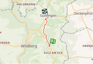
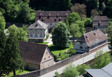
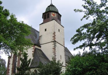
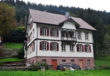
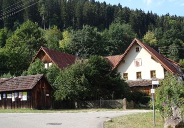
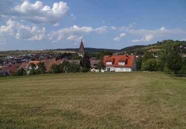
Randonnée A pied de 3,9 km à découvrir à Bade-Wurtemberg, Landkreis Calw, Wildberg. Cette randonnée est proposée par SityTrail - itinéraires balisés pédestres.
Description
Symbole: Gelbe Route auf weißem Grund
Localisation
Pays :
Allemagne
Région :
Bade-Wurtemberg
Département/Province :
Landkreis Calw
Commune :
Wildberg
Localité :
Unknown
Départ:(Dec)
Départ:(UTM)
483476 ; 5385437 (32U) N.
Commentaires
Randonnées à proximité
![Randonnée A pied Herrenberg - Streuobsterlebnisweg Kuppingen - Photo](https://media.geolcdn.com/t/375/260/eb0fd420-8e7f-46cf-8af7-96bf08a0fd2d.jpeg&format=jpg&maxdim=2)
![A pied A pied](https://static1.geolcdn.com/sitytour/trail-icons/100.png)
Streuobsterlebnisweg Kuppingen
A pied
Facile
Herrenberg,
Bade-Wurtemberg,
Landkreis Böblingen,
Allemagne
![](/images/other/stat-length.png)
3,4 km | 4,1 km-effort
56min
![](https://static1.geolcdn.com/siteimages/upload/files/16400158638029165_repeat_loop_refresh_sync_direction_icon.png)
Non
![Randonnée A pied Nagold - Katzendarm - Emmingen - Photo](https://media.geolcdn.com/t/375/260/affc6efc-d8ce-42f8-8015-e60535e17e1b.jpeg&format=jpg&maxdim=2)
![A pied A pied](https://static1.geolcdn.com/sitytour/trail-icons/100.png)
Katzendarm - Emmingen
A pied
Facile
Nagold,
Bade-Wurtemberg,
Landkreis Calw,
Allemagne
![](/images/other/stat-length.png)
3,7 km | 5 km-effort
1h 7min
![](https://static1.geolcdn.com/siteimages/upload/files/16400158638029165_repeat_loop_refresh_sync_direction_icon.png)
Non
![Randonnée A pied Wildberg - AugenBlick-Runde Wildberg - Photo](https://media.geolcdn.com/t/375/260/afb4d309-2e1b-4e0b-83cd-93fd93a7a248.jpeg&format=jpg&maxdim=2)
![A pied A pied](https://static1.geolcdn.com/sitytour/trail-icons/100.png)
AugenBlick-Runde Wildberg
A pied
Facile
Wildberg,
Bade-Wurtemberg,
Landkreis Calw,
Allemagne
![](/images/other/stat-length.png)
7,3 km | 11 km-effort
2h 30min
![](https://static1.geolcdn.com/siteimages/upload/files/16400158638029165_repeat_loop_refresh_sync_direction_icon.png)
Oui
![Randonnée A pied Wildberg - Effringen Hauptstraße - Wildberg Marktstraße - Photo](https://media.geolcdn.com/t/375/260/c6c096db-59a2-44e3-b22f-05748b1c2d4a.jpeg&format=jpg&maxdim=2)
![A pied A pied](https://static1.geolcdn.com/sitytour/trail-icons/100.png)
Effringen Hauptstraße - Wildberg Marktstraße
A pied
Facile
Wildberg,
Bade-Wurtemberg,
Landkreis Calw,
Allemagne
![](/images/other/stat-length.png)
3,9 km | 4,6 km-effort
1h 2min
![](https://static1.geolcdn.com/siteimages/upload/files/16400158638029165_repeat_loop_refresh_sync_direction_icon.png)
Non
![Randonnée A pied Calw - AugenBlick-Runde Calw-Holzbronn - Photo](https://media.geolcdn.com/t/375/260/067a5c3e-4f3c-470d-a947-45644c32a91b.jpeg&format=jpg&maxdim=2)
![A pied A pied](https://static1.geolcdn.com/sitytour/trail-icons/100.png)
AugenBlick-Runde Calw-Holzbronn
A pied
Facile
Calw,
Bade-Wurtemberg,
Landkreis Calw,
Allemagne
![](/images/other/stat-length.png)
7,6 km | 11,4 km-effort
2h 35min
![](https://static1.geolcdn.com/siteimages/upload/files/16400158638029165_repeat_loop_refresh_sync_direction_icon.png)
Non
![Randonnée A pied Neubulach - Gutleutbrücke - Seitzental - Photo](https://media.geolcdn.com/t/375/260/8f24678b-54d1-4464-ba83-a5252375f152.jpeg&format=jpg&maxdim=2)
![A pied A pied](https://static1.geolcdn.com/sitytour/trail-icons/100.png)
Gutleutbrücke - Seitzental
A pied
Facile
Neubulach,
Bade-Wurtemberg,
Landkreis Calw,
Allemagne
![](/images/other/stat-length.png)
3,6 km | 4,4 km-effort
1h 0min
![](https://static1.geolcdn.com/siteimages/upload/files/16400158638029165_repeat_loop_refresh_sync_direction_icon.png)
Non
![Randonnée A pied Wildberg - Sulz am Eck - Gültlinger Kapf - Photo](https://media.geolcdn.com/t/375/260/3ab78c1d-4fc1-4e27-b73d-506371aaa869.jpeg&format=jpg&maxdim=2)
![A pied A pied](https://static1.geolcdn.com/sitytour/trail-icons/100.png)
Sulz am Eck - Gültlinger Kapf
A pied
Facile
Wildberg,
Bade-Wurtemberg,
Landkreis Calw,
Allemagne
![](/images/other/stat-length.png)
4 km | 5,5 km-effort
1h 14min
![](https://static1.geolcdn.com/siteimages/upload/files/16400158638029165_repeat_loop_refresh_sync_direction_icon.png)
Non
![Randonnée A pied Aidlingen - DE-Dachtel Bürgerhaus - Bierkeller - Dachteler Linde - Photo](https://media.geolcdn.com/t/375/260/29cbc548-32dc-423b-bdf4-261fb0206665.jpeg&format=jpg&maxdim=2)
![A pied A pied](https://static1.geolcdn.com/sitytour/trail-icons/100.png)
DE-Dachtel Bürgerhaus - Bierkeller - Dachteler Linde
A pied
Facile
Aidlingen,
Bade-Wurtemberg,
Landkreis Böblingen,
Allemagne
![](/images/other/stat-length.png)
3,8 km | 4,7 km-effort
1h 4min
![](https://static1.geolcdn.com/siteimages/upload/files/16400158638029165_repeat_loop_refresh_sync_direction_icon.png)
Non
![Randonnée A pied Deckenpfronn - Deckenpfronn Rathaus - Schützenhaus - Segelflugplatz - Photo](https://media.geolcdn.com/t/375/260/b1567d41-cae2-4ba0-832b-d04649ca3bdf.jpeg&format=jpg&maxdim=2)
![A pied A pied](https://static1.geolcdn.com/sitytour/trail-icons/100.png)
Deckenpfronn Rathaus - Schützenhaus - Segelflugplatz
A pied
Facile
Deckenpfronn,
Bade-Wurtemberg,
Landkreis Böblingen,
Allemagne
![](/images/other/stat-length.png)
4,9 km | 6,2 km-effort
1h 24min
![](https://static1.geolcdn.com/siteimages/upload/files/16400158638029165_repeat_loop_refresh_sync_direction_icon.png)
Non