Randonnée A pied Nabburg - Wanderroute Kulmweg - Photo

Tous les sentiers balisés d’Europe GUIDE+

© OpenStreetMap contributors
Longueur
Longueur
9,1 km
Altitude max
Altitude max
633 m
Dénivelé positif
Dénivelé positif
90 m
Km-Effort
Km-Effort  
11,1 km
Altitude min
Altitude min
380 m
Dénivelé négatif
Dénivelé négatif
338 m
Boucle
Boucle
Non
Balise
Balise
Date de création :
2022-02-11 14:07:34.986
Dernière modification :
2022-02-11 14:07:34.986

(0 Avis)

A pied
A pied
2h31
Difficulté : Facile

Scannez ce code QR pour ouvrir la randonnée dans l'application SityTrail

Application GPS de randonnée GRATUITE

Logo SityTrail SityTrail

IGN / Instituts géographiques

Télécharger SityTrail sur l'App Store Télécharger SityTrail sur Google Play

Logo SityTrail SityTrail World

Le monde est à vous

Télécharger SityTrail sur l'App Store Télécharger SityTrail sur Google Play Télécharger SityTrail sur Huawei AppGallery

À propos

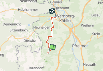
Randonnée A pied de 9,1 km à découvrir à Bavière, Landkreis Schwandorf, Nabburg. Cette randonnée est proposée par SityTrail - itinéraires balisés pédestres.

Description

Randonnée créée par Oberpfälzer Wald-Verein.

Weg führt durch den Markt Wernberg in westlicher Richtung; stetig leicht ansteigend durch Wald und Fluren; Anschlußwege in Richtung Nabburg auf dem Kulmstein. Schlüssel für den Turm in der Gaststätte zum Kulm erhältlich.

Profil altimétrique

Photos

Localisation

Pays :
Allemagne
Région :
Bavière
Département/Province :
Landkreis Schwandorf
Commune :
Nabburg
Localité :
Unknown
Départ:(UTM)
290759 ; 5484996 (33U) N.

Randonnées à proximité

Randonnée A pied Nabburg - Hallerdenkmal - Photo
A pied
GUIDE+

A pied

Facile
Nabburg, Bavière, Landkreis Schwandorf, Allemagne
6,4 km | 8,4 km-effort
1h 54min
Oui
Randonnée A pied Nabburg - Etzelhofer Rangen - Photo
A pied
GUIDE+

A pied

Facile
Nabburg, Bavière, Landkreis Schwandorf, Allemagne
4,9 km | 6,4 km-effort
1h 27min
Non
Randonnée A pied Nabburg - Kulmwanderweg - Photo
A pied
GUIDE+

A pied

Facile
Nabburg, Bavière, Landkreis Schwandorf, Allemagne
6,8 km | 8,4 km-effort
1h 54min
Non
Randonnée A pied Stulln - Reichhartschacht - Photo
A pied
GUIDE+

A pied

Facile
Stulln, Bavière, Landkreis Schwandorf, Allemagne
6 km | 7,6 km-effort
1h 43min
Non
Randonnée A pied Pfreimd - Eixlberg Rundweg 1 - Photo
A pied
GUIDE+

A pied

Facile
Pfreimd, Bavière, Landkreis Schwandorf, Allemagne
4,1 km | 5,5 km-effort
1h 14min
Oui
Randonnée A pied Nabburg - Wanderroute Pfreimd/Sportplatz-Kulm - Photo
A pied
GUIDE+

A pied

Facile
Nabburg, Bavière, Landkreis Schwandorf, Allemagne
5,6 km | 7,3 km-effort
1h 39min
Non


Fermer
Mes abonnements