![](/images/other/stat-length.png)
![Randonnée A pied Schneverdingen - Nordic Walking 40S Niederhaverbeck - Photo](https://media.geolcdn.com/t/1900/400/00bc88a2-46af-4b0c-9a93-9df22247262c.jpeg&format=pjpeg&maxdim=2)
Nordic Walking 40S Niederhaverbeck
SityTrail - itinéraires balisés pédestres
Tous les sentiers balisés d’Europe GUIDE+
![Longueur](/images/other/stat-length.png)
Longueur
16,4 km
![Altitude max](https://static1.geolcdn.com/siteimages/upload/files/1508320355ic_sort_altitude_max_24dp.png)
Altitude max
145 m
![Dénivelé positif](https://static1.geolcdn.com/siteimages/upload/files/1508320355ic_sort_den_pos_24dp.png)
Dénivelé positif
184 m
![Km-Effort](/images/other/stat-length.png)
Km-Effort
18,9 km
![Altitude min](https://static1.geolcdn.com/siteimages/upload/files/1508320355ic_sort_altitude_min_24dp.png)
Altitude min
81 m
![Dénivelé négatif](https://static1.geolcdn.com/siteimages/upload/files/1508320355ic_sort_den_neg_24dp.png)
Dénivelé négatif
185 m
![Boucle](https://static1.geolcdn.com/siteimages/upload/files/16400158638029165_repeat_loop_refresh_sync_direction_icon.png)
Boucle
Oui
Balise
Date de création :
2022-02-11 13:51:38.452
Dernière modification :
2022-02-11 13:51:38.452
![A pied](https://static1.geolcdn.com/sitytour/trail-icons/100.png)
4h17
Difficulté : Facile
![Scannez ce code QR pour ouvrir la randonnée dans l'application SityTrail](https://capi.geolives.com/qq0zvz2zws4bq2lad0pu/sitytour/trails/3091402/qr.png?size=200)
Application GPS de randonnée GRATUITE
À propos
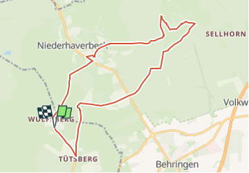
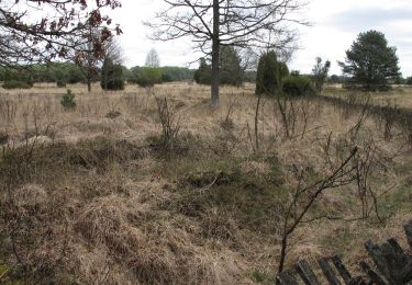
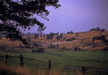
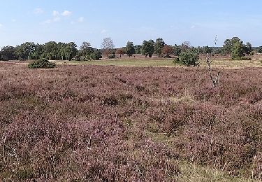
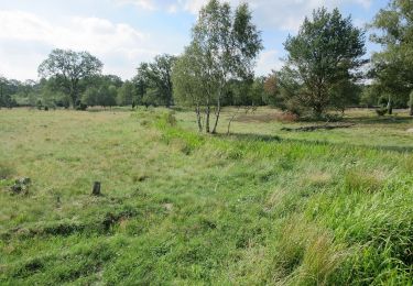
Randonnée A pied de 16,4 km à découvrir à Basse-Saxe, Heide (arrondissement), Schneverdingen. Cette randonnée est proposée par SityTrail - itinéraires balisés pédestres.
Description
Randonnée créée par Verein Naturparkregion Lüneburger Heide e.V..
Site web: https://naturpark-lueneburger-heide.de/
Localisation
Pays :
Allemagne
Région :
Basse-Saxe
Département/Province :
Heide (arrondissement)
Commune :
Schneverdingen
Localité :
Unknown
Départ:(Dec)
Départ:(UTM)
560325 ; 5886352 (32U) N.
Commentaires
Randonnées à proximité
![Randonnée A pied Bispingen - Rundwanderweg Wilsede W2 - Photo](https://media.geolcdn.com/t/375/260/481eae8e-6971-4b86-bf06-c56edfde3a86.jpeg&format=jpg&maxdim=2)
![A pied A pied](https://static1.geolcdn.com/sitytour/trail-icons/100.png)
Rundwanderweg Wilsede W2
A pied
Facile
Bispingen,
Basse-Saxe,
Heide (arrondissement),
Allemagne
![](/images/other/stat-length.png)
3,7 km | 4,2 km-effort
57min
![](https://static1.geolcdn.com/siteimages/upload/files/16400158638029165_repeat_loop_refresh_sync_direction_icon.png)
Oui
![Randonnée A pied Bispingen - Rundwanderweg Wilsede W1 - Photo](https://media.geolcdn.com/t/375/260/091b0282-9b2e-4708-ad04-244efa3a168b.jpeg&format=jpg&maxdim=2)
![A pied A pied](https://static1.geolcdn.com/sitytour/trail-icons/100.png)
Rundwanderweg Wilsede W1
A pied
Facile
Bispingen,
Basse-Saxe,
Heide (arrondissement),
Allemagne
![](/images/other/stat-length.png)
3,4 km | 4,2 km-effort
56min
![](https://static1.geolcdn.com/siteimages/upload/files/16400158638029165_repeat_loop_refresh_sync_direction_icon.png)
Non
![Randonnée A pied Bispingen - Rundwanderweg Behringen B2 - Photo](https://media.geolcdn.com/t/375/260/00bc88a2-46af-4b0c-9a93-9df22247262c.jpeg&format=jpg&maxdim=2)
![A pied A pied](https://static1.geolcdn.com/sitytour/trail-icons/100.png)
Rundwanderweg Behringen B2
A pied
Facile
Bispingen,
Basse-Saxe,
Heide (arrondissement),
Allemagne
![](/images/other/stat-length.png)
7,4 km | 8,3 km-effort
1h 53min
![](https://static1.geolcdn.com/siteimages/upload/files/16400158638029165_repeat_loop_refresh_sync_direction_icon.png)
Non
![Randonnée A pied Bispingen - Rundwanderweg Niederhaverbeck N3 - Photo](https://media.geolcdn.com/t/375/260/1cd2d58f-e216-4ace-86b4-73edb5a21d78.jpeg&format=jpg&maxdim=2)
![A pied A pied](https://static1.geolcdn.com/sitytour/trail-icons/100.png)
Rundwanderweg Niederhaverbeck N3
A pied
Facile
Bispingen,
Basse-Saxe,
Heide (arrondissement),
Allemagne
![](/images/other/stat-length.png)
4,8 km | 5,7 km-effort
1h 18min
![](https://static1.geolcdn.com/siteimages/upload/files/16400158638029165_repeat_loop_refresh_sync_direction_icon.png)
Non
![Randonnée A pied Bispingen - Rundwanderweg Niederhaverbeck N2 - Photo](https://media.geolcdn.com/t/375/260/4cf8be34-63a2-45d8-b800-a3394796df73.jpeg&format=jpg&maxdim=2)
![A pied A pied](https://static1.geolcdn.com/sitytour/trail-icons/100.png)
Rundwanderweg Niederhaverbeck N2
A pied
Facile
Bispingen,
Basse-Saxe,
Heide (arrondissement),
Allemagne
![](/images/other/stat-length.png)
6,3 km | 7,1 km-effort
1h 36min
![](https://static1.geolcdn.com/siteimages/upload/files/16400158638029165_repeat_loop_refresh_sync_direction_icon.png)
Oui
![Randonnée A pied Bispingen - Rundwanderweg Niederhaverbeck N1 - Photo](https://media.geolcdn.com/t/375/260/1cd2d58f-e216-4ace-86b4-73edb5a21d78.jpeg&format=jpg&maxdim=2)
![A pied A pied](https://static1.geolcdn.com/sitytour/trail-icons/100.png)
Rundwanderweg Niederhaverbeck N1
A pied
Facile
Bispingen,
Basse-Saxe,
Heide (arrondissement),
Allemagne
![](/images/other/stat-length.png)
10,3 km | 11,7 km-effort
2h 38min
![](https://static1.geolcdn.com/siteimages/upload/files/16400158638029165_repeat_loop_refresh_sync_direction_icon.png)
Non
![Randonnée A pied Bispingen - Rundwanderweg Oberhaverbeck O3 - Photo](https://media.geolcdn.com/t/375/260/70c22e5b-5329-45ad-8fae-16664e3a2cdb.jpeg&format=jpg&maxdim=2)
![A pied A pied](https://static1.geolcdn.com/sitytour/trail-icons/100.png)
Rundwanderweg Oberhaverbeck O3
A pied
Facile
Bispingen,
Basse-Saxe,
Heide (arrondissement),
Allemagne
![](/images/other/stat-length.png)
7,5 km | 8,7 km-effort
1h 58min
![](https://static1.geolcdn.com/siteimages/upload/files/16400158638029165_repeat_loop_refresh_sync_direction_icon.png)
Non
![Randonnée A pied Bispingen - Rundwanderweg Oberhaverbeck O2 - Photo](https://media.geolcdn.com/t/375/260/70c22e5b-5329-45ad-8fae-16664e3a2cdb.jpeg&format=jpg&maxdim=2)
![A pied A pied](https://static1.geolcdn.com/sitytour/trail-icons/100.png)
Rundwanderweg Oberhaverbeck O2
A pied
Facile
Bispingen,
Basse-Saxe,
Heide (arrondissement),
Allemagne
![](/images/other/stat-length.png)
8,3 km | 9,9 km-effort
2h 15min
![](https://static1.geolcdn.com/siteimages/upload/files/16400158638029165_repeat_loop_refresh_sync_direction_icon.png)
Non
![Randonnée A pied Bispingen - Rundwanderweg Oberhaverbeck O1 - Photo](https://media.geolcdn.com/t/375/260/50ceb4e4-d5ca-4289-bc45-d599f853c5c8.jpeg&format=jpg&maxdim=2)
![A pied A pied](https://static1.geolcdn.com/sitytour/trail-icons/100.png)
Rundwanderweg Oberhaverbeck O1
A pied
Facile
Bispingen,
Basse-Saxe,
Heide (arrondissement),
Allemagne
![](/images/other/stat-length.png)
12 km | 13,5 km-effort
3h 4min
![](https://static1.geolcdn.com/siteimages/upload/files/16400158638029165_repeat_loop_refresh_sync_direction_icon.png)
Oui