![](/images/other/stat-length.png)
![Randonnée A pied Schwarzenfeld - Westernbergweg - Photo](https://media.geolcdn.com/t/1900/400/ext.pjpeg?maxdim=2&url=https%3A%2F%2Fmedia.geolcdn.com%2Ff%2Fe6e4405c-bce9-4b89-94a4-2cffa165e0ce.jpeg)
Westernbergweg
SityTrail - itinéraires balisés pédestres
Tous les sentiers balisés d’Europe PRO
![Longueur](/images/other/stat-length.png)
Longueur
10,9 km
![Altitude max](https://static1.geolcdn.com/siteimages/upload/files/1508320355ic_sort_altitude_max_24dp.png)
Altitude max
444 m
![Dénivelé positif](https://static1.geolcdn.com/siteimages/upload/files/1508320355ic_sort_den_pos_24dp.png)
Dénivelé positif
140 m
![Km-Effort](/images/other/stat-length.png)
Km-Effort
12,8 km
![Altitude min](https://static1.geolcdn.com/siteimages/upload/files/1508320355ic_sort_altitude_min_24dp.png)
Altitude min
361 m
![Dénivelé négatif](https://static1.geolcdn.com/siteimages/upload/files/1508320355ic_sort_den_neg_24dp.png)
Dénivelé négatif
136 m
![Boucle](https://static1.geolcdn.com/siteimages/upload/files/16400158638029165_repeat_loop_refresh_sync_direction_icon.png)
Boucle
Oui
Balise
Date de création :
2022-02-11 13:51:05.842
Dernière modification :
2022-02-11 13:51:05.842
![A pied](https://static1.geolcdn.com/sitytour/trail-icons/100.png)
2h54
Difficulté : Facile
![Scannez ce code QR pour ouvrir la randonnée dans l'application SityTrail](https://capi.geolives.com/qq0zvz2zws4bq2lad0pu/sitytour/trails/3091382/qr.png?size=200)
Application GPS de randonnée GRATUITE
À propos
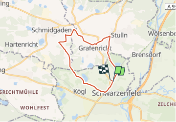
Randonnée A pied de 10,9 km à découvrir à Bavière, Landkreis Schwandorf, Schwarzenfeld. Cette randonnée est proposée par SityTrail - itinéraires balisés pédestres.
Description
Randonnée créée par Markt Schwarzenfeld.
Wanderzeichen teilweise nur in einer Richtung gut sichtbar! complete!
Symbole: Blaue Raute auf weißem Grund
Localisation
Pays :
Allemagne
Région :
Bavière
Département/Province :
Landkreis Schwandorf
Commune :
Schwarzenfeld
Localité :
Unknown
Départ:(Dec)
Départ:(UTM)
292234 ; 5475671 (33U) N.
Commentaires
Randonnées à proximité
![Randonnée A pied Stulln - Reichhartschacht - Photo](https://media.geolcdn.com/t/375/260/ext.jpg?maxdim=2&url=https%3A%2F%2Fmedia.geolcdn.com%2Ff%2F4f006f09-e789-428a-a760-6529a2248b19.jpeg)
![A pied A pied](https://static1.geolcdn.com/sitytour/trail-icons/100.png)
Reichhartschacht
A pied
Facile
Stulln,
Bavière,
Landkreis Schwandorf,
Allemagne
![](/images/other/stat-length.png)
6 km | 7,6 km-effort
1h 43min
![](https://static1.geolcdn.com/siteimages/upload/files/16400158638029165_repeat_loop_refresh_sync_direction_icon.png)
Non
![Randonnée A pied Schwandorf - Baustadl-Lindenlohe-Holzhaus - Photo](https://media.geolcdn.com/t/375/260/ext.jpg?maxdim=2&url=https%3A%2F%2Fmedia.geolcdn.com%2Ff%2Fdddb3b8b-d7f0-48d0-aae4-b286912c1038.jpeg)
![A pied A pied](https://static1.geolcdn.com/sitytour/trail-icons/100.png)
Baustadl-Lindenlohe-Holzhaus
A pied
Facile
Schwandorf,
Bavière,
Landkreis Schwandorf,
Allemagne
![](/images/other/stat-length.png)
8,5 km | 10,1 km-effort
2h 18min
![](https://static1.geolcdn.com/siteimages/upload/files/16400158638029165_repeat_loop_refresh_sync_direction_icon.png)
Non
![Randonnée A pied Nabburg - Darlesberg - Photo](https://media.geolcdn.com/t/375/260/ext.jpg?maxdim=2&url=https%3A%2F%2Fstatic1.geolcdn.com%2Fsiteimages%2Fupload%2Ffiles%2F1545311037marcheuse_200dpi.jpg)
![A pied A pied](https://static1.geolcdn.com/sitytour/trail-icons/100.png)
Darlesberg
A pied
Facile
Nabburg,
Bavière,
Landkreis Schwandorf,
Allemagne
![](/images/other/stat-length.png)
3,7 km | 5 km-effort
1h 7min
![](https://static1.geolcdn.com/siteimages/upload/files/16400158638029165_repeat_loop_refresh_sync_direction_icon.png)
Non
![Randonnée A pied Nabburg - Wolfsberg - Photo](https://media.geolcdn.com/t/375/260/ext.jpg?maxdim=2&url=https%3A%2F%2Fstatic1.geolcdn.com%2Fsiteimages%2Fupload%2Ffiles%2F1545311037marcheuse_200dpi.jpg)
![A pied A pied](https://static1.geolcdn.com/sitytour/trail-icons/100.png)
Wolfsberg
A pied
Facile
Nabburg,
Bavière,
Landkreis Schwandorf,
Allemagne
![](/images/other/stat-length.png)
4,7 km | 6,3 km-effort
1h 25min
![](https://static1.geolcdn.com/siteimages/upload/files/16400158638029165_repeat_loop_refresh_sync_direction_icon.png)
Oui
![Randonnée A pied Nabburg - Zitterbach-Rundweg - Photo](https://media.geolcdn.com/t/375/260/ext.jpg?maxdim=2&url=https%3A%2F%2Fstatic1.geolcdn.com%2Fsiteimages%2Fupload%2Ffiles%2F1545311037marcheuse_200dpi.jpg)
![A pied A pied](https://static1.geolcdn.com/sitytour/trail-icons/100.png)
Zitterbach-Rundweg
A pied
Facile
Nabburg,
Bavière,
Landkreis Schwandorf,
Allemagne
![](/images/other/stat-length.png)
6,1 km | 7,9 km-effort
1h 47min
![](https://static1.geolcdn.com/siteimages/upload/files/16400158638029165_repeat_loop_refresh_sync_direction_icon.png)
Non
![Randonnée A pied Nabburg - Kocherstollen-Rundweg - Photo](https://media.geolcdn.com/t/375/260/ext.jpg?maxdim=2&url=https%3A%2F%2Fstatic1.geolcdn.com%2Fsiteimages%2Fupload%2Ffiles%2F1545311037marcheuse_200dpi.jpg)
![A pied A pied](https://static1.geolcdn.com/sitytour/trail-icons/100.png)
Kocherstollen-Rundweg
A pied
Facile
Nabburg,
Bavière,
Landkreis Schwandorf,
Allemagne
![](/images/other/stat-length.png)
6,6 km | 8,5 km-effort
1h 55min
![](https://static1.geolcdn.com/siteimages/upload/files/16400158638029165_repeat_loop_refresh_sync_direction_icon.png)
Oui