![](/images/other/stat-length.png)
![Randonnée A pied Detmold - Rundwanderweg A2 [Diestelbruch] - Photo](https://media.geolcdn.com/t/1900/400/ext.pjpeg?maxdim=2&url=https%3A%2F%2Fmedia.geolcdn.com%2Ff%2Faaf5bfea-b5f0-4eb2-baf2-316d21f2e560.jpeg)
Rundwanderweg A2 [Diestelbruch]
SityTrail - itinéraires balisés pédestres
Tous les sentiers balisés d’Europe PRO
![Longueur](/images/other/stat-length.png)
Longueur
3,1 km
![Altitude max](https://static1.geolcdn.com/siteimages/upload/files/1508320355ic_sort_altitude_max_24dp.png)
Altitude max
262 m
![Dénivelé positif](https://static1.geolcdn.com/siteimages/upload/files/1508320355ic_sort_den_pos_24dp.png)
Dénivelé positif
53 m
![Km-Effort](/images/other/stat-length.png)
Km-Effort
3,9 km
![Altitude min](https://static1.geolcdn.com/siteimages/upload/files/1508320355ic_sort_altitude_min_24dp.png)
Altitude min
202 m
![Dénivelé négatif](https://static1.geolcdn.com/siteimages/upload/files/1508320355ic_sort_den_neg_24dp.png)
Dénivelé négatif
57 m
![Boucle](https://static1.geolcdn.com/siteimages/upload/files/16400158638029165_repeat_loop_refresh_sync_direction_icon.png)
Boucle
Oui
Balise
Date de création :
2022-02-11 13:48:56.239
Dernière modification :
2022-02-11 13:48:56.239
![A pied](https://static1.geolcdn.com/sitytour/trail-icons/100.png)
52m
Difficulté : Facile
![Scannez ce code QR pour ouvrir la randonnée dans l'application SityTrail](https://capi.geolives.com/qq0zvz2zws4bq2lad0pu/sitytour/trails/3091281/qr.png?size=200)
Application GPS de randonnée GRATUITE
À propos
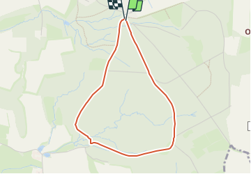
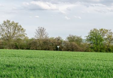
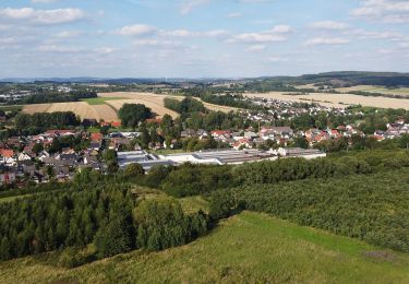
Randonnée A pied de 3,1 km à découvrir à Rhénanie-du-Nord-Westphalie, Kreis Lippe, Detmold. Cette randonnée est proposée par SityTrail - itinéraires balisés pédestres.
Description
Randonnée créée par Teutoburger-Wald-Verein e.V..
Localisation
Pays :
Allemagne
Région :
Rhénanie-du-Nord-Westphalie
Département/Province :
Kreis Lippe
Commune :
Detmold
Localité :
Unknown
Départ:(Dec)
Départ:(UTM)
496637 ; 5752889 (32U) N.
Commentaires
Randonnées à proximité
![Randonnée A pied Horn-Bad Meinberg - Zugangsweg Hermannshöhen - Horn-Bad Meinberg - Photo](https://media.geolcdn.com/t/375/260/ext.jpg?maxdim=2&url=https%3A%2F%2Fmedia.geolcdn.com%2Ff%2F481dc017-712c-4a92-87e6-77c38ebad9f4.jpeg)
![A pied A pied](https://static1.geolcdn.com/sitytour/trail-icons/100.png)
Zugangsweg Hermannshöhen - Horn-Bad Meinberg
A pied
Facile
Horn-Bad Meinberg,
Rhénanie-du-Nord-Westphalie,
Kreis Lippe,
Allemagne
![](/images/other/stat-length.png)
5,5 km | 6,2 km-effort
1h 25min
![](https://static1.geolcdn.com/siteimages/upload/files/16400158638029165_repeat_loop_refresh_sync_direction_icon.png)
Non
![Randonnée A pied Horn-Bad Meinberg - Terrainkurweg 9 [Bad Meinberg] - Photo](https://media.geolcdn.com/t/375/260/ext.jpg?maxdim=2&url=https%3A%2F%2Fmedia.geolcdn.com%2Ff%2F415dab2e-d838-41c3-b2c1-c698395be57c.jpeg)
![A pied A pied](https://static1.geolcdn.com/sitytour/trail-icons/100.png)
Terrainkurweg 9 [Bad Meinberg]
A pied
Facile
Horn-Bad Meinberg,
Rhénanie-du-Nord-Westphalie,
Kreis Lippe,
Allemagne
![](/images/other/stat-length.png)
5,5 km | 7,1 km-effort
1h 36min
![](https://static1.geolcdn.com/siteimages/upload/files/16400158638029165_repeat_loop_refresh_sync_direction_icon.png)
Oui
![Randonnée A pied Horn-Bad Meinberg - Terrainkurweg 5 [Bad Meinberg] - Photo](https://media.geolcdn.com/t/375/260/ext.jpg?maxdim=2&url=https%3A%2F%2Fmedia.geolcdn.com%2Ff%2Fc6c364b8-a98c-4894-be50-01092c15d2a2.jpeg)
![A pied A pied](https://static1.geolcdn.com/sitytour/trail-icons/100.png)
Terrainkurweg 5 [Bad Meinberg]
A pied
Facile
Horn-Bad Meinberg,
Rhénanie-du-Nord-Westphalie,
Kreis Lippe,
Allemagne
![](/images/other/stat-length.png)
3,3 km | 3,9 km-effort
53min
![](https://static1.geolcdn.com/siteimages/upload/files/16400158638029165_repeat_loop_refresh_sync_direction_icon.png)
Oui
![Randonnée A pied Horn-Bad Meinberg - Terrainkurweg 4 [Bad Meinberg] - Photo](https://media.geolcdn.com/t/375/260/ext.jpg?maxdim=2&url=https%3A%2F%2Fmedia.geolcdn.com%2Ff%2F17855ced-c021-469c-b31b-b1f4ceaf95e0.jpeg)
![A pied A pied](https://static1.geolcdn.com/sitytour/trail-icons/100.png)
Terrainkurweg 4 [Bad Meinberg]
A pied
Facile
Horn-Bad Meinberg,
Rhénanie-du-Nord-Westphalie,
Kreis Lippe,
Allemagne
![](/images/other/stat-length.png)
5,2 km | 6,3 km-effort
1h 26min
![](https://static1.geolcdn.com/siteimages/upload/files/16400158638029165_repeat_loop_refresh_sync_direction_icon.png)
Oui
![Randonnée A pied Horn-Bad Meinberg - Ruhe - Wanderweg Norderteich [Bad Meinberg] (VitalWanderWelt) - Photo](https://media.geolcdn.com/t/375/260/ext.jpg?maxdim=2&url=https%3A%2F%2Fmedia.geolcdn.com%2Ff%2F62948217-785e-4bf8-a3a7-9c99707dba50.jpeg)
![A pied A pied](https://static1.geolcdn.com/sitytour/trail-icons/100.png)
Ruhe - Wanderweg Norderteich [Bad Meinberg] (VitalWanderWelt)
A pied
Facile
Horn-Bad Meinberg,
Rhénanie-du-Nord-Westphalie,
Kreis Lippe,
Allemagne
![](/images/other/stat-length.png)
5 km | 6 km-effort
1h 22min
![](https://static1.geolcdn.com/siteimages/upload/files/16400158638029165_repeat_loop_refresh_sync_direction_icon.png)
Non
![Randonnée A pied Horn-Bad Meinberg - DSV nordic aktiv - rote Route [Bad Meinberg] (Nordic Walking) - Photo](https://media.geolcdn.com/t/375/260/ext.jpg?maxdim=2&url=https%3A%2F%2Fmedia.geolcdn.com%2Ff%2F415dab2e-d838-41c3-b2c1-c698395be57c.jpeg)
![A pied A pied](https://static1.geolcdn.com/sitytour/trail-icons/100.png)
DSV nordic aktiv - rote Route [Bad Meinberg] (Nordic Walking)
A pied
Facile
Horn-Bad Meinberg,
Rhénanie-du-Nord-Westphalie,
Kreis Lippe,
Allemagne
![](/images/other/stat-length.png)
3,6 km | 4,8 km-effort
1h 5min
![](https://static1.geolcdn.com/siteimages/upload/files/16400158638029165_repeat_loop_refresh_sync_direction_icon.png)
Non
![Randonnée A pied Detmold - DSV nordic aktiv - schwarze Route [Bad Meinberg] (Nordic Walking) - Photo](https://media.geolcdn.com/t/375/260/ext.jpg?maxdim=2&url=https%3A%2F%2Fmedia.geolcdn.com%2Ff%2Faaf5bfea-b5f0-4eb2-baf2-316d21f2e560.jpeg)
![A pied A pied](https://static1.geolcdn.com/sitytour/trail-icons/100.png)
DSV nordic aktiv - schwarze Route [Bad Meinberg] (Nordic Walking)
A pied
Facile
Detmold,
Rhénanie-du-Nord-Westphalie,
Kreis Lippe,
Allemagne
![](/images/other/stat-length.png)
3,2 km | 4 km-effort
54min
![](https://static1.geolcdn.com/siteimages/upload/files/16400158638029165_repeat_loop_refresh_sync_direction_icon.png)
Non
![Randonnée A pied Detmold - Gustav-Mesch-Weg - Photo](https://media.geolcdn.com/t/375/260/ext.jpg?maxdim=2&url=https%3A%2F%2Fmedia.geolcdn.com%2Ff%2F6a014bdc-4952-4e2f-91b3-750027407d9f.jpeg)
![A pied A pied](https://static1.geolcdn.com/sitytour/trail-icons/100.png)
Gustav-Mesch-Weg
A pied
Facile
Detmold,
Rhénanie-du-Nord-Westphalie,
Kreis Lippe,
Allemagne
![](/images/other/stat-length.png)
7,6 km | 9,7 km-effort
2h 12min
![](https://static1.geolcdn.com/siteimages/upload/files/16400158638029165_repeat_loop_refresh_sync_direction_icon.png)
Non
![Randonnée A pied Detmold - Rundwanderweg A1 [Diestelbruch] - Photo](https://media.geolcdn.com/t/375/260/ext.jpg?maxdim=2&url=https%3A%2F%2Fmedia.geolcdn.com%2Ff%2Faaf5bfea-b5f0-4eb2-baf2-316d21f2e560.jpeg)
![A pied A pied](https://static1.geolcdn.com/sitytour/trail-icons/100.png)
Rundwanderweg A1 [Diestelbruch]
A pied
Facile
Detmold,
Rhénanie-du-Nord-Westphalie,
Kreis Lippe,
Allemagne
![](/images/other/stat-length.png)
3,3 km | 4,1 km-effort
56min
![](https://static1.geolcdn.com/siteimages/upload/files/16400158638029165_repeat_loop_refresh_sync_direction_icon.png)
Oui