Randonnée A pied Schwandorf - Rundweg 2 - Photo

Tous les sentiers balisés d’Europe PRO

© OpenStreetMap contributors
Longueur
Longueur
5,6 km
Altitude max
Altitude max
452 m
Dénivelé positif
Dénivelé positif
113 m
Km-Effort
Km-Effort  
7,1 km
Altitude min
Altitude min
350 m
Dénivelé négatif
Dénivelé négatif
112 m
Boucle
Boucle
Non
Balise
Balise
Date de création :
2022-02-11 13:42:03.288
Dernière modification :
2022-02-11 13:42:03.288

(0 Avis)

A pied
A pied
1h37
Difficulté : Facile

Scannez ce code QR pour ouvrir la randonnée dans l'application SityTrail

Application GPS de randonnée GRATUITE

Logo SityTrail SityTrail

IGN / Instituts géographiques

Télécharger SityTrail sur l'App Store Télécharger SityTrail sur Google Play

Logo SityTrail SityTrail World

Le monde est à vous

Télécharger SityTrail sur l'App Store Télécharger SityTrail sur Google Play Télécharger SityTrail sur Huawei AppGallery

À propos

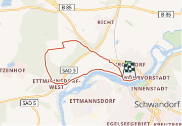
Randonnée A pied de 5,6 km à découvrir à Bavière, Landkreis Schwandorf, Schwandorf. Cette randonnée est proposée par SityTrail - itinéraires balisés pédestres.

Description

Randonnée créée par Oberpfälzer Waldverein Schwandorf.

richtiges Wanderzeichen im Gelände - auf Karte leider nicht darstellbar

Symbole: weißer Kreis mit der 2 in schwarz geschrieben


Site web: http://www.owv-sad.de/index.php?section=ztyp1&id=55&mid=6

Photos

Localisation

Pays :
Allemagne
Région :
Bavière
Département/Province :
Landkreis Schwandorf
Commune :
Schwandorf
Localité :
Unknown
Départ:(UTM)
289139 ; 5468440 (33U) N.

Randonnées à proximité

Randonnée A pied Schwandorf - Wanderweg Rundweg 1
A pied
PRO

A pied

Facile
Schwandorf, Bavière, Landkreis Schwandorf, Allemagne
6 km | 6,6 km-effort
1h 29min
Oui
Randonnée A pied Schwandorf - Rundweg 3
A pied
PRO

A pied

Facile
Schwandorf, Bavière, Landkreis Schwandorf, Allemagne
10,8 km | 13,3 km-effort
3h 2min
Oui


Fermer
Mes abonnements