![](/images/other/stat-length.png)
![Randonnée A pied Markdorf - Wanderwege Markdorf: Hasenweg - Photo](https://media.geolcdn.com/t/1900/400/ext.pjpeg?maxdim=2&url=https%3A%2F%2Fmedia.geolcdn.com%2Ff%2F8ac18547-bf20-4a6b-880d-3d5127ac3f5f.jpeg)
Wanderwege Markdorf: Hasenweg
SityTrail - itinéraires balisés pédestres
Tous les sentiers balisés d’Europe PRO
![Longueur](/images/other/stat-length.png)
Longueur
9,1 km
![Altitude max](https://static1.geolcdn.com/siteimages/upload/files/1508320355ic_sort_altitude_max_24dp.png)
Altitude max
439 m
![Dénivelé positif](https://static1.geolcdn.com/siteimages/upload/files/1508320355ic_sort_den_pos_24dp.png)
Dénivelé positif
75 m
![Km-Effort](/images/other/stat-length.png)
Km-Effort
10,1 km
![Altitude min](https://static1.geolcdn.com/siteimages/upload/files/1508320355ic_sort_altitude_min_24dp.png)
Altitude min
416 m
![Dénivelé négatif](https://static1.geolcdn.com/siteimages/upload/files/1508320355ic_sort_den_neg_24dp.png)
Dénivelé négatif
74 m
![Boucle](https://static1.geolcdn.com/siteimages/upload/files/16400158638029165_repeat_loop_refresh_sync_direction_icon.png)
Boucle
Oui
Balise
Date de création :
2022-02-11 13:40:04.343
Dernière modification :
2022-02-11 13:40:04.343
![A pied](https://static1.geolcdn.com/sitytour/trail-icons/100.png)
2h17
Difficulté : Facile
![Scannez ce code QR pour ouvrir la randonnée dans l'application SityTrail](https://capi.geolives.com/qq0zvz2zws4bq2lad0pu/sitytour/trails/3090852/qr.png?size=200)
Application GPS de randonnée GRATUITE
À propos
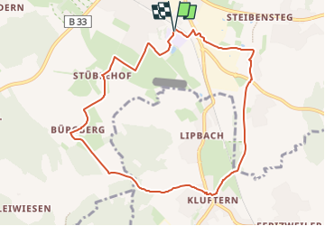
Randonnée A pied de 9,1 km à découvrir à Bade-Wurtemberg, Bodenseekreis, Markdorf. Cette randonnée est proposée par SityTrail - itinéraires balisés pédestres.
Description
Randonnée créée par Tourismusgemeinschaft Gehrenberg-Bodensee.
Symbole: schwarzer Hase auf weißem Grund
Site web: https://www.gehrenberg-bodensee.de/
Localisation
Pays :
Allemagne
Région :
Bade-Wurtemberg
Département/Province :
Bodenseekreis
Commune :
Markdorf
Localité :
Unknown
Départ:(Dec)
Départ:(UTM)
529532 ; 5284584 (32T) N.
Commentaires
Randonnées à proximité
![Randonnée A pied Friedrichshafen - Planetenweg Kluftern - Photo](https://media.geolcdn.com/t/375/260/ext.jpg?maxdim=2&url=https%3A%2F%2Fmedia.geolcdn.com%2Ff%2F46733009-a77d-469a-8bf1-fb80e19f2d17.jpeg)
![A pied A pied](https://static1.geolcdn.com/sitytour/trail-icons/100.png)
Planetenweg Kluftern
A pied
Facile
Friedrichshafen,
Bade-Wurtemberg,
Bodenseekreis,
Allemagne
![](/images/other/stat-length.png)
5,5 km | 6,5 km-effort
1h 28min
![](https://static1.geolcdn.com/siteimages/upload/files/16400158638029165_repeat_loop_refresh_sync_direction_icon.png)
Oui
![Randonnée A pied Bermatingen - Rundweg B5 - Photo](https://media.geolcdn.com/t/375/260/ext.jpg?maxdim=2&url=https%3A%2F%2Fmedia.geolcdn.com%2Ff%2F5fa6ab2f-fb20-4449-9ac8-ef50196935f6.jpeg)
![A pied A pied](https://static1.geolcdn.com/sitytour/trail-icons/100.png)
Rundweg B5
A pied
Facile
Bermatingen,
Bade-Wurtemberg,
Bodenseekreis,
Allemagne
![](/images/other/stat-length.png)
12,3 km | 15,6 km-effort
3h 32min
![](https://static1.geolcdn.com/siteimages/upload/files/16400158638029165_repeat_loop_refresh_sync_direction_icon.png)
Oui
![Randonnée A pied Bermatingen - Rundweg B4 - Photo](https://media.geolcdn.com/t/375/260/ext.jpg?maxdim=2&url=https%3A%2F%2Fmedia.geolcdn.com%2Ff%2Fab7b3cca-1476-48a6-afce-358eba7428e2.jpeg)
![A pied A pied](https://static1.geolcdn.com/sitytour/trail-icons/100.png)
Rundweg B4
A pied
Facile
Bermatingen,
Bade-Wurtemberg,
Bodenseekreis,
Allemagne
![](/images/other/stat-length.png)
7,2 km | 9,5 km-effort
2h 8min
![](https://static1.geolcdn.com/siteimages/upload/files/16400158638029165_repeat_loop_refresh_sync_direction_icon.png)
Oui
![Randonnée A pied Bermatingen - Rundweg B3 - Photo](https://media.geolcdn.com/t/375/260/ext.jpg?maxdim=2&url=https%3A%2F%2Fmedia.geolcdn.com%2Ff%2Fba1a7fea-e706-4424-b12c-59b17b649f8e.jpeg)
![A pied A pied](https://static1.geolcdn.com/sitytour/trail-icons/100.png)
Rundweg B3
A pied
Facile
Bermatingen,
Bade-Wurtemberg,
Bodenseekreis,
Allemagne
![](/images/other/stat-length.png)
4,2 km | 5,5 km-effort
1h 14min
![](https://static1.geolcdn.com/siteimages/upload/files/16400158638029165_repeat_loop_refresh_sync_direction_icon.png)
Oui
![Randonnée A pied Bermatingen - Rundweg B2 - Photo](https://media.geolcdn.com/t/375/260/ext.jpg?maxdim=2&url=https%3A%2F%2Fmedia.geolcdn.com%2Ff%2Fcd072049-360e-431c-bd2c-80671c66591d.jpeg)
![A pied A pied](https://static1.geolcdn.com/sitytour/trail-icons/100.png)
Rundweg B2
A pied
Facile
Bermatingen,
Bade-Wurtemberg,
Bodenseekreis,
Allemagne
![](/images/other/stat-length.png)
6,9 km | 8,1 km-effort
1h 50min
![](https://static1.geolcdn.com/siteimages/upload/files/16400158638029165_repeat_loop_refresh_sync_direction_icon.png)
Oui
![Randonnée A pied Bermatingen - Rundweg B1 - Photo](https://media.geolcdn.com/t/375/260/ext.jpg?maxdim=2&url=https%3A%2F%2Fmedia.geolcdn.com%2Ff%2Fcd072049-360e-431c-bd2c-80671c66591d.jpeg)
![A pied A pied](https://static1.geolcdn.com/sitytour/trail-icons/100.png)
Rundweg B1
A pied
Facile
Bermatingen,
Bade-Wurtemberg,
Bodenseekreis,
Allemagne
![](/images/other/stat-length.png)
3,3 km | 3,7 km-effort
50min
![](https://static1.geolcdn.com/siteimages/upload/files/16400158638029165_repeat_loop_refresh_sync_direction_icon.png)
Oui
![Randonnée A pied Markdorf - Wanderwege Markdorf: Froschweg - Photo](https://media.geolcdn.com/t/375/260/ext.jpg?maxdim=2&url=https%3A%2F%2Fmedia.geolcdn.com%2Ff%2F925776c0-f370-41fd-bf89-cf33cc203a47.jpeg)
![A pied A pied](https://static1.geolcdn.com/sitytour/trail-icons/100.png)
Wanderwege Markdorf: Froschweg
A pied
Facile
Markdorf,
Bade-Wurtemberg,
Bodenseekreis,
Allemagne
![](/images/other/stat-length.png)
4,9 km | 6 km-effort
1h 22min
![](https://static1.geolcdn.com/siteimages/upload/files/16400158638029165_repeat_loop_refresh_sync_direction_icon.png)
Non
![Randonnée A pied Friedrichshafen - Ortsrundweg Kluftern - Südrunde - Photo](https://media.geolcdn.com/t/375/260/ext.jpg?maxdim=2&url=https%3A%2F%2Fmedia.geolcdn.com%2Ff%2F24eac72b-5d33-4d11-abeb-8e8d2d4a2164.jpeg)
![A pied A pied](https://static1.geolcdn.com/sitytour/trail-icons/100.png)
Ortsrundweg Kluftern - Südrunde
A pied
Facile
Friedrichshafen,
Bade-Wurtemberg,
Bodenseekreis,
Allemagne
![](/images/other/stat-length.png)
7,1 km | 8,6 km-effort
1h 57min
![](https://static1.geolcdn.com/siteimages/upload/files/16400158638029165_repeat_loop_refresh_sync_direction_icon.png)
Oui
![Randonnée A pied Immenstaad am Bodensee - Apfel- und Weinspazierweg Immenstaad - Photo](https://media.geolcdn.com/t/375/260/ext.jpg?maxdim=2&url=https%3A%2F%2Fmedia.geolcdn.com%2Ff%2Fb33bc6f1-1882-4bf6-8253-2fc20d7975df.jpeg)
![A pied A pied](https://static1.geolcdn.com/sitytour/trail-icons/100.png)
Apfel- und Weinspazierweg Immenstaad
A pied
Facile
Immenstaad am Bodensee,
Bade-Wurtemberg,
Bodenseekreis,
Allemagne
![](/images/other/stat-length.png)
7,5 km | 8,8 km-effort
2h 0min
![](https://static1.geolcdn.com/siteimages/upload/files/16400158638029165_repeat_loop_refresh_sync_direction_icon.png)
Oui