![](/images/other/stat-length.png)
![Randonnée A pied Gladbeck - Winkel Gelsenkirchen - Bottrop - Photo](https://media.geolcdn.com/t/1900/400/89d2f9dc-da91-4e8b-8ba6-d79a6e7c7184.jpeg&format=pjpeg&maxdim=2)
Winkel Gelsenkirchen - Bottrop
SityTrail - itinéraires balisés pédestres
Tous les sentiers balisés d’Europe GUIDE+
![Longueur](/images/other/stat-length.png)
Longueur
16,9 km
![Altitude max](https://static1.geolcdn.com/siteimages/upload/files/1508320355ic_sort_altitude_max_24dp.png)
Altitude max
81 m
![Dénivelé positif](https://static1.geolcdn.com/siteimages/upload/files/1508320355ic_sort_den_pos_24dp.png)
Dénivelé positif
145 m
![Km-Effort](/images/other/stat-length.png)
Km-Effort
18,9 km
![Altitude min](https://static1.geolcdn.com/siteimages/upload/files/1508320355ic_sort_altitude_min_24dp.png)
Altitude min
29 m
![Dénivelé négatif](https://static1.geolcdn.com/siteimages/upload/files/1508320355ic_sort_den_neg_24dp.png)
Dénivelé négatif
160 m
![Boucle](https://static1.geolcdn.com/siteimages/upload/files/16400158638029165_repeat_loop_refresh_sync_direction_icon.png)
Boucle
Non
Balise
Date de création :
2022-02-11 13:38:32.115
Dernière modification :
2022-02-11 13:38:32.115
![A pied](https://static1.geolcdn.com/sitytour/trail-icons/100.png)
4h17
Difficulté : Facile
![Scannez ce code QR pour ouvrir la randonnée dans l'application SityTrail](https://capi.geolives.com/qq0zvz2zws4bq2lad0pu/sitytour/trails/3090776/qr.png?size=200)
Application GPS de randonnée GRATUITE
À propos
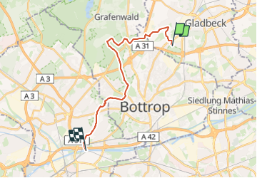
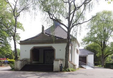
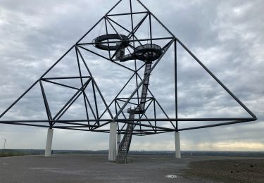
Randonnée A pied de 16,9 km à découvrir à Rhénanie-du-Nord-Westphalie, Kreis Recklinghausen, Gladbeck. Cette randonnée est proposée par SityTrail - itinéraires balisés pédestres.
Description
nur entgegen dem Uhrzeigersinn markiert
Symbole: offener weißer Pfeil, Spitze immer in Wegrichtung
Localisation
Pays :
Allemagne
Région :
Rhénanie-du-Nord-Westphalie
Département/Province :
Kreis Recklinghausen
Commune :
Gladbeck
Localité :
Unknown
Départ:(Dec)
Départ:(UTM)
358290 ; 5713885 (32U) N.
Commentaires
Randonnées à proximité
![Randonnée A pied - Pilgerweg Ge-E - Photo](https://media.geolcdn.com/t/375/260/964f710c-572a-48b5-9b14-16e7266e05cc.jpeg&format=jpg&maxdim=2)
![A pied A pied](https://static1.geolcdn.com/sitytour/trail-icons/100.png)
Pilgerweg Ge-E
A pied
Facile
,
Rhénanie-du-Nord-Westphalie,
Bottrop,
Allemagne
![](/images/other/stat-length.png)
16,1 km | 18,1 km-effort
4h 6min
![](https://static1.geolcdn.com/siteimages/upload/files/16400158638029165_repeat_loop_refresh_sync_direction_icon.png)
Non
![Randonnée A pied - Naturfreundeweg Bottrop - Ruhrtalhaus - Photo](https://media.geolcdn.com/t/375/260/5727e49d-e0dc-4477-aa0f-237428f2ed66.jpeg&format=jpg&maxdim=2)
![A pied A pied](https://static1.geolcdn.com/sitytour/trail-icons/100.png)
Naturfreundeweg Bottrop - Ruhrtalhaus
A pied
Facile
,
Rhénanie-du-Nord-Westphalie,
Bottrop,
Allemagne
![](/images/other/stat-length.png)
7,6 km | 8,6 km-effort
1h 57min
![](https://static1.geolcdn.com/siteimages/upload/files/16400158638029165_repeat_loop_refresh_sync_direction_icon.png)
Non
![Randonnée A pied Gladbeck - Gladbeck Rundweg A4 - Photo](https://media.geolcdn.com/t/375/260/332ae219-17a1-4c7a-8e65-f81021426826.jpeg&format=jpg&maxdim=2)
![A pied A pied](https://static1.geolcdn.com/sitytour/trail-icons/100.png)
Gladbeck Rundweg A4
A pied
Facile
Gladbeck,
Rhénanie-du-Nord-Westphalie,
Kreis Recklinghausen,
Allemagne
![](/images/other/stat-length.png)
3,8 km | 4,1 km-effort
56min
![](https://static1.geolcdn.com/siteimages/upload/files/16400158638029165_repeat_loop_refresh_sync_direction_icon.png)
Non
![Randonnée A pied Gladbeck - Gladbeck Rundweg A5 - Photo](https://media.geolcdn.com/t/375/260/0bde138a-bd3c-407d-a761-bfff1acf4d2a.jpeg&format=jpg&maxdim=2)
![A pied A pied](https://static1.geolcdn.com/sitytour/trail-icons/100.png)
Gladbeck Rundweg A5
A pied
Facile
Gladbeck,
Rhénanie-du-Nord-Westphalie,
Kreis Recklinghausen,
Allemagne
![](/images/other/stat-length.png)
5,1 km | 5,8 km-effort
1h 19min
![](https://static1.geolcdn.com/siteimages/upload/files/16400158638029165_repeat_loop_refresh_sync_direction_icon.png)
Non
![Randonnée A pied Gladbeck - Butendorf Rundweg A3 - Photo](https://media.geolcdn.com/t/375/260/15640434-d48d-4ebe-858e-730c165bd5dd.jpeg&format=jpg&maxdim=2)
![A pied A pied](https://static1.geolcdn.com/sitytour/trail-icons/100.png)
Butendorf Rundweg A3
A pied
Facile
Gladbeck,
Rhénanie-du-Nord-Westphalie,
Kreis Recklinghausen,
Allemagne
![](/images/other/stat-length.png)
10,6 km | 11,7 km-effort
2h 40min
![](https://static1.geolcdn.com/siteimages/upload/files/16400158638029165_repeat_loop_refresh_sync_direction_icon.png)
Oui
![Randonnée A pied - Bottroper Stadtwald Rundweg A1 - Photo](https://media.geolcdn.com/t/375/260/cfc71952-27fa-416e-9f7e-06807d81683a.jpeg&format=jpg&maxdim=2)
![A pied A pied](https://static1.geolcdn.com/sitytour/trail-icons/100.png)
Bottroper Stadtwald Rundweg A1
A pied
Facile
,
Rhénanie-du-Nord-Westphalie,
Bottrop,
Allemagne
![](/images/other/stat-length.png)
4 km | 4,7 km-effort
1h 3min
![](https://static1.geolcdn.com/siteimages/upload/files/16400158638029165_repeat_loop_refresh_sync_direction_icon.png)
Oui
![Randonnée Marche - Tétraédrique - Photo](https://media.geolcdn.com/t/375/260/d94e0594-e2f7-4921-a98c-e59227147aba.jpg&format=jpg&maxdim=2)
![Marche Marche](https://static1.geolcdn.com/sitytour/trail-icons/101.png)
Tétraédrique
Marche
Facile
,
Rhénanie-du-Nord-Westphalie,
Bottrop,
Allemagne
![](/images/other/stat-length.png)
3,2 km | 4,2 km-effort
1h 16min
![](https://static1.geolcdn.com/siteimages/upload/files/16400158638029165_repeat_loop_refresh_sync_direction_icon.png)
Oui