![](/images/other/stat-length.png)
![Randonnée A pied Arnsberg - Hüstener Freiheitsweg - Photo](https://media.geolcdn.com/t/1900/400/ext.pjpeg?maxdim=2&url=https%3A%2F%2Fmedia.geolcdn.com%2Ff%2Faf31ca38-bbae-4784-aa24-a2b97f8cf049.jpeg)
Hüstener Freiheitsweg
SityTrail - itinéraires balisés pédestres
Tous les sentiers balisés d’Europe PRO
![Longueur](/images/other/stat-length.png)
Longueur
17,1 km
![Altitude max](https://static1.geolcdn.com/siteimages/upload/files/1508320355ic_sort_altitude_max_24dp.png)
Altitude max
287 m
![Dénivelé positif](https://static1.geolcdn.com/siteimages/upload/files/1508320355ic_sort_den_pos_24dp.png)
Dénivelé positif
346 m
![Km-Effort](/images/other/stat-length.png)
Km-Effort
22 km
![Altitude min](https://static1.geolcdn.com/siteimages/upload/files/1508320355ic_sort_altitude_min_24dp.png)
Altitude min
155 m
![Dénivelé négatif](https://static1.geolcdn.com/siteimages/upload/files/1508320355ic_sort_den_neg_24dp.png)
Dénivelé négatif
346 m
![Boucle](https://static1.geolcdn.com/siteimages/upload/files/16400158638029165_repeat_loop_refresh_sync_direction_icon.png)
Boucle
Oui
Balise
Date de création :
2022-02-11 13:34:38.126
Dernière modification :
2022-02-11 13:34:38.126
![A pied](https://static1.geolcdn.com/sitytour/trail-icons/100.png)
4h55
Difficulté : Moyen
![Scannez ce code QR pour ouvrir la randonnée dans l'application SityTrail](https://capi.geolives.com/qq0zvz2zws4bq2lad0pu/sitytour/trails/3090605/qr.png?size=200)
Application GPS de randonnée GRATUITE
À propos
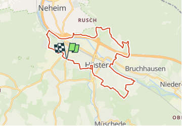
Randonnée A pied de 17,1 km à découvrir à Rhénanie-du-Nord-Westphalie, Hochsauerlandkreis, Arnsberg. Cette randonnée est proposée par SityTrail - itinéraires balisés pédestres.
Description
Randonnée créée par Sauerländischer Gebirgsverein (SGV).
Symbole: Weißes H in weißem Kreis auf schwarzem Grund
Localisation
Pays :
Allemagne
Région :
Rhénanie-du-Nord-Westphalie
Département/Province :
Hochsauerlandkreis
Commune :
Arnsberg
Localité :
Unknown
Départ:(Dec)
Départ:(UTM)
428448 ; 5698266 (32U) N.
Commentaires
Randonnées à proximité
![Randonnée A pied Ense - Fürstenberg-Rundweg bei Neheim Dreieck - Photo](https://media.geolcdn.com/t/375/260/ext.jpg?maxdim=2&url=https%3A%2F%2Fmedia.geolcdn.com%2Ff%2Fbd944918-932e-4fb7-82e7-beb10887c35d.jpeg)
![A pied A pied](https://static1.geolcdn.com/sitytour/trail-icons/100.png)
Fürstenberg-Rundweg bei Neheim Dreieck
A pied
Facile
Ense,
Rhénanie-du-Nord-Westphalie,
Kreis Soest,
Allemagne
![](/images/other/stat-length.png)
4,8 km | 7 km-effort
1h 34min
![](https://static1.geolcdn.com/siteimages/upload/files/16400158638029165_repeat_loop_refresh_sync_direction_icon.png)
Non
![Randonnée A pied Arnsberg - Balken Talsperrenweg - Photo](https://media.geolcdn.com/t/375/260/ext.jpg?maxdim=2&url=https%3A%2F%2Fmedia.geolcdn.com%2Ff%2Fe08b6576-17ff-42a2-87a0-0e8d5ea814d3.jpeg)
![A pied A pied](https://static1.geolcdn.com/sitytour/trail-icons/100.png)
Balken Talsperrenweg
A pied
Facile
Arnsberg,
Rhénanie-du-Nord-Westphalie,
Hochsauerlandkreis,
Allemagne
![](/images/other/stat-length.png)
5,1 km | 6,9 km-effort
1h 34min
![](https://static1.geolcdn.com/siteimages/upload/files/16400158638029165_repeat_loop_refresh_sync_direction_icon.png)
Non
![Randonnée A pied Arnsberg - Himmelpforten Rundweg - Photo](https://media.geolcdn.com/t/375/260/ext.jpg?maxdim=2&url=https%3A%2F%2Fmedia.geolcdn.com%2Ff%2F6f2c2bdd-0783-4bee-8c9d-3ec39af7336d.jpeg)
![A pied A pied](https://static1.geolcdn.com/sitytour/trail-icons/100.png)
Himmelpforten Rundweg
A pied
Facile
Arnsberg,
Rhénanie-du-Nord-Westphalie,
Hochsauerlandkreis,
Allemagne
![](/images/other/stat-length.png)
14,3 km | 19 km-effort
4h 19min
![](https://static1.geolcdn.com/siteimages/upload/files/16400158638029165_repeat_loop_refresh_sync_direction_icon.png)
Non
![Randonnée A pied Arnsberg - Entenpfad nach Bruchhausen hohles Dreieck - Photo](https://media.geolcdn.com/t/375/260/ext.jpg?maxdim=2&url=https%3A%2F%2Fmedia.geolcdn.com%2Ff%2F5ee9f033-025b-4cd5-b5ba-c5a9b1e2f13b.jpeg)
![A pied A pied](https://static1.geolcdn.com/sitytour/trail-icons/100.png)
Entenpfad nach Bruchhausen hohles Dreieck
A pied
Facile
Arnsberg,
Rhénanie-du-Nord-Westphalie,
Hochsauerlandkreis,
Allemagne
![](/images/other/stat-length.png)
5,5 km | 7,3 km-effort
1h 39min
![](https://static1.geolcdn.com/siteimages/upload/files/16400158638029165_repeat_loop_refresh_sync_direction_icon.png)
Non
![Randonnée A pied Arnsberg - [-] Wanderweg Balken (Arnsberg) - Photo](https://media.geolcdn.com/t/375/260/ext.jpg?maxdim=2&url=https%3A%2F%2Fmedia.geolcdn.com%2Ff%2Faf31ca38-bbae-4784-aa24-a2b97f8cf049.jpeg)
![A pied A pied](https://static1.geolcdn.com/sitytour/trail-icons/100.png)
[-] Wanderweg Balken (Arnsberg)
A pied
Facile
Arnsberg,
Rhénanie-du-Nord-Westphalie,
Hochsauerlandkreis,
Allemagne
![](/images/other/stat-length.png)
8,7 km | 11,2 km-effort
2h 33min
![](https://static1.geolcdn.com/siteimages/upload/files/16400158638029165_repeat_loop_refresh_sync_direction_icon.png)
Non
![Randonnée A pied Arnsberg - [h] Panoramaweg Herdringen - Photo](https://media.geolcdn.com/t/375/260/ext.jpg?maxdim=2&url=https%3A%2F%2Fmedia.geolcdn.com%2Ff%2F7f2d3098-ee3f-438d-932e-0e492dfc4c63.jpeg)
![A pied A pied](https://static1.geolcdn.com/sitytour/trail-icons/100.png)
[h] Panoramaweg Herdringen
A pied
Facile
Arnsberg,
Rhénanie-du-Nord-Westphalie,
Hochsauerlandkreis,
Allemagne
![](/images/other/stat-length.png)
5,5 km | 7,7 km-effort
1h 44min
![](https://static1.geolcdn.com/siteimages/upload/files/16400158638029165_repeat_loop_refresh_sync_direction_icon.png)
Non
![Randonnée A pied Arnsberg - [Quadrat] Luerwald Rundweg - Photo](https://media.geolcdn.com/t/375/260/ext.jpg?maxdim=2&url=https%3A%2F%2Fmedia.geolcdn.com%2Ff%2F956801ea-cad4-4d8d-ac8e-4517bcdfc5db.jpeg)
![A pied A pied](https://static1.geolcdn.com/sitytour/trail-icons/100.png)
[Quadrat] Luerwald Rundweg
A pied
Facile
Arnsberg,
Rhénanie-du-Nord-Westphalie,
Hochsauerlandkreis,
Allemagne
![](/images/other/stat-length.png)
5,5 km | 6,8 km-effort
1h 33min
![](https://static1.geolcdn.com/siteimages/upload/files/16400158638029165_repeat_loop_refresh_sync_direction_icon.png)
Non
![Randonnée A pied Arnsberg - Im Luerwald bei Neheim A4 - Photo](https://media.geolcdn.com/t/375/260/ext.jpg?maxdim=2&url=https%3A%2F%2Fmedia.geolcdn.com%2Ff%2F956801ea-cad4-4d8d-ac8e-4517bcdfc5db.jpeg)
![A pied A pied](https://static1.geolcdn.com/sitytour/trail-icons/100.png)
Im Luerwald bei Neheim A4
A pied
Facile
Arnsberg,
Rhénanie-du-Nord-Westphalie,
Hochsauerlandkreis,
Allemagne
![](/images/other/stat-length.png)
7,3 km | 9,3 km-effort
2h 7min
![](https://static1.geolcdn.com/siteimages/upload/files/16400158638029165_repeat_loop_refresh_sync_direction_icon.png)
Oui
![Randonnée A pied Arnsberg - Im Luerwald bei Neheim A3 - Photo](https://media.geolcdn.com/t/375/260/ext.jpg?maxdim=2&url=https%3A%2F%2Fmedia.geolcdn.com%2Ff%2F956801ea-cad4-4d8d-ac8e-4517bcdfc5db.jpeg)
![A pied A pied](https://static1.geolcdn.com/sitytour/trail-icons/100.png)
Im Luerwald bei Neheim A3
A pied
Facile
Arnsberg,
Rhénanie-du-Nord-Westphalie,
Hochsauerlandkreis,
Allemagne
![](/images/other/stat-length.png)
9,1 km | 12 km-effort
2h 43min
![](https://static1.geolcdn.com/siteimages/upload/files/16400158638029165_repeat_loop_refresh_sync_direction_icon.png)
Oui