


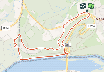

22 km | 29 km-effort
![Randonnée A pied Inconnu - [S2] Klusenberghangweg - Photo](https://media.geolcdn.com/t/1900/400/5f1f8fb9-4492-4816-a6a6-b31bfc037ad3.jpeg&format=pjpeg&maxdim=2)

Tous les sentiers balisés d’Europe GUIDE+


Application GPS de randonnée GRATUITE
 SityTrail
IGN / Instituts géographiques
SityTrail World
Le monde est à vous
Randonnée A pied de 5,3 km à découvrir à Rhénanie-du-Nord-Westphalie, Dortmund, Inconnu. Cette randonnée est proposée par SityTrail - itinéraires balisés pédestres.
Randonnée créée par Sauerländischer Gebirgsverein Bezirk Dortmund Ardey.
![Randonnée A pied Inconnu - [S2] Klusenberghangweg - Photo 1](https://media.geolcdn.com/t/2048/auto/5593201d-8896-4be9-a1fd-95978bfbd527.jpeg&format=jpg&maxdim=0 "Randonnée A pied Inconnu - [S2] Klusenberghangweg - Photo 1")
![Randonnée A pied Inconnu - [S2] Klusenberghangweg - Photo 2](https://media.geolcdn.com/t/2048/auto/91eb9446-02ed-4efd-b82d-3faecebc62d1.jpeg&format=jpg&maxdim=0 "Randonnée A pied Inconnu - [S2] Klusenberghangweg - Photo 2")
![Randonnée A pied Inconnu - [S2] Klusenberghangweg - Photo 3](https://media.geolcdn.com/t/2048/auto/81e0c4ae-54ea-4990-8781-1bd7e92f6399.jpeg&format=jpg&maxdim=0 "Randonnée A pied Inconnu - [S2] Klusenberghangweg - Photo 3")
![Randonnée A pied Inconnu - [S2] Klusenberghangweg - Photo 4](https://media.geolcdn.com/t/2048/auto/ddfb5857-138c-4fff-b388-dfb8e6b159bb.jpeg&format=jpg&maxdim=0 "Randonnée A pied Inconnu - [S2] Klusenberghangweg - Photo 4")
![Randonnée A pied Inconnu - [S2] Klusenberghangweg - Photo 5](https://media.geolcdn.com/t/2048/auto/00fa06c6-74c0-49d8-99a5-3b6ac5d9426e.jpeg&format=jpg&maxdim=0 "Randonnée A pied Inconnu - [S2] Klusenberghangweg - Photo 5")
![Randonnée A pied Inconnu - [S2] Klusenberghangweg - Photo 6](https://media.geolcdn.com/t/2048/auto/aa5cb832-0c18-4747-9552-6d89a4434091.jpeg&format=jpg&maxdim=0 "Randonnée A pied Inconnu - [S2] Klusenberghangweg - Photo 6")
![Randonnée A pied Inconnu - [S2] Klusenberghangweg - Photo 7](https://media.geolcdn.com/t/2048/auto/48a0ef8e-3704-4b57-a4cf-02a57ebc2595.jpeg&format=jpg&maxdim=0 "Randonnée A pied Inconnu - [S2] Klusenberghangweg - Photo 7")
![Randonnée A pied Inconnu - [S2] Klusenberghangweg - Photo 8](https://media.geolcdn.com/t/2048/auto/3858086d-bf9c-479b-9500-35a9a92851a8.jpeg&format=jpg&maxdim=0 "Randonnée A pied Inconnu - [S2] Klusenberghangweg - Photo 8")
![Randonnée A pied Inconnu - [S2] Klusenberghangweg - Photo 9](https://media.geolcdn.com/t/2048/auto/5f1f8fb9-4492-4816-a6a6-b31bfc037ad3.jpeg&format=jpg&maxdim=0 "Randonnée A pied Inconnu - [S2] Klusenberghangweg - Photo 9")
![Randonnée A pied Inconnu - [S2] Klusenberghangweg - Photo 10](https://media.geolcdn.com/t/2048/auto/26483a33-7972-46d2-b387-1dba689e4068.jpeg&format=jpg&maxdim=0 "Randonnée A pied Inconnu - [S2] Klusenberghangweg - Photo 10")
![Randonnée A pied Herdecke - [H6] Waldgebiete - Photo](https://media.geolcdn.com/t/375/260/fc184e54-a300-4080-bfb1-ee5af7544b8a.jpeg&format=jpg&maxdim=2)
A pied
![Randonnée A pied Herdecke - [H5] Westende - Kirchende - Ostende - Photo](https://media.geolcdn.com/t/375/260/a4190d68-4b9d-4b0c-86e3-91419be4a223.jpeg&format=jpg&maxdim=2)
A pied
![Randonnée A pied Herdecke - [H3] Hengsteysee und Teufelskanzel - Photo](https://media.geolcdn.com/t/375/260/48a0ef8e-3704-4b57-a4cf-02a57ebc2595.jpeg&format=jpg&maxdim=2)
A pied
![Randonnée A pied Herdecke - [H2] Ruhrtal zum Hickenstein - Photo](https://media.geolcdn.com/t/375/260/47dfa9a4-572d-4f34-b111-ae10e112c377.jpeg&format=jpg&maxdim=2)
A pied
![Randonnée A pied Herdecke - [H1] Viadukt und Nacken - Photo](https://media.geolcdn.com/t/375/260/0816fcff-a194-4a3a-b211-f59c276124fc.jpeg&format=jpg&maxdim=2)
A pied
A pied
A pied
A pied
A pied