![](/images/other/stat-length.png)
![Randonnée A pied Lauterbach - Bachtour Lauterbach - Photo](https://media.geolcdn.com/t/1900/400/e12d2b98-5b5e-4777-8c76-c02b36a75f64.jpeg&format=pjpeg&maxdim=2)
Bachtour Lauterbach
SityTrail - itinéraires balisés pédestres
Tous les sentiers balisés d’Europe GUIDE+
![Longueur](/images/other/stat-length.png)
![Altitude max](https://static1.geolcdn.com/siteimages/upload/files/1508320355ic_sort_altitude_max_24dp.png)
![Dénivelé positif](https://static1.geolcdn.com/siteimages/upload/files/1508320355ic_sort_den_pos_24dp.png)
![Km-Effort](/images/other/stat-length.png)
![Altitude min](https://static1.geolcdn.com/siteimages/upload/files/1508320355ic_sort_altitude_min_24dp.png)
![Dénivelé négatif](https://static1.geolcdn.com/siteimages/upload/files/1508320355ic_sort_den_neg_24dp.png)
![Boucle](https://static1.geolcdn.com/siteimages/upload/files/16400158638029165_repeat_loop_refresh_sync_direction_icon.png)
![A pied](https://static1.geolcdn.com/sitytour/trail-icons/100.png)
4h14
Difficulté : Facile
![Scannez ce code QR pour ouvrir la randonnée dans l'application SityTrail](https://capi.geolives.com/qq0zvz2zws4bq2lad0pu/sitytour/trails/3090003/qr.png?size=200)
Application GPS de randonnée GRATUITE
À propos
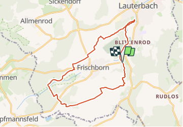
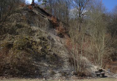
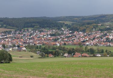
Randonnée A pied de 14,9 km à découvrir à Hesse, Vogelsbergkreis, Lauterbach. Cette randonnée est proposée par SityTrail - itinéraires balisés pédestres.
Description
Randonnée créée par Vogelsberger Höhenclub.
Symbole: Gruen-Rot stilisierter Vulkan-Vogelsberg auf weißem Hintergrund
Site web: http://www.extratouren-vogelsberg.de
Localisation
Commentaires
Randonnées à proximité
![Randonnée A pied Herbstein - Terrainkur 6 - Photo](https://media.geolcdn.com/t/375/260/993b5567-e18e-4be9-801f-117759fcc74e.jpeg&format=jpg&maxdim=2)
![A pied A pied](https://static1.geolcdn.com/sitytour/trail-icons/100.png)
A pied
![](/images/other/stat-length.png)
![](https://static1.geolcdn.com/siteimages/upload/files/16400158638029165_repeat_loop_refresh_sync_direction_icon.png)
![Randonnée A pied Herbstein - Terrainkur 2 - Photo](https://media.geolcdn.com/t/375/260/993b5567-e18e-4be9-801f-117759fcc74e.jpeg&format=jpg&maxdim=2)
![A pied A pied](https://static1.geolcdn.com/sitytour/trail-icons/100.png)
A pied
![](/images/other/stat-length.png)
![](https://static1.geolcdn.com/siteimages/upload/files/16400158638029165_repeat_loop_refresh_sync_direction_icon.png)
![Randonnée A pied Wartenberg - Wartenberger Zeitpfad - Photo](https://media.geolcdn.com/t/375/260/6e4aaab2-2bf0-411f-b8b2-78a38167c3ee.jpeg&format=jpg&maxdim=2)
![A pied A pied](https://static1.geolcdn.com/sitytour/trail-icons/100.png)
A pied
![](/images/other/stat-length.png)
![](https://static1.geolcdn.com/siteimages/upload/files/16400158638029165_repeat_loop_refresh_sync_direction_icon.png)
![Randonnée A pied Wartenberg - Historischer Rundweg Wartenberg - Photo](https://media.geolcdn.com/t/375/260/17f8a91d-0828-41f7-9303-6693ff3dcb27.jpeg&format=jpg&maxdim=2)
![A pied A pied](https://static1.geolcdn.com/sitytour/trail-icons/100.png)
A pied
![](/images/other/stat-length.png)
![](https://static1.geolcdn.com/siteimages/upload/files/16400158638029165_repeat_loop_refresh_sync_direction_icon.png)
![Randonnée A pied Wartenberg - Wartenberger Rundweg 3 - Photo](https://media.geolcdn.com/t/375/260/1352d35d-4d55-4f93-83ce-5fad4ffe5433.jpeg&format=jpg&maxdim=2)
![A pied A pied](https://static1.geolcdn.com/sitytour/trail-icons/100.png)
A pied
![](/images/other/stat-length.png)
![](https://static1.geolcdn.com/siteimages/upload/files/16400158638029165_repeat_loop_refresh_sync_direction_icon.png)
![Randonnée A pied Wartenberg - Wartenberger Rundweg 2 - Photo](https://media.geolcdn.com/t/375/260/c75043f0-cb95-4761-9ad9-59135367539d.jpeg&format=jpg&maxdim=2)
![A pied A pied](https://static1.geolcdn.com/sitytour/trail-icons/100.png)
A pied
![](/images/other/stat-length.png)
![](https://static1.geolcdn.com/siteimages/upload/files/16400158638029165_repeat_loop_refresh_sync_direction_icon.png)
![Randonnée A pied Wartenberg - Wartenberger Rundweg 5 - Photo](https://media.geolcdn.com/t/375/260/c75043f0-cb95-4761-9ad9-59135367539d.jpeg&format=jpg&maxdim=2)
![A pied A pied](https://static1.geolcdn.com/sitytour/trail-icons/100.png)
A pied
![](/images/other/stat-length.png)
![](https://static1.geolcdn.com/siteimages/upload/files/16400158638029165_repeat_loop_refresh_sync_direction_icon.png)
![Randonnée A pied Wartenberg - Wartenberger Panorama-Weg - Photo](https://media.geolcdn.com/t/375/260/6e4aaab2-2bf0-411f-b8b2-78a38167c3ee.jpeg&format=jpg&maxdim=2)
![A pied A pied](https://static1.geolcdn.com/sitytour/trail-icons/100.png)
A pied
![](/images/other/stat-length.png)
![](https://static1.geolcdn.com/siteimages/upload/files/16400158638029165_repeat_loop_refresh_sync_direction_icon.png)
![Randonnée A pied Lauterbach - Lauterbach - Herbstein - Photo](https://media.geolcdn.com/t/375/260/602eea6a-2380-4776-a0ab-670335ec329b.jpeg&format=jpg&maxdim=2)
![A pied A pied](https://static1.geolcdn.com/sitytour/trail-icons/100.png)
A pied
![](/images/other/stat-length.png)
![](https://static1.geolcdn.com/siteimages/upload/files/16400158638029165_repeat_loop_refresh_sync_direction_icon.png)