![](/images/other/stat-length.png)
![Randonnée A pied Helmstedt - Lappwald Rundwanderweg 1 - Photo](https://media.geolcdn.com/t/1900/400/5e2cc03e-716e-464f-9bb5-7251531e9e49.jpeg&format=pjpeg&maxdim=2)
Lappwald Rundwanderweg 1
SityTrail - itinéraires balisés pédestres
Tous les sentiers balisés d’Europe GUIDE+
![Longueur](/images/other/stat-length.png)
Longueur
3,5 km
![Altitude max](https://static1.geolcdn.com/siteimages/upload/files/1508320355ic_sort_altitude_max_24dp.png)
Altitude max
191 m
![Dénivelé positif](https://static1.geolcdn.com/siteimages/upload/files/1508320355ic_sort_den_pos_24dp.png)
Dénivelé positif
51 m
![Km-Effort](/images/other/stat-length.png)
Km-Effort
4,1 km
![Altitude min](https://static1.geolcdn.com/siteimages/upload/files/1508320355ic_sort_altitude_min_24dp.png)
Altitude min
146 m
![Dénivelé négatif](https://static1.geolcdn.com/siteimages/upload/files/1508320355ic_sort_den_neg_24dp.png)
Dénivelé négatif
49 m
![Boucle](https://static1.geolcdn.com/siteimages/upload/files/16400158638029165_repeat_loop_refresh_sync_direction_icon.png)
Boucle
Non
Balise
Date de création :
2022-02-11 13:11:05.304
Dernière modification :
2022-02-11 13:11:05.304
![A pied](https://static1.geolcdn.com/sitytour/trail-icons/100.png)
56m
Difficulté : Facile
![Scannez ce code QR pour ouvrir la randonnée dans l'application SityTrail](https://capi.geolives.com/qq0zvz2zws4bq2lad0pu/sitytour/trails/3089419/qr.png?size=200)
Application GPS de randonnée GRATUITE
À propos
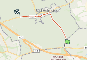
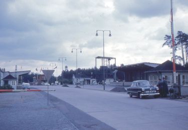
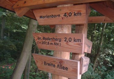
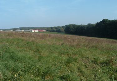
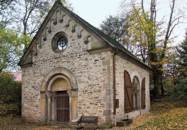
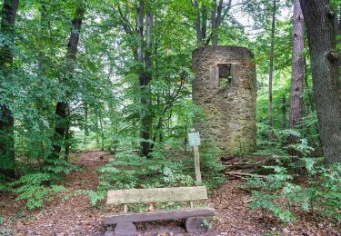
Randonnée A pied de 3,5 km à découvrir à Basse-Saxe, Helmstedt (arrondissement), Helmstedt. Cette randonnée est proposée par SityTrail - itinéraires balisés pédestres.
Description
Randonnée créée par Naturpark Elm-Lappwald.
Symbole: schwarze 1 auf weißem Quadrat
Localisation
Pays :
Allemagne
Région :
Basse-Saxe
Département/Province :
Helmstedt (arrondissement)
Commune :
Helmstedt
Localité :
Unknown
Départ:(Dec)
Départ:(UTM)
641757 ; 5787551 (32U) N.
Commentaires
Randonnées à proximité
![Randonnée A pied Beendorf - Lappwald Rundwanderweg 19 - Photo](https://media.geolcdn.com/t/375/260/2bf3e6f9-52b4-44ec-a147-141bad110d1b.jpeg&format=jpg&maxdim=2)
![A pied A pied](https://static1.geolcdn.com/sitytour/trail-icons/100.png)
Lappwald Rundwanderweg 19
A pied
Facile
Beendorf,
Saxe-Anhalt,
Börde,
Allemagne
![](/images/other/stat-length.png)
5,8 km | 6,8 km-effort
1h 32min
![](https://static1.geolcdn.com/siteimages/upload/files/16400158638029165_repeat_loop_refresh_sync_direction_icon.png)
Non
![Randonnée A pied Beendorf - Lappwald Rundwanderweg 18 - Photo](https://media.geolcdn.com/t/375/260/9783ffb9-1fe0-4b38-9f71-7fb6430cc314.jpeg&format=jpg&maxdim=2)
![A pied A pied](https://static1.geolcdn.com/sitytour/trail-icons/100.png)
Lappwald Rundwanderweg 18
A pied
Facile
Beendorf,
Saxe-Anhalt,
Börde,
Allemagne
![](/images/other/stat-length.png)
5,9 km | 7,3 km-effort
1h 38min
![](https://static1.geolcdn.com/siteimages/upload/files/16400158638029165_repeat_loop_refresh_sync_direction_icon.png)
Non
![Randonnée A pied Harbke - Lappwald Rundwanderweg 24 - Photo](https://media.geolcdn.com/t/375/260/5e2cc03e-716e-464f-9bb5-7251531e9e49.jpeg&format=jpg&maxdim=2)
![A pied A pied](https://static1.geolcdn.com/sitytour/trail-icons/100.png)
Lappwald Rundwanderweg 24
A pied
Facile
Harbke,
Saxe-Anhalt,
Börde,
Allemagne
![](/images/other/stat-length.png)
4,4 km | 5,3 km-effort
1h 12min
![](https://static1.geolcdn.com/siteimages/upload/files/16400158638029165_repeat_loop_refresh_sync_direction_icon.png)
Non
![Randonnée A pied Sommersdorf - Lappwald Rundwanderweg 28 - Photo](https://media.geolcdn.com/t/375/260/7b461665-6a8f-400b-ab8c-65c8d71dc9c4.jpeg&format=jpg&maxdim=2)
![A pied A pied](https://static1.geolcdn.com/sitytour/trail-icons/100.png)
Lappwald Rundwanderweg 28
A pied
Facile
Sommersdorf,
Saxe-Anhalt,
Börde,
Allemagne
![](/images/other/stat-length.png)
4,2 km | 4,9 km-effort
1h 7min
![](https://static1.geolcdn.com/siteimages/upload/files/16400158638029165_repeat_loop_refresh_sync_direction_icon.png)
Non
![Randonnée A pied Harbke - Lappwald Rundwanderweg 27 - Photo](https://media.geolcdn.com/t/375/260/3f74f975-1e9e-45ec-a545-b2071c368a5b.jpeg&format=jpg&maxdim=2)
![A pied A pied](https://static1.geolcdn.com/sitytour/trail-icons/100.png)
Lappwald Rundwanderweg 27
A pied
Facile
Harbke,
Saxe-Anhalt,
Börde,
Allemagne
![](/images/other/stat-length.png)
5,4 km | 6,5 km-effort
1h 27min
![](https://static1.geolcdn.com/siteimages/upload/files/16400158638029165_repeat_loop_refresh_sync_direction_icon.png)
Non
![Randonnée A pied Sommersdorf - Lappwald Rundwanderweg 26 - Photo](https://media.geolcdn.com/t/375/260/dfb987a7-961b-4ee0-a2d4-f41d06fb954d.jpeg&format=jpg&maxdim=2)
![A pied A pied](https://static1.geolcdn.com/sitytour/trail-icons/100.png)
Lappwald Rundwanderweg 26
A pied
Facile
Sommersdorf,
Saxe-Anhalt,
Börde,
Allemagne
![](/images/other/stat-length.png)
8,1 km | 9,5 km-effort
2h 10min
![](https://static1.geolcdn.com/siteimages/upload/files/16400158638029165_repeat_loop_refresh_sync_direction_icon.png)
Non
![Randonnée A pied Helmstedt - Lappwald Rundwanderweg 7 - Photo](https://media.geolcdn.com/t/375/260/b5ca48e1-401f-4a48-ad25-8fd40f4f809e.jpeg&format=jpg&maxdim=2)
![A pied A pied](https://static1.geolcdn.com/sitytour/trail-icons/100.png)
Lappwald Rundwanderweg 7
A pied
Facile
Helmstedt,
Basse-Saxe,
Helmstedt (arrondissement),
Allemagne
![](/images/other/stat-length.png)
4,1 km | 4,9 km-effort
1h 6min
![](https://static1.geolcdn.com/siteimages/upload/files/16400158638029165_repeat_loop_refresh_sync_direction_icon.png)
Oui
![Randonnée A pied Helmstedt - Lappwald Rundwanderweg 2 - Photo](https://media.geolcdn.com/t/375/260/5897bc14-82f8-4235-8323-3be9e68c362f.jpeg&format=jpg&maxdim=2)
![A pied A pied](https://static1.geolcdn.com/sitytour/trail-icons/100.png)
Lappwald Rundwanderweg 2
A pied
Facile
Helmstedt,
Basse-Saxe,
Helmstedt (arrondissement),
Allemagne
![](/images/other/stat-length.png)
4 km | 4,5 km-effort
1h 2min
![](https://static1.geolcdn.com/siteimages/upload/files/16400158638029165_repeat_loop_refresh_sync_direction_icon.png)
Non
![Randonnée A pied Helmstedt - Drillingskiefer Rundweg - Photo](https://media.geolcdn.com/t/375/260/b5ca48e1-401f-4a48-ad25-8fd40f4f809e.jpeg&format=jpg&maxdim=2)
![A pied A pied](https://static1.geolcdn.com/sitytour/trail-icons/100.png)
Drillingskiefer Rundweg
A pied
Facile
Helmstedt,
Basse-Saxe,
Helmstedt (arrondissement),
Allemagne
![](/images/other/stat-length.png)
6,3 km | 7,5 km-effort
1h 41min
![](https://static1.geolcdn.com/siteimages/upload/files/16400158638029165_repeat_loop_refresh_sync_direction_icon.png)
Non