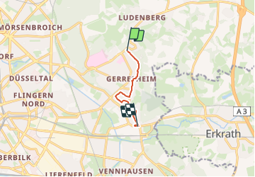
![](/images/other/stat-length.png)
![Randonnée A pied Inconnu - Industriepfad Düsseldorf-Gerresheim - Photo](https://media.geolcdn.com/t/1900/400/d0cb714a-becf-4430-8992-a4b859ea4a1c.jpeg&format=pjpeg&maxdim=2)
Industriepfad Düsseldorf-Gerresheim
SityTrail - itinéraires balisés pédestres
Tous les sentiers balisés d’Europe GUIDE+
![Longueur](/images/other/stat-length.png)
![Altitude max](https://static1.geolcdn.com/siteimages/upload/files/1508320355ic_sort_altitude_max_24dp.png)
![Dénivelé positif](https://static1.geolcdn.com/siteimages/upload/files/1508320355ic_sort_den_pos_24dp.png)
![Km-Effort](/images/other/stat-length.png)
![Altitude min](https://static1.geolcdn.com/siteimages/upload/files/1508320355ic_sort_altitude_min_24dp.png)
![Dénivelé négatif](https://static1.geolcdn.com/siteimages/upload/files/1508320355ic_sort_den_neg_24dp.png)
![Boucle](https://static1.geolcdn.com/siteimages/upload/files/16400158638029165_repeat_loop_refresh_sync_direction_icon.png)
![A pied](https://static1.geolcdn.com/sitytour/trail-icons/100.png)
1h06
Difficulté : Facile
![Scannez ce code QR pour ouvrir la randonnée dans l'application SityTrail](https://capi.geolives.com/qq0zvz2zws4bq2lad0pu/sitytour/trails/3089405/qr.png?size=200)
Application GPS de randonnée GRATUITE
À propos
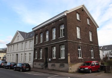
Randonnée A pied de 4,5 km à découvrir à Rhénanie-du-Nord-Westphalie, Düsseldorf, Inconnu. Cette randonnée est proposée par SityTrail - itinéraires balisés pédestres.
Description
Randonnée créée par Förderkreis Industriepfad Düsseldorf-Gerresheim e.V..
Der Industriepfad kann beim Ringofen noch nicht in seiner endgültigen Führung eingegeben werden, da noch Wege im Neubaugebiet fehlen. Weithin fehlen noch die meisten Informationsstelen.
Localisation
Commentaires
Randonnées à proximité
![Randonnée A pied Erkrath - Neanderlandsteig Entdeckerschleife](https://media.geolcdn.com/t/375/260/f0a4c676-b45d-44ca-9d2f-c9554313404f.jpeg&format=jpg&maxdim=2)
![A pied A pied](https://static1.geolcdn.com/sitytour/trail-icons/100.png)
A pied
![](/images/other/stat-length.png)
![](https://static1.geolcdn.com/siteimages/upload/files/16400158638029165_repeat_loop_refresh_sync_direction_icon.png)
![Randonnée A pied Inconnu - Aaperwald Rundweg A2 - Photo](https://media.geolcdn.com/t/375/260/ca0b790a-7d1f-4d5e-b73b-8c860418e106.jpeg&format=jpg&maxdim=2)
![A pied A pied](https://static1.geolcdn.com/sitytour/trail-icons/100.png)
A pied
![](/images/other/stat-length.png)
![](https://static1.geolcdn.com/siteimages/upload/files/16400158638029165_repeat_loop_refresh_sync_direction_icon.png)
![Randonnée A pied Inconnu - Rechteck Gerresheim-Unterbach - Photo](https://media.geolcdn.com/t/375/260/533e878e-0bfb-411b-a976-bd0edf99eb3a.jpeg&format=jpg&maxdim=2)
![A pied A pied](https://static1.geolcdn.com/sitytour/trail-icons/100.png)
A pied
![](/images/other/stat-length.png)
![](https://static1.geolcdn.com/siteimages/upload/files/16400158638029165_repeat_loop_refresh_sync_direction_icon.png)
![Randonnée A pied Erkrath - Rechteck Erkrath-Eller - Photo](https://media.geolcdn.com/t/375/260/869ed9d6-13d5-459e-9f12-6811fc83e378.jpeg&format=jpg&maxdim=2)
![A pied A pied](https://static1.geolcdn.com/sitytour/trail-icons/100.png)
A pied
![](/images/other/stat-length.png)
![](https://static1.geolcdn.com/siteimages/upload/files/16400158638029165_repeat_loop_refresh_sync_direction_icon.png)
![Randonnée A pied Erkrath - Doppelbalken Rund um Alt-Erkrath - Photo](https://media.geolcdn.com/t/375/260/fa6b4399-24c9-49f3-9a97-8e33e8c2dfbf.jpeg&format=jpg&maxdim=2)
![A pied A pied](https://static1.geolcdn.com/sitytour/trail-icons/100.png)
A pied
![](/images/other/stat-length.png)
![](https://static1.geolcdn.com/siteimages/upload/files/16400158638029165_repeat_loop_refresh_sync_direction_icon.png)
![Randonnée A pied Inconnu - Aaperwald Rundweg A1 - Photo](https://media.geolcdn.com/t/375/260/4d07ddde-f9f0-4046-a6db-7f628bc2b8e3.jpeg&format=jpg&maxdim=2)
![A pied A pied](https://static1.geolcdn.com/sitytour/trail-icons/100.png)
A pied
![](/images/other/stat-length.png)
![](https://static1.geolcdn.com/siteimages/upload/files/16400158638029165_repeat_loop_refresh_sync_direction_icon.png)
![Randonnée A pied Inconnu - Aaperwald Rundweg A4 - Photo](https://media.geolcdn.com/t/375/260/cc10fb3b-0b55-4811-9c85-f69bb325738c.jpeg&format=jpg&maxdim=2)
![A pied A pied](https://static1.geolcdn.com/sitytour/trail-icons/100.png)
A pied
![](/images/other/stat-length.png)
![](https://static1.geolcdn.com/siteimages/upload/files/16400158638029165_repeat_loop_refresh_sync_direction_icon.png)
![Randonnée A pied Inconnu - [D] Düsseldorfer Weg - Photo](https://media.geolcdn.com/t/375/260/02398625-9783-4a6b-913e-ce79bc76d8b1.jpeg&format=jpg&maxdim=2)
![A pied A pied](https://static1.geolcdn.com/sitytour/trail-icons/100.png)
A pied
![](/images/other/stat-length.png)
![](https://static1.geolcdn.com/siteimages/upload/files/16400158638029165_repeat_loop_refresh_sync_direction_icon.png)
![Randonnée A pied Erkrath - Vollquadrat Gerresheim-Neanderthal - Photo](https://media.geolcdn.com/t/375/260/d1572fd1-0357-4966-88ad-318e5641457b.jpeg&format=jpg&maxdim=2)
![A pied A pied](https://static1.geolcdn.com/sitytour/trail-icons/100.png)
A pied
![](/images/other/stat-length.png)
![](https://static1.geolcdn.com/siteimages/upload/files/16400158638029165_repeat_loop_refresh_sync_direction_icon.png)