![](/images/other/stat-length.png)
![Randonnée A pied Ettringen - Vulkanpfad - Photo](https://media.geolcdn.com/t/1900/400/a9bcde2f-4e83-4d1c-b1a4-a118255fff13.jpeg&format=pjpeg&maxdim=2)
Vulkanpfad
SityTrail - itinéraires balisés pédestres
Tous les sentiers balisés d’Europe GUIDE+
![Longueur](/images/other/stat-length.png)
Longueur
6,7 km
![Altitude max](https://static1.geolcdn.com/siteimages/upload/files/1508320355ic_sort_altitude_max_24dp.png)
Altitude max
409 m
![Dénivelé positif](https://static1.geolcdn.com/siteimages/upload/files/1508320355ic_sort_den_pos_24dp.png)
Dénivelé positif
206 m
![Km-Effort](/images/other/stat-length.png)
Km-Effort
9,4 km
![Altitude min](https://static1.geolcdn.com/siteimages/upload/files/1508320355ic_sort_altitude_min_24dp.png)
Altitude min
283 m
![Dénivelé négatif](https://static1.geolcdn.com/siteimages/upload/files/1508320355ic_sort_den_neg_24dp.png)
Dénivelé négatif
198 m
![Boucle](https://static1.geolcdn.com/siteimages/upload/files/16400158638029165_repeat_loop_refresh_sync_direction_icon.png)
Boucle
Oui
Balise
Date de création :
2022-02-11 13:02:16.277
Dernière modification :
2022-02-11 13:02:16.277
![A pied](https://static1.geolcdn.com/sitytour/trail-icons/100.png)
2h07
Difficulté : Facile
![Scannez ce code QR pour ouvrir la randonnée dans l'application SityTrail](https://capi.geolives.com/qq0zvz2zws4bq2lad0pu/sitytour/trails/3088969/qr.png?size=200)
Application GPS de randonnée GRATUITE
À propos
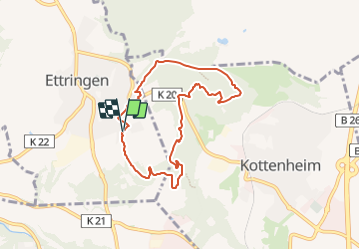
Randonnée A pied de 6,7 km à découvrir à Rhénanie-Palatinat, Landkreis Mayen-Koblenz, Ettringen. Cette randonnée est proposée par SityTrail - itinéraires balisés pédestres.
Description
Randonnée créée par Projektbüro Traumpfade der Rhein-Mosel-Eifel-Touristik.
Symbole: Oranger Hintergrund mit weißem Weg - Traumpfade
Localisation
Pays :
Allemagne
Région :
Rhénanie-Palatinat
Département/Province :
Landkreis Mayen-Koblenz
Commune :
Ettringen
Localité :
Unknown
Départ:(Dec)
Départ:(UTM)
373925 ; 5579251 (32U) N.
Commentaires
Randonnées à proximité
![Randonnée A pied Rieden - Traumpfad Riedener See - Photo](https://media.geolcdn.com/t/375/260/0eee0a8d-7b40-4ca8-b00c-c42f3103e77d.jpeg&format=jpg&maxdim=2)
![A pied A pied](https://static1.geolcdn.com/sitytour/trail-icons/100.png)
Traumpfad Riedener See
A pied
Facile
Rieden,
Rhénanie-Palatinat,
Landkreis Mayen-Koblenz,
Allemagne
![](/images/other/stat-length.png)
11,4 km | 16 km-effort
3h 38min
![](https://static1.geolcdn.com/siteimages/upload/files/16400158638029165_repeat_loop_refresh_sync_direction_icon.png)
Non
![Randonnée A pied Mayen - Eifel-Traumpfad Förstersteig - Photo](https://media.geolcdn.com/t/375/260/8b43a2e6-3bc2-41b8-be4f-03d51604523a.jpeg&format=jpg&maxdim=2)
![A pied A pied](https://static1.geolcdn.com/sitytour/trail-icons/100.png)
Eifel-Traumpfad Förstersteig
A pied
Moyen
Mayen,
Rhénanie-Palatinat,
Landkreis Mayen-Koblenz,
Allemagne
![](/images/other/stat-length.png)
14,5 km | 22 km-effort
5h 2min
![](https://static1.geolcdn.com/siteimages/upload/files/16400158638029165_repeat_loop_refresh_sync_direction_icon.png)
Oui
![Randonnée A pied Mendig - Vier-Berge-Tour - Photo](https://media.geolcdn.com/t/375/260/dc19cd52-1308-4d2b-b462-6e3be21ea316.jpeg&format=jpg&maxdim=2)
![A pied A pied](https://static1.geolcdn.com/sitytour/trail-icons/100.png)
Vier-Berge-Tour
A pied
Facile
Mendig,
Rhénanie-Palatinat,
Landkreis Mayen-Koblenz,
Allemagne
![](/images/other/stat-length.png)
4,6 km | 6 km-effort
1h 21min
![](https://static1.geolcdn.com/siteimages/upload/files/16400158638029165_repeat_loop_refresh_sync_direction_icon.png)
Non
![Randonnée A pied Mayen - DE-12 - Photo](https://media.geolcdn.com/t/375/260/4f997951-8cb7-408a-bc6d-6ea010a1854e.jpeg&format=jpg&maxdim=2)
![A pied A pied](https://static1.geolcdn.com/sitytour/trail-icons/100.png)
DE-12
A pied
Facile
Mayen,
Rhénanie-Palatinat,
Landkreis Mayen-Koblenz,
Allemagne
![](/images/other/stat-length.png)
5,4 km | 8,2 km-effort
1h 51min
![](https://static1.geolcdn.com/siteimages/upload/files/16400158638029165_repeat_loop_refresh_sync_direction_icon.png)
Non
![Randonnée A pied Mayen - DE-9 - Photo](https://media.geolcdn.com/t/375/260/4f997951-8cb7-408a-bc6d-6ea010a1854e.jpeg&format=jpg&maxdim=2)
![A pied A pied](https://static1.geolcdn.com/sitytour/trail-icons/100.png)
DE-9
A pied
Facile
Mayen,
Rhénanie-Palatinat,
Landkreis Mayen-Koblenz,
Allemagne
![](/images/other/stat-length.png)
5,1 km | 7,5 km-effort
1h 41min
![](https://static1.geolcdn.com/siteimages/upload/files/16400158638029165_repeat_loop_refresh_sync_direction_icon.png)
Non
![Randonnée A pied Mayen - DE-11 - Photo](https://media.geolcdn.com/t/375/260/4f997951-8cb7-408a-bc6d-6ea010a1854e.jpeg&format=jpg&maxdim=2)
![A pied A pied](https://static1.geolcdn.com/sitytour/trail-icons/100.png)
DE-11
A pied
Facile
Mayen,
Rhénanie-Palatinat,
Landkreis Mayen-Koblenz,
Allemagne
![](/images/other/stat-length.png)
3,6 km | 6 km-effort
1h 22min
![](https://static1.geolcdn.com/siteimages/upload/files/16400158638029165_repeat_loop_refresh_sync_direction_icon.png)
Non