![](/images/other/stat-length.png)
![Randonnée A pied Unknown - Doppelbalken Krefeld Rheinstraße - Bockum - Photo](https://media.geolcdn.com/t/1900/400/ext.pjpeg?maxdim=2&url=https%3A%2F%2Fmedia.geolcdn.com%2Ff%2F6f3acc38-0792-4866-9192-eb39f44d8b23.jpeg)
Doppelbalken Krefeld Rheinstraße - Bockum
SityTrail - itinéraires balisés pédestres
Tous les sentiers balisés d’Europe PRO
![Longueur](/images/other/stat-length.png)
Longueur
8,9 km
![Altitude max](https://static1.geolcdn.com/siteimages/upload/files/1508320355ic_sort_altitude_max_24dp.png)
Altitude max
51 m
![Dénivelé positif](https://static1.geolcdn.com/siteimages/upload/files/1508320355ic_sort_den_pos_24dp.png)
Dénivelé positif
55 m
![Km-Effort](/images/other/stat-length.png)
Km-Effort
9,7 km
![Altitude min](https://static1.geolcdn.com/siteimages/upload/files/1508320355ic_sort_altitude_min_24dp.png)
Altitude min
30 m
![Dénivelé négatif](https://static1.geolcdn.com/siteimages/upload/files/1508320355ic_sort_den_neg_24dp.png)
Dénivelé négatif
57 m
![Boucle](https://static1.geolcdn.com/siteimages/upload/files/16400158638029165_repeat_loop_refresh_sync_direction_icon.png)
Boucle
Non
Balise
Date de création :
2022-02-11 13:01:58.66
Dernière modification :
2022-02-11 13:01:58.66
![A pied](https://static1.geolcdn.com/sitytour/trail-icons/100.png)
2h11
Difficulté : Facile
![Scannez ce code QR pour ouvrir la randonnée dans l'application SityTrail](https://capi.geolives.com/qq0zvz2zws4bq2lad0pu/sitytour/trails/3088943/qr.png?size=200)
Application GPS de randonnée GRATUITE
À propos
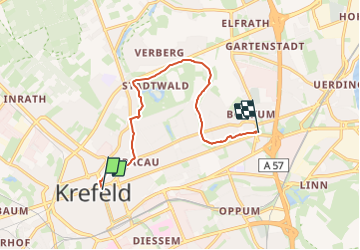
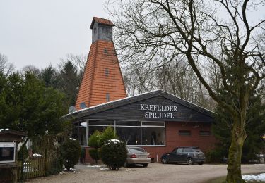
Randonnée A pied de 8,9 km à découvrir à Rhénanie-du-Nord-Westphalie, Krefeld. Cette randonnée est proposée par SityTrail - itinéraires balisés pédestres.
Description
Randonnée créée par Verein Niederrhein.
2016 zwischen Hauptbahnhof und Rheinstraße aufgelassen. Wegzeichen sind entfernt.
Symbole: =
Localisation
Pays :
Allemagne
Région :
Rhénanie-du-Nord-Westphalie
Département/Province :
Krefeld
Commune :
Unknown
Localité :
Unknown
Départ:(Dec)
Départ:(UTM)
330432 ; 5689751 (32U) N.
Commentaires
Randonnées à proximité
![Randonnée A pied - Forstwald Rundweg A1 - Photo](https://media.geolcdn.com/t/375/260/ext.jpg?maxdim=2&url=https%3A%2F%2Fmedia.geolcdn.com%2Ff%2Fa22ee63f-8b53-4b52-bc2f-b77b79c24112.jpeg)
![A pied A pied](https://static1.geolcdn.com/sitytour/trail-icons/100.png)
Forstwald Rundweg A1
A pied
Facile
,
Rhénanie-du-Nord-Westphalie,
Krefeld,
Allemagne
![](/images/other/stat-length.png)
4,9 km | 5,5 km-effort
1h 14min
![](https://static1.geolcdn.com/siteimages/upload/files/16400158638029165_repeat_loop_refresh_sync_direction_icon.png)
Oui
![Randonnée A pied - Orbroich Rundweg A3 - Photo](https://media.geolcdn.com/t/375/260/ext.jpg?maxdim=2&url=https%3A%2F%2Fmedia.geolcdn.com%2Ff%2F2e127597-41d2-427d-8d12-46baff77e110.jpeg)
![A pied A pied](https://static1.geolcdn.com/sitytour/trail-icons/100.png)
Orbroich Rundweg A3
A pied
Facile
,
Rhénanie-du-Nord-Westphalie,
Krefeld,
Allemagne
![](/images/other/stat-length.png)
9,1 km | 9,6 km-effort
2h 10min
![](https://static1.geolcdn.com/siteimages/upload/files/16400158638029165_repeat_loop_refresh_sync_direction_icon.png)
Oui
![Randonnée A pied - Hülser Bruch Rundweg A4 - Photo](https://media.geolcdn.com/t/375/260/ext.jpg?maxdim=2&url=https%3A%2F%2Fmedia.geolcdn.com%2Ff%2F2dcec02e-11ae-4fbf-b5c7-d95c06f4ac0a.jpeg)
![A pied A pied](https://static1.geolcdn.com/sitytour/trail-icons/100.png)
Hülser Bruch Rundweg A4
A pied
Facile
,
Rhénanie-du-Nord-Westphalie,
Krefeld,
Allemagne
![](/images/other/stat-length.png)
5,9 km | 6,9 km-effort
1h 34min
![](https://static1.geolcdn.com/siteimages/upload/files/16400158638029165_repeat_loop_refresh_sync_direction_icon.png)
Oui
![Randonnée A pied - Winkel Schroersdyk - Waldwinkel - Photo](https://media.geolcdn.com/t/375/260/ext.jpg?maxdim=2&url=https%3A%2F%2Fmedia.geolcdn.com%2Ff%2F5ae10d6d-8cd7-41bc-9b25-00df8b671af9.jpeg)
![A pied A pied](https://static1.geolcdn.com/sitytour/trail-icons/100.png)
Winkel Schroersdyk - Waldwinkel
A pied
Facile
,
Rhénanie-du-Nord-Westphalie,
Krefeld,
Allemagne
![](/images/other/stat-length.png)
9,6 km | 11 km-effort
2h 30min
![](https://static1.geolcdn.com/siteimages/upload/files/16400158638029165_repeat_loop_refresh_sync_direction_icon.png)
Non
![Randonnée A pied - Kreis Johansenweg - Photo](https://media.geolcdn.com/t/375/260/ext.jpg?maxdim=2&url=https%3A%2F%2Fmedia.geolcdn.com%2Ff%2F42bc7ff4-1b5d-452f-8ea8-dd9ff6b31900.jpeg)
![A pied A pied](https://static1.geolcdn.com/sitytour/trail-icons/100.png)
Kreis Johansenweg
A pied
Facile
,
Rhénanie-du-Nord-Westphalie,
Krefeld,
Allemagne
![](/images/other/stat-length.png)
6,6 km | 7,6 km-effort
1h 43min
![](https://static1.geolcdn.com/siteimages/upload/files/16400158638029165_repeat_loop_refresh_sync_direction_icon.png)
Non
![Randonnée A pied - Balken Heinrich-Mertens-Weg - Photo](https://media.geolcdn.com/t/375/260/ext.jpg?maxdim=2&url=https%3A%2F%2Fmedia.geolcdn.com%2Ff%2F2dcec02e-11ae-4fbf-b5c7-d95c06f4ac0a.jpeg)
![A pied A pied](https://static1.geolcdn.com/sitytour/trail-icons/100.png)
Balken Heinrich-Mertens-Weg
A pied
Facile
,
Rhénanie-du-Nord-Westphalie,
Krefeld,
Allemagne
![](/images/other/stat-length.png)
5,5 km | 6,2 km-effort
1h 25min
![](https://static1.geolcdn.com/siteimages/upload/files/16400158638029165_repeat_loop_refresh_sync_direction_icon.png)
Non
![Randonnée A pied - J Johann-Junkers-Weg - Photo](https://media.geolcdn.com/t/375/260/ext.jpg?maxdim=2&url=https%3A%2F%2Fmedia.geolcdn.com%2Ff%2F6b33fee0-d8a9-4516-8210-8e5775d9dd5b.jpeg)
![A pied A pied](https://static1.geolcdn.com/sitytour/trail-icons/100.png)
J Johann-Junkers-Weg
A pied
Facile
,
Rhénanie-du-Nord-Westphalie,
Krefeld,
Allemagne
![](/images/other/stat-length.png)
3,6 km | 4,3 km-effort
58min
![](https://static1.geolcdn.com/siteimages/upload/files/16400158638029165_repeat_loop_refresh_sync_direction_icon.png)
Non
![Randonnée A pied Meerbusch - Strümp Rundweg A10 - Photo](https://media.geolcdn.com/t/375/260/ext.jpg?maxdim=2&url=https%3A%2F%2Fstatic1.geolcdn.com%2Fsiteimages%2Fupload%2Ffiles%2F1545311037marcheuse_200dpi.jpg)
![A pied A pied](https://static1.geolcdn.com/sitytour/trail-icons/100.png)
Strümp Rundweg A10
A pied
Facile
Meerbusch,
Rhénanie-du-Nord-Westphalie,
Rhein-Kreis Neuss,
Allemagne
![](/images/other/stat-length.png)
6,4 km | 6,9 km-effort
1h 34min
![](https://static1.geolcdn.com/siteimages/upload/files/16400158638029165_repeat_loop_refresh_sync_direction_icon.png)
Oui