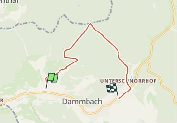
![](/images/other/stat-length.png)
![Randonnée A pied Dammbach - Kulturweg Dammbach - Photo](https://media.geolcdn.com/t/1900/400/93a97ab8-0629-4862-835c-3ccba16e65be.jpeg&format=pjpeg&maxdim=2)
Kulturweg Dammbach
SityTrail - itinéraires balisés pédestres
Tous les sentiers balisés d’Europe GUIDE+
![Longueur](/images/other/stat-length.png)
![Altitude max](https://static1.geolcdn.com/siteimages/upload/files/1508320355ic_sort_altitude_max_24dp.png)
![Dénivelé positif](https://static1.geolcdn.com/siteimages/upload/files/1508320355ic_sort_den_pos_24dp.png)
![Km-Effort](/images/other/stat-length.png)
![Altitude min](https://static1.geolcdn.com/siteimages/upload/files/1508320355ic_sort_altitude_min_24dp.png)
![Dénivelé négatif](https://static1.geolcdn.com/siteimages/upload/files/1508320355ic_sort_den_neg_24dp.png)
![Boucle](https://static1.geolcdn.com/siteimages/upload/files/16400158638029165_repeat_loop_refresh_sync_direction_icon.png)
![A pied](https://static1.geolcdn.com/sitytour/trail-icons/100.png)
1h49
Difficulté : Facile
![Scannez ce code QR pour ouvrir la randonnée dans l'application SityTrail](https://capi.geolives.com/qq0zvz2zws4bq2lad0pu/sitytour/trails/3088821/qr.png?size=200)
Application GPS de randonnée GRATUITE
À propos
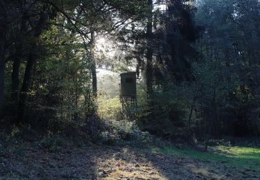
Randonnée A pied de 5,1 km à découvrir à Bavière, Landkreis Aschaffenburg, Dammbach. Cette randonnée est proposée par SityTrail - itinéraires balisés pédestres.
Description
Randonnée créée par Archäologisches Spessartprojekt.
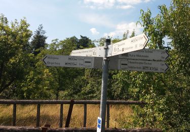
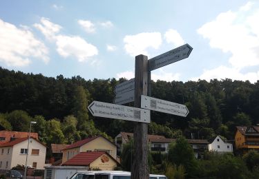
Symbole: Gelbes EU-Schiffchen auf blauem Grund
Site web: https://www.spessartprojekt.de/?page_id=12879
Localisation
Commentaires
Randonnées à proximité
![Randonnée A pied Dammbach - Ortswanderweg Dammbach 1 - Photo](https://media.geolcdn.com/t/375/260/93a97ab8-0629-4862-835c-3ccba16e65be.jpeg&format=jpg&maxdim=2)
![A pied A pied](https://static1.geolcdn.com/sitytour/trail-icons/100.png)
A pied
![](/images/other/stat-length.png)
![](https://static1.geolcdn.com/siteimages/upload/files/16400158638029165_repeat_loop_refresh_sync_direction_icon.png)
![Randonnée A pied Eschau - Roter Hase Rundwanderweg Eschau - Photo](https://media.geolcdn.com/t/375/260/f18cf4e5-d28f-4d88-a667-aeffc283b576.jpeg&format=jpg&maxdim=2)
![A pied A pied](https://static1.geolcdn.com/sitytour/trail-icons/100.png)
A pied
![](/images/other/stat-length.png)
![](https://static1.geolcdn.com/siteimages/upload/files/16400158638029165_repeat_loop_refresh_sync_direction_icon.png)
![Randonnée A pied Eschau - Ortswanderweg Eschau 1 - Photo](https://media.geolcdn.com/t/375/260/fb3960ef-752d-41b4-b248-0264f2ac4a83.jpeg&format=jpg&maxdim=2)
![A pied A pied](https://static1.geolcdn.com/sitytour/trail-icons/100.png)
A pied
![](/images/other/stat-length.png)
![](https://static1.geolcdn.com/siteimages/upload/files/16400158638029165_repeat_loop_refresh_sync_direction_icon.png)
![Randonnée A pied Dammbach - Roter Schmetterling, Rundwanderweg Geishöhe - Photo](https://media.geolcdn.com/t/375/260/39421771-6cea-45c1-a35b-2055701532fa.jpeg&format=jpg&maxdim=2)
![A pied A pied](https://static1.geolcdn.com/sitytour/trail-icons/100.png)
A pied
![](/images/other/stat-length.png)
![](https://static1.geolcdn.com/siteimages/upload/files/16400158638029165_repeat_loop_refresh_sync_direction_icon.png)
![Randonnée A pied Heimbuchenthal - Roter Hase, Rundwanderweg Mespelbrunn - Photo](https://media.geolcdn.com/t/375/260/4e903e5e-1ac2-4903-b273-355209ffa64e.jpeg&format=jpg&maxdim=2)
![A pied A pied](https://static1.geolcdn.com/sitytour/trail-icons/100.png)
A pied
![](/images/other/stat-length.png)
![](https://static1.geolcdn.com/siteimages/upload/files/16400158638029165_repeat_loop_refresh_sync_direction_icon.png)
![Randonnée A pied Dammbach - Roter Hase, Rundwanderweg Dammbach - Photo](https://media.geolcdn.com/t/375/260/f9f8a02e-f420-404c-9db3-2d9a133dc96a.jpeg&format=jpg&maxdim=2)
![A pied A pied](https://static1.geolcdn.com/sitytour/trail-icons/100.png)
A pied
![](/images/other/stat-length.png)
![](https://static1.geolcdn.com/siteimages/upload/files/16400158638029165_repeat_loop_refresh_sync_direction_icon.png)
![Randonnée A pied Heimbuchenthal - Nordic Walking Gelb Heimbuchenthal - Photo](https://media.geolcdn.com/t/375/260/9c367464-d22c-4d7c-a4b2-f977da39a269.jpeg&format=jpg&maxdim=2)
![A pied A pied](https://static1.geolcdn.com/sitytour/trail-icons/100.png)
A pied
![](/images/other/stat-length.png)
![](https://static1.geolcdn.com/siteimages/upload/files/16400158638029165_repeat_loop_refresh_sync_direction_icon.png)
![Randonnée A pied Heimbuchenthal - Nordic Walking Grün Heimbuchenthal - Photo](https://media.geolcdn.com/t/375/260/893a6e6d-4311-4d71-96ac-a6eaa74e2070.jpeg&format=jpg&maxdim=2)
![A pied A pied](https://static1.geolcdn.com/sitytour/trail-icons/100.png)
A pied
![](/images/other/stat-length.png)
![](https://static1.geolcdn.com/siteimages/upload/files/16400158638029165_repeat_loop_refresh_sync_direction_icon.png)
![Randonnée A pied Heimbuchenthal - Ortswanderweg Heimbuchenthal 2 - Photo](https://media.geolcdn.com/t/375/260/e0858e17-2f4d-4822-b1b6-dfe0e22f621c.jpeg&format=jpg&maxdim=2)
![A pied A pied](https://static1.geolcdn.com/sitytour/trail-icons/100.png)
A pied
![](/images/other/stat-length.png)
![](https://static1.geolcdn.com/siteimages/upload/files/16400158638029165_repeat_loop_refresh_sync_direction_icon.png)