![](/images/other/stat-length.png)
![Randonnée A pied Wissembourg - Croix verte - Photo](https://media.geolcdn.com/t/1900/400/93b7185e-b375-408f-9b1b-27344521faf3.jpeg&format=pjpeg&maxdim=2)
Croix verte
SityTrail - itinéraires balisés pédestres
Tous les sentiers balisés d’Europe GUIDE+
![Longueur](/images/other/stat-length.png)
Longueur
5,5 km
![Altitude max](https://static1.geolcdn.com/siteimages/upload/files/1508320355ic_sort_altitude_max_24dp.png)
Altitude max
359 m
![Dénivelé positif](https://static1.geolcdn.com/siteimages/upload/files/1508320355ic_sort_den_pos_24dp.png)
Dénivelé positif
208 m
![Km-Effort](/images/other/stat-length.png)
Km-Effort
7,7 km
![Altitude min](https://static1.geolcdn.com/siteimages/upload/files/1508320355ic_sort_altitude_min_24dp.png)
Altitude min
174 m
![Dénivelé négatif](https://static1.geolcdn.com/siteimages/upload/files/1508320355ic_sort_den_neg_24dp.png)
Dénivelé négatif
30 m
![Boucle](https://static1.geolcdn.com/siteimages/upload/files/16400158638029165_repeat_loop_refresh_sync_direction_icon.png)
Boucle
Non
Balise
Date de création :
2022-02-11 12:58:54.147
Dernière modification :
2022-03-02 08:26:44.275
![A pied](https://static1.geolcdn.com/sitytour/trail-icons/100.png)
1h44
Difficulté : Facile
![Scannez ce code QR pour ouvrir la randonnée dans l'application SityTrail](https://capi.geolives.com/qq0zvz2zws4bq2lad0pu/sitytour/trails/3088768/qr.png?size=200)
Application GPS de randonnée GRATUITE
À propos
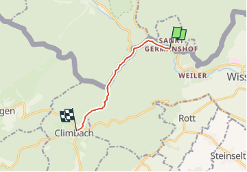
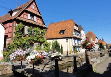
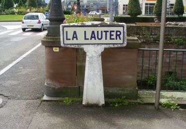
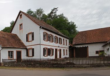
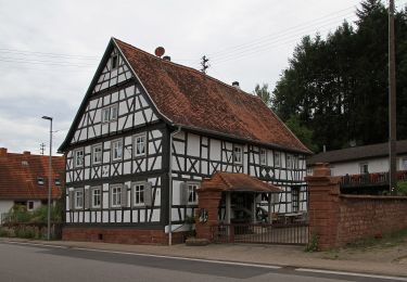
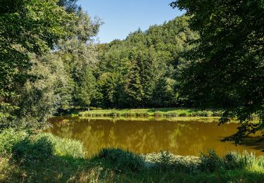
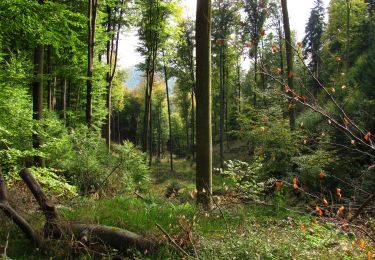
Randonnée A pied de 5,5 km à découvrir à Grand Est, Bas-Rhin, Wissembourg. Cette randonnée est proposée par SityTrail - itinéraires balisés pédestres.
Description
Randonnée créée par Club Vosgien.
Symbole: Green cross on white ground
Localisation
Pays :
France
Région :
Grand Est
Département/Province :
Bas-Rhin
Commune :
Wissembourg
Localité :
Unknown
Départ:(Dec)
Départ:(UTM)
419564 ; 5433099 (32U) N.
Commentaires
Randonnées à proximité
![Randonnée A pied Cleebourg - Disque jaune - Photo](https://media.geolcdn.com/t/375/260/e4476995-5782-472a-90f8-979658e5121c.jpeg&format=jpg&maxdim=2)
![A pied A pied](https://static1.geolcdn.com/sitytour/trail-icons/100.png)
![Randonnée A pied Wissembourg - Rotes Kreuz - Photo](https://media.geolcdn.com/t/375/260/68ad6046-667d-4bda-b0a1-354cff9d940f.jpeg&format=jpg&maxdim=2)
![A pied A pied](https://static1.geolcdn.com/sitytour/trail-icons/100.png)
Rotes Kreuz
A pied
Facile
Wissembourg,
Grand Est,
Bas-Rhin,
France
![](/images/other/stat-length.png)
6,5 km | 9,6 km-effort
2h 11min
![](https://static1.geolcdn.com/siteimages/upload/files/16400158638029165_repeat_loop_refresh_sync_direction_icon.png)
Non
![Randonnée A pied Wissembourg - Disque vert - Photo](https://media.geolcdn.com/t/375/260/99623353-36c3-423c-a751-656a0e168277.jpeg&format=jpg&maxdim=2)
![A pied A pied](https://static1.geolcdn.com/sitytour/trail-icons/100.png)
Disque vert
A pied
Facile
Wissembourg,
Grand Est,
Bas-Rhin,
France
![](/images/other/stat-length.png)
8,9 km | 12,9 km-effort
2h 56min
![](https://static1.geolcdn.com/siteimages/upload/files/16400158638029165_repeat_loop_refresh_sync_direction_icon.png)
Non
![Randonnée A pied Wissembourg - Anneau rouge - Photo](https://media.geolcdn.com/t/375/260/55a6a0a6-0f10-4437-aabb-c766882fbdd8.jpeg&format=jpg&maxdim=2)
![A pied A pied](https://static1.geolcdn.com/sitytour/trail-icons/100.png)
Anneau rouge
A pied
Facile
Wissembourg,
Grand Est,
Bas-Rhin,
France
![](/images/other/stat-length.png)
7,4 km | 9,6 km-effort
2h 11min
![](https://static1.geolcdn.com/siteimages/upload/files/16400158638029165_repeat_loop_refresh_sync_direction_icon.png)
Oui
![Randonnée A pied Wissembourg - Anneau vert - Photo](https://media.geolcdn.com/t/375/260/899751ba-5eaf-46ca-aeea-7f1e26b78d37.jpeg&format=jpg&maxdim=2)
![A pied A pied](https://static1.geolcdn.com/sitytour/trail-icons/100.png)
Anneau vert
A pied
Facile
Wissembourg,
Grand Est,
Bas-Rhin,
France
![](/images/other/stat-length.png)
13,5 km | 18,3 km-effort
4h 9min
![](https://static1.geolcdn.com/siteimages/upload/files/16400158638029165_repeat_loop_refresh_sync_direction_icon.png)
Oui
![Randonnée A pied Bobenthal - Hasenkopf-Runde - Photo](https://media.geolcdn.com/t/375/260/d8f83b19-46fe-4f0b-af1d-c304a05750ef.jpeg&format=jpg&maxdim=2)
![A pied A pied](https://static1.geolcdn.com/sitytour/trail-icons/100.png)
Hasenkopf-Runde
A pied
Facile
Bobenthal,
Rhénanie-Palatinat,
Südwestpfalz,
Allemagne
![](/images/other/stat-length.png)
7,9 km | 10,9 km-effort
2h 28min
![](https://static1.geolcdn.com/siteimages/upload/files/16400158638029165_repeat_loop_refresh_sync_direction_icon.png)
Non
![Randonnée A pied Bobenthal - Hirzeck-Gipfel-Steig - Photo](https://media.geolcdn.com/t/375/260/fff086e2-3060-4491-a9c2-5e848399b322.jpeg&format=jpg&maxdim=2)
![A pied A pied](https://static1.geolcdn.com/sitytour/trail-icons/100.png)
Hirzeck-Gipfel-Steig
A pied
Facile
Bobenthal,
Rhénanie-Palatinat,
Südwestpfalz,
Allemagne
![](/images/other/stat-length.png)
14,1 km | 19,3 km-effort
4h 22min
![](https://static1.geolcdn.com/siteimages/upload/files/16400158638029165_repeat_loop_refresh_sync_direction_icon.png)
Oui
![Randonnée A pied Schweigen-Rechtenbach - Rund ums Steinbühl Schweigen-Rechtenbach - Photo](https://media.geolcdn.com/t/375/260/918f5ff8-7ace-428c-9e42-3f204543353a.jpeg&format=jpg&maxdim=2)
![A pied A pied](https://static1.geolcdn.com/sitytour/trail-icons/100.png)
Rund ums Steinbühl Schweigen-Rechtenbach
A pied
Facile
Schweigen-Rechtenbach,
Rhénanie-Palatinat,
Landkreis Südliche Weinstraße,
Allemagne
![](/images/other/stat-length.png)
7,8 km | 11,1 km-effort
2h 31min
![](https://static1.geolcdn.com/siteimages/upload/files/16400158638029165_repeat_loop_refresh_sync_direction_icon.png)
Non
![Randonnée A pied Schweigen-Rechtenbach - Ruine Guttenberg Tour Schweigen-Rechtenbach - Photo](https://media.geolcdn.com/t/375/260/fffbdcab-7fb1-4aea-81a4-e93247296b54.jpeg&format=jpg&maxdim=2)
![A pied A pied](https://static1.geolcdn.com/sitytour/trail-icons/100.png)
Ruine Guttenberg Tour Schweigen-Rechtenbach
A pied
Facile
Schweigen-Rechtenbach,
Rhénanie-Palatinat,
Landkreis Südliche Weinstraße,
Allemagne
![](/images/other/stat-length.png)
10,2 km | 14,2 km-effort
3h 13min
![](https://static1.geolcdn.com/siteimages/upload/files/16400158638029165_repeat_loop_refresh_sync_direction_icon.png)
Oui