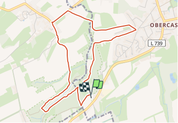
![](/images/other/stat-length.png)
![Randonnée A pied Castrop-Rauxel - Naturpfad Langeloh - Photo](https://media.geolcdn.com/t/1900/400/5f75bcad-d852-4220-bfb4-e4cc27c0945f.jpeg&format=pjpeg&maxdim=2)
Naturpfad Langeloh
SityTrail - itinéraires balisés pédestres
Tous les sentiers balisés d’Europe GUIDE+
![Longueur](/images/other/stat-length.png)
![Altitude max](https://static1.geolcdn.com/siteimages/upload/files/1508320355ic_sort_altitude_max_24dp.png)
![Dénivelé positif](https://static1.geolcdn.com/siteimages/upload/files/1508320355ic_sort_den_pos_24dp.png)
![Km-Effort](/images/other/stat-length.png)
![Altitude min](https://static1.geolcdn.com/siteimages/upload/files/1508320355ic_sort_altitude_min_24dp.png)
![Dénivelé négatif](https://static1.geolcdn.com/siteimages/upload/files/1508320355ic_sort_den_neg_24dp.png)
![Boucle](https://static1.geolcdn.com/siteimages/upload/files/16400158638029165_repeat_loop_refresh_sync_direction_icon.png)
![A pied](https://static1.geolcdn.com/sitytour/trail-icons/100.png)
1h17
Difficulté : Facile
![Scannez ce code QR pour ouvrir la randonnée dans l'application SityTrail](https://capi.geolives.com/qq0zvz2zws4bq2lad0pu/sitytour/trails/3088603/qr.png?size=200)
Application GPS de randonnée GRATUITE
À propos
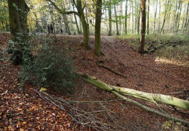
Randonnée A pied de 4,7 km à découvrir à Rhénanie-du-Nord-Westphalie, Kreis Recklinghausen, Castrop-Rauxel. Cette randonnée est proposée par SityTrail - itinéraires balisés pédestres.
Description
Randonnée créée par Regionalverband Ruhr.
Symbole: Gelbe Pfeile auf Holzpfosten, Wegstationen sind mit schwarzen Zahlen auf Holzpfosten markiert
Localisation
Commentaires
Randonnées à proximité
![Randonnée A pied Inconnu - Balken Grumme-Castrop - Photo](https://media.geolcdn.com/t/375/260/33b43d47-16b5-4564-924e-62097ffc0973.jpeg&format=jpg&maxdim=2)
![A pied A pied](https://static1.geolcdn.com/sitytour/trail-icons/100.png)
A pied
![](/images/other/stat-length.png)
![](https://static1.geolcdn.com/siteimages/upload/files/16400158638029165_repeat_loop_refresh_sync_direction_icon.png)
![Randonnée A pied Inconnu - Westerfilde Rundweg A1 - Photo](https://media.geolcdn.com/t/375/260/d46b428f-8027-445a-b8d5-0a3076261b54.jpeg&format=jpg&maxdim=2)
![A pied A pied](https://static1.geolcdn.com/sitytour/trail-icons/100.png)
A pied
![](/images/other/stat-length.png)
![](https://static1.geolcdn.com/siteimages/upload/files/16400158638029165_repeat_loop_refresh_sync_direction_icon.png)
![Randonnée A pied Inconnu - Westerfilde Rundweg A2 - Photo](https://media.geolcdn.com/t/375/260/d46b428f-8027-445a-b8d5-0a3076261b54.jpeg&format=jpg&maxdim=2)
![A pied A pied](https://static1.geolcdn.com/sitytour/trail-icons/100.png)
A pied
![](/images/other/stat-length.png)
![](https://static1.geolcdn.com/siteimages/upload/files/16400158638029165_repeat_loop_refresh_sync_direction_icon.png)
![Randonnée A pied Inconnu - Lütgendortmund Rundweg A3 - Photo](https://media.geolcdn.com/t/375/260/94efa19f-9034-49d4-ac68-23b935d7f8d3.jpeg&format=jpg&maxdim=2)
![A pied A pied](https://static1.geolcdn.com/sitytour/trail-icons/100.png)
A pied
![](/images/other/stat-length.png)
![](https://static1.geolcdn.com/siteimages/upload/files/16400158638029165_repeat_loop_refresh_sync_direction_icon.png)
![Randonnée A pied Inconnu - Lütgendortmund Rundweg A2 - Photo](https://media.geolcdn.com/t/375/260/74fcc15b-562e-46cd-bd7b-1babd48cb994.jpeg&format=jpg&maxdim=2)
![A pied A pied](https://static1.geolcdn.com/sitytour/trail-icons/100.png)
A pied
![](/images/other/stat-length.png)
![](https://static1.geolcdn.com/siteimages/upload/files/16400158638029165_repeat_loop_refresh_sync_direction_icon.png)
![Randonnée A pied Castrop-Rauxel - Grutholz Rundweg A1 - Photo](https://media.geolcdn.com/t/375/260/075acfab-20cc-4d2b-92ad-95cd4d50cfef.jpeg&format=jpg&maxdim=2)
![A pied A pied](https://static1.geolcdn.com/sitytour/trail-icons/100.png)
A pied
![](/images/other/stat-length.png)
![](https://static1.geolcdn.com/siteimages/upload/files/16400158638029165_repeat_loop_refresh_sync_direction_icon.png)
![Randonnée A pied - Gysenberg Rundweg A1 - Photo](https://media.geolcdn.com/t/375/260/a9cafc58-f261-4607-a234-7123937a0f8c.jpeg&format=jpg&maxdim=2)
![A pied A pied](https://static1.geolcdn.com/sitytour/trail-icons/100.png)
A pied
![](/images/other/stat-length.png)
![](https://static1.geolcdn.com/siteimages/upload/files/16400158638029165_repeat_loop_refresh_sync_direction_icon.png)
![Randonnée A pied - Gysenberg Rundweg A2 - Photo](https://media.geolcdn.com/t/375/260/329d2287-7657-4133-9a47-383d57037321.jpeg&format=jpg&maxdim=2)
![A pied A pied](https://static1.geolcdn.com/sitytour/trail-icons/100.png)
A pied
![](/images/other/stat-length.png)
![](https://static1.geolcdn.com/siteimages/upload/files/16400158638029165_repeat_loop_refresh_sync_direction_icon.png)
![Randonnée A pied - O Rundweg Gysenberg - Photo](https://media.geolcdn.com/t/375/260/57688ef2-f18d-4f66-bfa3-3a82013bec8c.jpeg&format=jpg&maxdim=2)
![A pied A pied](https://static1.geolcdn.com/sitytour/trail-icons/100.png)
A pied
![](/images/other/stat-length.png)
![](https://static1.geolcdn.com/siteimages/upload/files/16400158638029165_repeat_loop_refresh_sync_direction_icon.png)