![](/images/other/stat-length.png)
![Randonnée A pied Inconnu - European Long distance path E1 - part Germany, Hamburg (alternative route Boberger Düne) - Photo](https://media.geolcdn.com/t/1900/400/8f301112-3c3d-42a4-84ce-1989fa920474.jpeg&format=pjpeg&maxdim=2)
European Long distance path E1 - part Germany, Hamburg (alternative route Boberger Düne)
SityTrail - itinéraires balisés pédestres
Tous les sentiers balisés d’Europe GUIDE+
![Longueur](/images/other/stat-length.png)
Longueur
3,7 km
![Altitude max](https://static1.geolcdn.com/siteimages/upload/files/1508320355ic_sort_altitude_max_24dp.png)
Altitude max
30 m
![Dénivelé positif](https://static1.geolcdn.com/siteimages/upload/files/1508320355ic_sort_den_pos_24dp.png)
Dénivelé positif
30 m
![Km-Effort](/images/other/stat-length.png)
Km-Effort
4,1 km
![Altitude min](https://static1.geolcdn.com/siteimages/upload/files/1508320355ic_sort_altitude_min_24dp.png)
Altitude min
-1 m
![Dénivelé négatif](https://static1.geolcdn.com/siteimages/upload/files/1508320355ic_sort_den_neg_24dp.png)
Dénivelé négatif
38 m
![Boucle](https://static1.geolcdn.com/siteimages/upload/files/16400158638029165_repeat_loop_refresh_sync_direction_icon.png)
Boucle
Non
Balise
Date de création :
2022-02-11 12:54:08.659
Dernière modification :
2022-02-11 12:54:08.659
![A pied](https://static1.geolcdn.com/sitytour/trail-icons/100.png)
55m
Difficulté : Facile
![Scannez ce code QR pour ouvrir la randonnée dans l'application SityTrail](https://capi.geolives.com/qq0zvz2zws4bq2lad0pu/sitytour/trails/3088441/qr.png?size=200)
Application GPS de randonnée GRATUITE
À propos
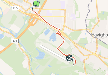
Randonnée A pied de 3,7 km à découvrir à Hambourg, Inconnu, Inconnu. Cette randonnée est proposée par SityTrail - itinéraires balisés pédestres.
Description
Randonnée créée par European Ramblers Association.
Wegmarkierung vollständig vorhanden
Symbole: Weißes Andreaskreuz auf schwarzem Grund
Site web: http://www.era-ewv-ferp.com/
Localisation
Pays :
Allemagne
Région :
Hambourg
Département/Province :
Inconnu
Commune :
Inconnu
Localité :
Hamburg-Mitte
Départ:(Dec)
Départ:(UTM)
574972 ; 5931780 (32U) N.
Commentaires
Randonnées à proximité
![Randonnée A pied Inconnu - Terassenweg [Boberger Niederung] - Photo](https://media.geolcdn.com/t/375/260/daa5b3e8-00da-475f-96fc-54c0669e58d3.jpeg&format=jpg&maxdim=2)
![A pied A pied](https://static1.geolcdn.com/sitytour/trail-icons/100.png)
Terassenweg [Boberger Niederung]
A pied
Facile
Inconnu,
Hambourg,
Inconnu,
Allemagne
![](/images/other/stat-length.png)
3,3 km | 3,8 km-effort
51min
![](https://static1.geolcdn.com/siteimages/upload/files/16400158638029165_repeat_loop_refresh_sync_direction_icon.png)
Oui
![Randonnée A pied Inconnu - Dünenweg [Boberger Niederung] - Photo](https://media.geolcdn.com/t/375/260/5f46b271-360d-4f90-b83a-6326a2aa90e5.jpeg&format=jpg&maxdim=2)
![A pied A pied](https://static1.geolcdn.com/sitytour/trail-icons/100.png)
Dünenweg [Boberger Niederung]
A pied
Facile
Inconnu,
Hambourg,
Inconnu,
Allemagne
![](/images/other/stat-length.png)
3,5 km | 3,7 km-effort
50min
![](https://static1.geolcdn.com/siteimages/upload/files/16400158638029165_repeat_loop_refresh_sync_direction_icon.png)
Oui
![Randonnée A pied Inconnu - Wiesenweg [Boberger Niederung] - Photo](https://media.geolcdn.com/t/375/260/ext.jpg?maxdim=2&url=https%3A%2F%2Fstatic1.geolcdn.com%2Fsiteimages%2Fupload%2Ffiles%2F1545311037marcheuse_200dpi.jpg)
![A pied A pied](https://static1.geolcdn.com/sitytour/trail-icons/100.png)
Wiesenweg [Boberger Niederung]
A pied
Facile
Inconnu,
Hambourg,
Inconnu,
Allemagne
![](/images/other/stat-length.png)
4,3 km | 4,5 km-effort
1h 1min
![](https://static1.geolcdn.com/siteimages/upload/files/16400158638029165_repeat_loop_refresh_sync_direction_icon.png)
Oui