![](/images/other/stat-length.png)
![Randonnée A pied Glinde - Glinde - Ahrensburg (GL-AH) - Photo](https://media.geolcdn.com/t/1900/400/ext.pjpeg?maxdim=2&url=https%3A%2F%2Fstatic1.geolcdn.com%2Fsiteimages%2Fupload%2Ffiles%2F1545311037marcheuse_200dpi.jpg)
Glinde - Ahrensburg (GL-AH)
SityTrail - itinéraires balisés pédestres
Tous les sentiers balisés d’Europe GUIDE+
![Longueur](/images/other/stat-length.png)
Longueur
22 km
![Altitude max](https://static1.geolcdn.com/siteimages/upload/files/1508320355ic_sort_altitude_max_24dp.png)
Altitude max
68 m
![Dénivelé positif](https://static1.geolcdn.com/siteimages/upload/files/1508320355ic_sort_den_pos_24dp.png)
Dénivelé positif
152 m
![Km-Effort](/images/other/stat-length.png)
Km-Effort
24 km
![Altitude min](https://static1.geolcdn.com/siteimages/upload/files/1508320355ic_sort_altitude_min_24dp.png)
Altitude min
23 m
![Dénivelé négatif](https://static1.geolcdn.com/siteimages/upload/files/1508320355ic_sort_den_neg_24dp.png)
Dénivelé négatif
119 m
![Boucle](https://static1.geolcdn.com/siteimages/upload/files/16400158638029165_repeat_loop_refresh_sync_direction_icon.png)
Boucle
Non
Balise
Date de création :
2022-02-11 12:53:21.234
Dernière modification :
2022-02-11 12:53:21.234
![A pied](https://static1.geolcdn.com/sitytour/trail-icons/100.png)
5h24
Difficulté : Moyen
![Scannez ce code QR pour ouvrir la randonnée dans l'application SityTrail](https://capi.geolives.com/qq0zvz2zws4bq2lad0pu/sitytour/trails/3088366/qr.png?size=200)
Application GPS de randonnée GRATUITE
À propos
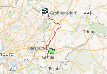
Randonnée A pied de 22 km à découvrir à Schleswig-Holstein, Stormarn, Glinde. Cette randonnée est proposée par SityTrail - itinéraires balisés pédestres.
Description
Randonnée créée par Wanderverband Norddeutschland; Wanderfreunde Stormann.
Symbole: gelber Pfeil auf weißem Grund
Localisation
Pays :
Allemagne
Région :
Schleswig-Holstein
Département/Province :
Stormarn
Commune :
Glinde
Localité :
Unknown
Départ:(Dec)
Départ:(UTM)
580276 ; 5933037 (32U) N.
Commentaires
Randonnées à proximité
![Randonnée A pied Reinbek - Aumühle - Großensee (AU-GS) - Photo](https://media.geolcdn.com/t/375/260/c9f0754e-4e2a-46ff-87e7-63f191af1a35.jpeg&format=jpg&maxdim=2)
![A pied A pied](https://static1.geolcdn.com/sitytour/trail-icons/100.png)
Aumühle - Großensee (AU-GS)
A pied
Facile
Reinbek,
Schleswig-Holstein,
Stormarn,
Allemagne
![](/images/other/stat-length.png)
3,3 km | 3,8 km-effort
51min
![](https://static1.geolcdn.com/siteimages/upload/files/16400158638029165_repeat_loop_refresh_sync_direction_icon.png)
Non
![Randonnée A pied Inconnu - Terassenweg [Boberger Niederung] - Photo](https://media.geolcdn.com/t/375/260/daa5b3e8-00da-475f-96fc-54c0669e58d3.jpeg&format=jpg&maxdim=2)
![A pied A pied](https://static1.geolcdn.com/sitytour/trail-icons/100.png)
Terassenweg [Boberger Niederung]
A pied
Facile
Inconnu,
Hambourg,
Inconnu,
Allemagne
![](/images/other/stat-length.png)
3,3 km | 3,8 km-effort
51min
![](https://static1.geolcdn.com/siteimages/upload/files/16400158638029165_repeat_loop_refresh_sync_direction_icon.png)
Oui
![Randonnée A pied Inconnu - Dünenweg [Boberger Niederung] - Photo](https://media.geolcdn.com/t/375/260/5f46b271-360d-4f90-b83a-6326a2aa90e5.jpeg&format=jpg&maxdim=2)
![A pied A pied](https://static1.geolcdn.com/sitytour/trail-icons/100.png)
Dünenweg [Boberger Niederung]
A pied
Facile
Inconnu,
Hambourg,
Inconnu,
Allemagne
![](/images/other/stat-length.png)
3,5 km | 3,7 km-effort
50min
![](https://static1.geolcdn.com/siteimages/upload/files/16400158638029165_repeat_loop_refresh_sync_direction_icon.png)
Oui
![Randonnée A pied Reinbek - Walderlebnispfad Staatsforst Trittau - Photo](https://media.geolcdn.com/t/375/260/c9bff8b4-7241-4ef3-b111-0358245c9da1.jpeg&format=jpg&maxdim=2)
![A pied A pied](https://static1.geolcdn.com/sitytour/trail-icons/100.png)
Walderlebnispfad Staatsforst Trittau
A pied
Facile
Reinbek,
Schleswig-Holstein,
Stormarn,
Allemagne
![](/images/other/stat-length.png)
3 km | 3,5 km-effort
47min
![](https://static1.geolcdn.com/siteimages/upload/files/16400158638029165_repeat_loop_refresh_sync_direction_icon.png)
Oui
![Randonnée A pied Glinde - Glinde - Ahrensburg (GL-AH) Gesamt - Photo](https://media.geolcdn.com/t/375/260/ext.jpg?maxdim=2&url=https%3A%2F%2Fstatic1.geolcdn.com%2Fsiteimages%2Fupload%2Ffiles%2F1545311037marcheuse_200dpi.jpg)
![A pied A pied](https://static1.geolcdn.com/sitytour/trail-icons/100.png)
Glinde - Ahrensburg (GL-AH) Gesamt
A pied
Moyen
Glinde,
Schleswig-Holstein,
Stormarn,
Allemagne
![](/images/other/stat-length.png)
22 km | 24 km-effort
5h 24min
![](https://static1.geolcdn.com/siteimages/upload/files/16400158638029165_repeat_loop_refresh_sync_direction_icon.png)
Non