Randonnée A pied Inconnu - Bittermark Rundweg A1 - Photo

Tous les sentiers balisés d’Europe GUIDE+

© OpenStreetMap contributors
Longueur
Longueur
4,7 km
Altitude max
Altitude max
256 m
Dénivelé positif
Dénivelé positif
132 m
Km-Effort
Km-Effort  
6,2 km
Altitude min
Altitude min
131 m
Dénivelé négatif
Dénivelé négatif
60 m
Boucle
Boucle
Non
Balise
Balise
Date de création :
2022-02-11 12:52:14.593
Dernière modification :
2022-02-11 12:52:14.593

(0 Avis)

A pied
A pied
1h24
Difficulté : Facile

Scannez ce code QR pour ouvrir la randonnée dans l'application SityTrail

Application GPS de randonnée GRATUITE

Logo SityTrail SityTrail

IGN / Instituts géographiques

Télécharger SityTrail sur l'App Store Télécharger SityTrail sur Google Play

Logo SityTrail SityTrail World

Le monde est à vous

Télécharger SityTrail sur l'App Store Télécharger SityTrail sur Google Play Télécharger SityTrail sur Huawei AppGallery

À propos

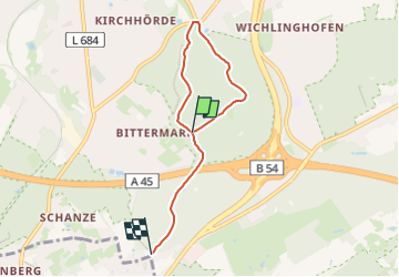
Randonnée A pied de 4,7 km à découvrir à Rhénanie-du-Nord-Westphalie, Dortmund, Inconnu. Cette randonnée est proposée par SityTrail - itinéraires balisés pédestres.

Description

Randonnée créée par Sauerländischer Gebirgsverein Bezirk Dortmund Ardey.

Symbole: weißes A1 auf schwarzem Grund

Profil altimétrique

Photos

Localisation

Pays :
Allemagne
Région :
Rhénanie-du-Nord-Westphalie
Département/Province :
Dortmund
Commune :
Inconnu
Localité :
Hombruch
Départ:(UTM)
393896 ; 5700585 (32U) N.

Randonnées à proximité

Randonnée A pied Herdecke - [H3] Hengsteysee und Teufelskanzel - Photo
A pied
GUIDE+

A pied

Facile
Herdecke, Rhénanie-du-Nord-Westphalie, Ennepe-Ruhr-Kreis, Allemagne
6,7 km | 9,1 km-effort
2h 3min
Non
Randonnée A pied Inconnu - Dortmund-Mittelhöchsten Rundweg A3 - Photo
A pied
GUIDE+

A pied

Facile
Inconnu, Rhénanie-du-Nord-Westphalie, Dortmund, Allemagne
3,6 km | 4,6 km-effort
1h 3min
Oui
Randonnée A pied Inconnu - Dortmund-Mittelhöchsten Rundweg A2 - Photo
A pied
GUIDE+

A pied

Facile
Inconnu, Rhénanie-du-Nord-Westphalie, Dortmund, Allemagne
3,1 km | 3,9 km-effort
52min
Oui
Randonnée A pied Inconnu - Dortmund-Mittelhöchsten Rundweg A1 - Photo
A pied
GUIDE+

A pied

Facile
Inconnu, Rhénanie-du-Nord-Westphalie, Dortmund, Allemagne
3,5 km | 4,5 km-effort
1h 1min
Oui
Randonnée A pied Herdecke - Hickenstein Rundweg A4 - Photo
A pied
GUIDE+

A pied

Facile
Herdecke, Rhénanie-du-Nord-Westphalie, Ennepe-Ruhr-Kreis, Allemagne
6,7 km | 8,9 km-effort
2h 1min
Oui
Randonnée A pied Inconnu - Löttringhausen Rundweg A4 - Photo
A pied
GUIDE+

A pied

Facile
Inconnu, Rhénanie-du-Nord-Westphalie, Dortmund, Allemagne
8,2 km | 10,9 km-effort
2h 28min
Oui
Randonnée A pied Inconnu - [S1] Um den Syberg - Photo
A pied
GUIDE+

A pied

Facile
Inconnu, Rhénanie-du-Nord-Westphalie, Dortmund, Allemagne
4,3 km | 6,6 km-effort
1h 29min
Oui
Randonnée A pied Inconnu - Sechs Profile, ein Gesicht - Photo
A pied
GUIDE+

A pied

Facile
Inconnu, Rhénanie-du-Nord-Westphalie, Dortmund, Allemagne
4,7 km | 6,2 km-effort
1h 24min
Non
Randonnée A pied Inconnu - [S3] Klusenbergrundweg - Photo
A pied
GUIDE+

A pied

Facile
Inconnu, Rhénanie-du-Nord-Westphalie, Dortmund, Allemagne
5,6 km | 7,9 km-effort
1h 47min
Oui


Fermer
Mes abonnements