![](/images/other/stat-length.png)
![Randonnée A pied Gernsbach - Rundweg Nr. 1 - Grünhütten-Rundweg - Photo](https://media.geolcdn.com/t/1900/400/7fcc4a4c-c1cf-45e1-a893-e8b90459f9e9.jpeg&format=pjpeg&maxdim=2)
Rundweg Nr. 1 - Grünhütten-Rundweg
SityTrail - itinéraires balisés pédestres
Tous les sentiers balisés d’Europe GUIDE+
![Longueur](/images/other/stat-length.png)
![Altitude max](https://static1.geolcdn.com/siteimages/upload/files/1508320355ic_sort_altitude_max_24dp.png)
![Dénivelé positif](https://static1.geolcdn.com/siteimages/upload/files/1508320355ic_sort_den_pos_24dp.png)
![Km-Effort](/images/other/stat-length.png)
![Altitude min](https://static1.geolcdn.com/siteimages/upload/files/1508320355ic_sort_altitude_min_24dp.png)
![Dénivelé négatif](https://static1.geolcdn.com/siteimages/upload/files/1508320355ic_sort_den_neg_24dp.png)
![Boucle](https://static1.geolcdn.com/siteimages/upload/files/16400158638029165_repeat_loop_refresh_sync_direction_icon.png)
![A pied](https://static1.geolcdn.com/sitytour/trail-icons/100.png)
2h15
Difficulté : Facile
![Scannez ce code QR pour ouvrir la randonnée dans l'application SityTrail](https://capi.geolives.com/qq0zvz2zws4bq2lad0pu/sitytour/trails/3088123/qr.png?size=200)
Application GPS de randonnée GRATUITE
À propos
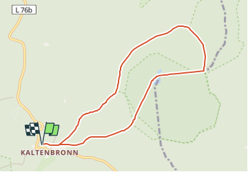
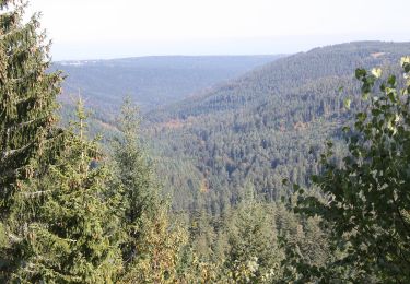
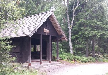
Randonnée A pied de 8,3 km à découvrir à Bade-Wurtemberg, Landkreis Rastatt, Gernsbach. Cette randonnée est proposée par SityTrail - itinéraires balisés pédestres.
Description
Randonnée créée par Infozentrum Kaltenbronn.
Symbole: Weißes Quadrat, mit dünner lila Linie umrahmt. Große schwarze 1 in der Mitte, darüber klein "Rundweg", darunter "Kaltenbronn"
Localisation
Commentaires
Randonnées à proximité
![Randonnée A pied Gernsbach - Orgelfelsenhaus-Teufelsmühle - Photo](https://media.geolcdn.com/t/375/260/e9d5d20a-a27c-4330-84a4-dc94b22c0093.jpeg&format=jpg&maxdim=2)
![A pied A pied](https://static1.geolcdn.com/sitytour/trail-icons/100.png)
A pied
![](/images/other/stat-length.png)
![](https://static1.geolcdn.com/siteimages/upload/files/16400158638029165_repeat_loop_refresh_sync_direction_icon.png)
![Randonnée A pied Enzklösterle - Enzklösterle-Gompelscheuer Flößerhaus - Photo](https://media.geolcdn.com/t/375/260/d60f591b-c3af-4633-967f-ac9f94433455.jpeg&format=jpg&maxdim=2)
![A pied A pied](https://static1.geolcdn.com/sitytour/trail-icons/100.png)
A pied
![](/images/other/stat-length.png)
![](https://static1.geolcdn.com/siteimages/upload/files/16400158638029165_repeat_loop_refresh_sync_direction_icon.png)
![Randonnée A pied Enzklösterle - Enzklösterle - Zwerenberg - Photo](https://media.geolcdn.com/t/375/260/d60f591b-c3af-4633-967f-ac9f94433455.jpeg&format=jpg&maxdim=2)
![A pied A pied](https://static1.geolcdn.com/sitytour/trail-icons/100.png)
A pied
![](/images/other/stat-length.png)
![](https://static1.geolcdn.com/siteimages/upload/files/16400158638029165_repeat_loop_refresh_sync_direction_icon.png)
![Randonnée A pied Gernsbach - Naturerlebnisweg Kaltenbronn - Photo](https://media.geolcdn.com/t/375/260/5abeb0a5-14eb-4923-a9ca-7d878e1f579c.jpeg&format=jpg&maxdim=2)
![A pied A pied](https://static1.geolcdn.com/sitytour/trail-icons/100.png)
A pied
![](/images/other/stat-length.png)
![](https://static1.geolcdn.com/siteimages/upload/files/16400158638029165_repeat_loop_refresh_sync_direction_icon.png)
![Randonnée Autre activité Gernsbach - Kaltenbronn - Wilde - Gruenhuette - Photo](https://media.geolcdn.com/t/375/260/ext.jpg?maxdim=2&url=https%3A%2F%2Fservices.sitytrail.com%2FGeolivesWS%2FDownloadMedia.ashx%3FTrailID%3D613348%26Media%3Dfix__20160812124451.jpg)
![Autre activité Autre activité](https://static1.geolcdn.com/sitytour/trail-icons/900.png)
Autre activité
![](/images/other/stat-length.png)
![](https://static1.geolcdn.com/siteimages/upload/files/16400158638029165_repeat_loop_refresh_sync_direction_icon.png)