


3,7 km | 4,1 km-effort
![Randonnée A pied Inconnu - Terassenweg [Boberger Niederung] - Photo](https://media.geolcdn.com/t/1900/400/daa5b3e8-00da-475f-96fc-54c0669e58d3.jpeg&format=pjpeg&maxdim=2)

Tous les sentiers balisés d’Europe GUIDE+


Application GPS de randonnée GRATUITE
 SityTrail
IGN / Instituts géographiques
SityTrail World
Le monde est à vous
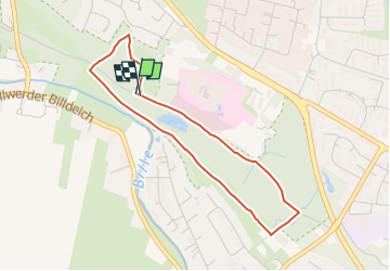
Randonnée A pied de 3,3 km à découvrir à Hambourg, Inconnu, Inconnu. Cette randonnée est proposée par SityTrail - itinéraires balisés pédestres.
Randonnée créée par Naturschutzverband GÖP.
Symbole: rote Blume auf weißem Grund
![Randonnée A pied Inconnu - Terassenweg [Boberger Niederung] - Photo 1](https://media.geolcdn.com/t/2048/auto/c59a3ae0-dfe4-4e81-897f-48d470b8e12a.jpeg&format=jpg&maxdim=0 "Randonnée A pied Inconnu - Terassenweg [Boberger Niederung] - Photo 1")
![Randonnée A pied Inconnu - Terassenweg [Boberger Niederung] - Photo 2](https://media.geolcdn.com/t/2048/auto/d34e3801-79be-4c31-893b-e5c74dcb656e.jpeg&format=jpg&maxdim=0 "Randonnée A pied Inconnu - Terassenweg [Boberger Niederung] - Photo 2")
![Randonnée A pied Inconnu - Terassenweg [Boberger Niederung] - Photo 3](https://media.geolcdn.com/t/2048/auto/0e13c2e4-e264-47bc-9915-d7e079368c3b.jpeg&format=jpg&maxdim=0 "Randonnée A pied Inconnu - Terassenweg [Boberger Niederung] - Photo 3")
![Randonnée A pied Inconnu - Terassenweg [Boberger Niederung] - Photo 4](https://media.geolcdn.com/t/2048/auto/9a6be569-3c36-4c78-ba24-35f442c4736d.jpeg&format=jpg&maxdim=0 "Randonnée A pied Inconnu - Terassenweg [Boberger Niederung] - Photo 4")
![Randonnée A pied Inconnu - Terassenweg [Boberger Niederung] - Photo 5](https://media.geolcdn.com/t/2048/auto/dfa1af24-9e2f-4a81-9e46-17280eabfee3.jpeg&format=jpg&maxdim=0 "Randonnée A pied Inconnu - Terassenweg [Boberger Niederung] - Photo 5")
![Randonnée A pied Inconnu - Terassenweg [Boberger Niederung] - Photo 6](https://media.geolcdn.com/t/2048/auto/51d3c6c8-4e22-4455-bec8-d64c4d3a2691.jpeg&format=jpg&maxdim=0 "Randonnée A pied Inconnu - Terassenweg [Boberger Niederung] - Photo 6")
![Randonnée A pied Inconnu - Terassenweg [Boberger Niederung] - Photo 7](https://media.geolcdn.com/t/2048/auto/4fc7738c-76a4-46da-9a57-d7bffdded57f.jpeg&format=jpg&maxdim=0 "Randonnée A pied Inconnu - Terassenweg [Boberger Niederung] - Photo 7")
![Randonnée A pied Inconnu - Terassenweg [Boberger Niederung] - Photo 8](https://media.geolcdn.com/t/2048/auto/8f52f83e-38f1-4452-964d-02f10ef3a7b9.jpeg&format=jpg&maxdim=0 "Randonnée A pied Inconnu - Terassenweg [Boberger Niederung] - Photo 8")
![Randonnée A pied Inconnu - Terassenweg [Boberger Niederung] - Photo 9](https://media.geolcdn.com/t/2048/auto/04ab4cca-0845-4e3b-8c9c-742b6445af05.jpeg&format=jpg&maxdim=0 "Randonnée A pied Inconnu - Terassenweg [Boberger Niederung] - Photo 9")
![Randonnée A pied Inconnu - Terassenweg [Boberger Niederung] - Photo 10](https://media.geolcdn.com/t/2048/auto/daa5b3e8-00da-475f-96fc-54c0669e58d3.jpeg&format=jpg&maxdim=0 "Randonnée A pied Inconnu - Terassenweg [Boberger Niederung] - Photo 10")
A pied
A pied
A pied
![Randonnée A pied Inconnu - Dünenweg [Boberger Niederung] - Photo](https://media.geolcdn.com/t/375/260/5f46b271-360d-4f90-b83a-6326a2aa90e5.jpeg&format=jpg&maxdim=2)
A pied
![Randonnée A pied Inconnu - Wiesenweg [Boberger Niederung] - Photo](https://media.geolcdn.com/t/375/260/ext.jpg?maxdim=2&url=https%3A%2F%2Fstatic1.geolcdn.com%2Fsiteimages%2Fupload%2Ffiles%2F1545311037marcheuse_200dpi.jpg)
A pied
A pied
A pied