![](/images/other/stat-length.png)
![Randonnée A pied Nittenau - Tour 2 »Weihertour« - Photo](https://media.geolcdn.com/t/1900/400/82c6bac3-13b2-423e-8be9-687a1b5300a6.jpeg&format=pjpeg&maxdim=2)
Tour 2 »Weihertour«
SityTrail - itinéraires balisés pédestres
Tous les sentiers balisés d’Europe GUIDE+
![Longueur](/images/other/stat-length.png)
![Altitude max](https://static1.geolcdn.com/siteimages/upload/files/1508320355ic_sort_altitude_max_24dp.png)
![Dénivelé positif](https://static1.geolcdn.com/siteimages/upload/files/1508320355ic_sort_den_pos_24dp.png)
![Km-Effort](/images/other/stat-length.png)
![Altitude min](https://static1.geolcdn.com/siteimages/upload/files/1508320355ic_sort_altitude_min_24dp.png)
![Dénivelé négatif](https://static1.geolcdn.com/siteimages/upload/files/1508320355ic_sort_den_neg_24dp.png)
![Boucle](https://static1.geolcdn.com/siteimages/upload/files/16400158638029165_repeat_loop_refresh_sync_direction_icon.png)
![A pied](https://static1.geolcdn.com/sitytour/trail-icons/100.png)
2h38
Difficulté : Facile
![Scannez ce code QR pour ouvrir la randonnée dans l'application SityTrail](https://capi.geolives.com/qq0zvz2zws4bq2lad0pu/sitytour/trails/3087984/qr.png?size=200)
Application GPS de randonnée GRATUITE
À propos
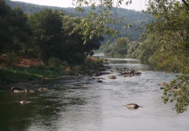
Randonnée A pied de 9,3 km à découvrir à Bavière, Landkreis Schwandorf, Nittenau. Cette randonnée est proposée par SityTrail - itinéraires balisés pédestres.
Description
Randonnée créée par Stadt Nittenau?.
FIXME: Nicht alle Segmente erfaßt.
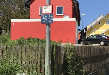
Symbole: Weiße oder schwarze Wegnummer in einem orangefarbenen, quadratischen Rahmen
Localisation
Commentaires
Randonnées à proximité
![Randonnée A pied Regenstauf - Tour 9 »Flusswanderung« - Photo](https://media.geolcdn.com/t/375/260/82c6bac3-13b2-423e-8be9-687a1b5300a6.jpeg&format=jpg&maxdim=2)
![A pied A pied](https://static1.geolcdn.com/sitytour/trail-icons/100.png)
A pied
![](/images/other/stat-length.png)
![](https://static1.geolcdn.com/siteimages/upload/files/16400158638029165_repeat_loop_refresh_sync_direction_icon.png)
![Randonnée A pied Nittenau - Wilder Mann 009 »Regentalwanderweg«, Naturpark Vorderer Bayerischer Wald - Photo](https://media.geolcdn.com/t/375/260/1c5de2b3-781f-493a-8e5f-c504ed68cfc5.jpeg&format=jpg&maxdim=2)
![A pied A pied](https://static1.geolcdn.com/sitytour/trail-icons/100.png)
A pied
![](/images/other/stat-length.png)
![](https://static1.geolcdn.com/siteimages/upload/files/16400158638029165_repeat_loop_refresh_sync_direction_icon.png)
![Randonnée A pied Regenstauf - Tour 6 »Schwarzbergtour« - Photo](https://media.geolcdn.com/t/375/260/82c6bac3-13b2-423e-8be9-687a1b5300a6.jpeg&format=jpg&maxdim=2)
![A pied A pied](https://static1.geolcdn.com/sitytour/trail-icons/100.png)
A pied
![](/images/other/stat-length.png)
![](https://static1.geolcdn.com/siteimages/upload/files/16400158638029165_repeat_loop_refresh_sync_direction_icon.png)
![Randonnée A pied Maxhütte-Haidhof - Regentalsteig nach Hirschling (Gelbe 8) - Photo](https://media.geolcdn.com/t/375/260/b11983bc-bc26-43bd-9762-2dddd756d7eb.jpeg&format=jpg&maxdim=2)
![A pied A pied](https://static1.geolcdn.com/sitytour/trail-icons/100.png)
A pied
![](/images/other/stat-length.png)
![](https://static1.geolcdn.com/siteimages/upload/files/16400158638029165_repeat_loop_refresh_sync_direction_icon.png)
![Randonnée A pied Regenstauf - Wilder Mann 005, Naturpark Vorderer Bayerischer Wald - Photo](https://media.geolcdn.com/t/375/260/82c6bac3-13b2-423e-8be9-687a1b5300a6.jpeg&format=jpg&maxdim=2)
![A pied A pied](https://static1.geolcdn.com/sitytour/trail-icons/100.png)
A pied
![](/images/other/stat-length.png)
![](https://static1.geolcdn.com/siteimages/upload/files/16400158638029165_repeat_loop_refresh_sync_direction_icon.png)
![Randonnée A pied Nittenau - Wanderwege rund um Nittenau - 01 - Wasserstein - Photo](https://media.geolcdn.com/t/375/260/c6556976-d120-4c26-ac90-4c44d35627fa.jpeg&format=jpg&maxdim=2)
![A pied A pied](https://static1.geolcdn.com/sitytour/trail-icons/100.png)
A pied
![](/images/other/stat-length.png)
![](https://static1.geolcdn.com/siteimages/upload/files/16400158638029165_repeat_loop_refresh_sync_direction_icon.png)
![Randonnée A pied Regenstauf - Wanderwege rund um Nittenau - 02 - Wackelstein - Photo](https://media.geolcdn.com/t/375/260/82c6bac3-13b2-423e-8be9-687a1b5300a6.jpeg&format=jpg&maxdim=2)
![A pied A pied](https://static1.geolcdn.com/sitytour/trail-icons/100.png)
A pied
![](/images/other/stat-length.png)
![](https://static1.geolcdn.com/siteimages/upload/files/16400158638029165_repeat_loop_refresh_sync_direction_icon.png)
![Randonnée A pied Nittenau - Drei-Burgen-Weg (Nittenau) - Photo](https://media.geolcdn.com/t/375/260/1cabed54-af42-41ae-b0b5-002009ace729.jpeg&format=jpg&maxdim=2)
![A pied A pied](https://static1.geolcdn.com/sitytour/trail-icons/100.png)
A pied
![](/images/other/stat-length.png)
![](https://static1.geolcdn.com/siteimages/upload/files/16400158638029165_repeat_loop_refresh_sync_direction_icon.png)
![Randonnée A pied Nittenau - Wilder Mann 011, Naturpark Vorderer Bayerischer Wald - Photo](https://media.geolcdn.com/t/375/260/ae168eb1-17f7-4deb-8741-30aba347f873.jpeg&format=jpg&maxdim=2)
![A pied A pied](https://static1.geolcdn.com/sitytour/trail-icons/100.png)
A pied
![](/images/other/stat-length.png)
![](https://static1.geolcdn.com/siteimages/upload/files/16400158638029165_repeat_loop_refresh_sync_direction_icon.png)