![](/images/other/stat-length.png)
![Randonnée Marche La Seyne-sur-Mer - Forêt de Janas rando 9 02 - Photo](https://media.geolcdn.com/t/1900/400/f9755704-4947-49ba-85f8-5f013d2115ad.jpg&format=pjpeg&maxdim=2)
Forêt de Janas rando 9 02
sonneville
Utilisateur
![Longueur](/images/other/stat-length.png)
Longueur
15,8 km
![Altitude max](https://static1.geolcdn.com/siteimages/upload/files/1508320355ic_sort_altitude_max_24dp.png)
Altitude max
183 m
![Dénivelé positif](https://static1.geolcdn.com/siteimages/upload/files/1508320355ic_sort_den_pos_24dp.png)
Dénivelé positif
438 m
![Km-Effort](/images/other/stat-length.png)
Km-Effort
22 km
![Altitude min](https://static1.geolcdn.com/siteimages/upload/files/1508320355ic_sort_altitude_min_24dp.png)
Altitude min
5 m
![Dénivelé négatif](https://static1.geolcdn.com/siteimages/upload/files/1508320355ic_sort_den_neg_24dp.png)
Dénivelé négatif
431 m
![Boucle](https://static1.geolcdn.com/siteimages/upload/files/16400158638029165_repeat_loop_refresh_sync_direction_icon.png)
Boucle
Oui
Date de création :
2022-02-10 09:05:47.048
Dernière modification :
2023-01-15 16:54:26.461
![Marche](https://static1.geolcdn.com/sitytour/trail-icons/101.png)
6h04
Difficulté : Très difficile
![Scannez ce code QR pour ouvrir la randonnée dans l'application SityTrail](https://capi.geolives.com/qq0zvz2zws4bq2lad0pu/sitytour/trails/3086512/qr.png?size=200)
Application GPS de randonnée GRATUITE
À propos
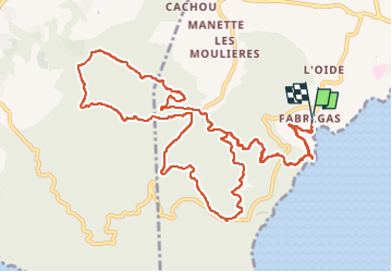
Randonnée Marche de 15,8 km à découvrir à Provence-Alpes-Côte d'Azur, Var, La Seyne-sur-Mer. Cette randonnée est proposée par sonneville.
Description
Départ de Fabrégas, sentier littoral, parcours sportif, tour de Francillon, retour sur parcours sportif, direction batterie de Peyras
Localisation
Pays :
France
Région :
Provence-Alpes-Côte d'Azur
Département/Province :
Var
Commune :
La Seyne-sur-Mer
Localité :
Unknown
Départ:(Dec)
Départ:(UTM)
733777 ; 4772581 (31T) N.
Commentaires
Randonnées à proximité
![Randonnée Marche Six-Fours-les-Plages - ND de Pepiole via colline du fort de Six-Fours, retour par Les Lônes - Photo](https://media.geolcdn.com/t/375/260/1379151f-75a9-4587-8d69-64d0542e06ca.jpg&format=jpg&maxdim=2)
![Marche Marche](https://static1.geolcdn.com/sitytour/trail-icons/101.png)
ND de Pepiole via colline du fort de Six-Fours, retour par Les Lônes
Marche
Facile
(1)
Six-Fours-les-Plages,
Provence-Alpes-Côte d'Azur,
Var,
France
![](/images/other/stat-length.png)
8,2 km | 10,7 km-effort
3h 0min
![](https://static1.geolcdn.com/siteimages/upload/files/16400158638029165_repeat_loop_refresh_sync_direction_icon.png)
Oui
![Randonnée Marche Six-Fours-les-Plages - ND de Pepiole via colline du fort de Six-Fours - Photo](https://media.geolcdn.com/t/375/260/1379151f-75a9-4587-8d69-64d0542e06ca.jpg&format=jpg&maxdim=2)
![Marche Marche](https://static1.geolcdn.com/sitytour/trail-icons/101.png)
ND de Pepiole via colline du fort de Six-Fours
Marche
Facile
(1)
Six-Fours-les-Plages,
Provence-Alpes-Côte d'Azur,
Var,
France
![](/images/other/stat-length.png)
8,7 km | 12,3 km-effort
3h 0min
![](https://static1.geolcdn.com/siteimages/upload/files/16400158638029165_repeat_loop_refresh_sync_direction_icon.png)
Oui
![Randonnée Marche La Seyne-sur-Mer - fabregas parking du bœuf, plage des nudistes, sémaphore, notre dame de mai. - Photo](https://media.geolcdn.com/t/375/260/d2496b6d-773d-4991-9a61-fe4c8adf1522.jpg&format=jpg&maxdim=2)
![Marche Marche](https://static1.geolcdn.com/sitytour/trail-icons/101.png)
fabregas parking du bœuf, plage des nudistes, sémaphore, notre dame de mai.
Marche
Moyen
(3)
La Seyne-sur-Mer,
Provence-Alpes-Côte d'Azur,
Var,
France
![](/images/other/stat-length.png)
10,2 km | 16,3 km-effort
2h 52min
![](https://static1.geolcdn.com/siteimages/upload/files/16400158638029165_repeat_loop_refresh_sync_direction_icon.png)
Oui
![Randonnée V.T.T. La Seyne-sur-Mer - Cap Sicié - Fabregas - Photo](https://media.geolcdn.com/t/375/260/ext.jpg?maxdim=2&url=https%3A%2F%2Fservices.sitytrail.com%2FGeolivesWS%2FDownloadMedia.ashx%3FTrailID%3D105841%26Media%3D9806_1.jpg)
![V.T.T. V.T.T.](https://static1.geolcdn.com/sitytour/trail-icons/202.png)
Cap Sicié - Fabregas
V.T.T.
Difficile
(3)
La Seyne-sur-Mer,
Provence-Alpes-Côte d'Azur,
Var,
France
![](/images/other/stat-length.png)
18,3 km | 26 km-effort
2h 40min
![](https://static1.geolcdn.com/siteimages/upload/files/16400158638029165_repeat_loop_refresh_sync_direction_icon.png)
Oui
![Randonnée Marche Toulon - Tour royale à Monaco 13 Novembre 2021 - Photo](https://media.geolcdn.com/t/375/260/d44cd298-c3f2-4c69-9481-e73635990ceb.jpg&format=jpg&maxdim=2)
![Marche Marche](https://static1.geolcdn.com/sitytour/trail-icons/101.png)
Tour royale à Monaco 13 Novembre 2021
Marche
Facile
Toulon,
Provence-Alpes-Côte d'Azur,
Var,
France
![](/images/other/stat-length.png)
15,6 km | 19,8 km-effort
5h 49min
![](https://static1.geolcdn.com/siteimages/upload/files/16400158638029165_repeat_loop_refresh_sync_direction_icon.png)
Non
![Randonnée Marche Six-Fours-les-Plages - Graffitis - blockhaus - Crètes du Quicon - Dolmen de La Lèque - Roumagnan - Photo](https://media.geolcdn.com/t/375/260/e37183bf-4c1c-448c-8453-7e7135227837.jpg&format=jpg&maxdim=2)
![Marche Marche](https://static1.geolcdn.com/sitytour/trail-icons/101.png)
Graffitis - blockhaus - Crètes du Quicon - Dolmen de La Lèque - Roumagnan
Marche
Moyen
Six-Fours-les-Plages,
Provence-Alpes-Côte d'Azur,
Var,
France
![](/images/other/stat-length.png)
7,3 km | 12 km-effort
4h 0min
![](https://static1.geolcdn.com/siteimages/upload/files/16400158638029165_repeat_loop_refresh_sync_direction_icon.png)
Oui
![Randonnée Marche Six-Fours-les-Plages - Cap Sicié - Notre Dame du Mai - Six fours - Photo](https://media.geolcdn.com/t/375/260/5d40a7c9-6bdb-4d87-9016-02770321b032.jpg&format=jpg&maxdim=2)
![Marche Marche](https://static1.geolcdn.com/sitytour/trail-icons/101.png)
Cap Sicié - Notre Dame du Mai - Six fours
Marche
Moyen
Six-Fours-les-Plages,
Provence-Alpes-Côte d'Azur,
Var,
France
![](/images/other/stat-length.png)
8,1 km | 13,4 km-effort
3h 53min
![](https://static1.geolcdn.com/siteimages/upload/files/16400158638029165_repeat_loop_refresh_sync_direction_icon.png)
Oui
![Randonnée Marche La Seyne-sur-Mer - janas - Photo](https://media.geolcdn.com/t/375/260/ext.jpg?maxdim=2&url=https%3A%2F%2Fstatic1.geolcdn.com%2Fsiteimages%2Fupload%2Ffiles%2F1553511878bg_sport_marche.png)
![Marche Marche](https://static1.geolcdn.com/sitytour/trail-icons/101.png)
janas
Marche
Facile
(2)
La Seyne-sur-Mer,
Provence-Alpes-Côte d'Azur,
Var,
France
![](/images/other/stat-length.png)
11,8 km | 17,6 km-effort
1h 33min
![](https://static1.geolcdn.com/siteimages/upload/files/16400158638029165_repeat_loop_refresh_sync_direction_icon.png)
Oui
![Randonnée Marche Saint-Mandrier-sur-Mer - Presqu'île de Saint-Mandrier - Photo](https://media.geolcdn.com/t/375/260/ext.jpg?maxdim=2&url=https%3A%2F%2Fstatic1.geolcdn.com%2Fsiteimages%2Fupload%2Ffiles%2F1553511878bg_sport_marche.png)
![Marche Marche](https://static1.geolcdn.com/sitytour/trail-icons/101.png)
Presqu'île de Saint-Mandrier
Marche
Facile
(1)
Saint-Mandrier-sur-Mer,
Provence-Alpes-Côte d'Azur,
Var,
France
![](/images/other/stat-length.png)
3,2 km | 4,4 km-effort
1h 45min
![](https://static1.geolcdn.com/siteimages/upload/files/16400158638029165_repeat_loop_refresh_sync_direction_icon.png)
Oui