![](/images/other/stat-length.png)
![Randonnée A pied Trooz - 5. Promenade de Fraipont - Photo](https://media.geolcdn.com/t/1900/400/5c740e28-ec25-45d3-990e-d5e2f855baa4.jpeg&format=pjpeg&maxdim=2)
5. Promenade de Fraipont
SityTrail - itinéraires balisés pédestres
Tous les sentiers balisés d’Europe GUIDE+
![Longueur](/images/other/stat-length.png)
Longueur
14,7 km
![Altitude max](https://static1.geolcdn.com/siteimages/upload/files/1508320355ic_sort_altitude_max_24dp.png)
Altitude max
322 m
![Dénivelé positif](https://static1.geolcdn.com/siteimages/upload/files/1508320355ic_sort_den_pos_24dp.png)
Dénivelé positif
414 m
![Km-Effort](/images/other/stat-length.png)
Km-Effort
20 km
![Altitude min](https://static1.geolcdn.com/siteimages/upload/files/1508320355ic_sort_altitude_min_24dp.png)
Altitude min
99 m
![Dénivelé négatif](https://static1.geolcdn.com/siteimages/upload/files/1508320355ic_sort_den_neg_24dp.png)
Dénivelé négatif
413 m
![Boucle](https://static1.geolcdn.com/siteimages/upload/files/16400158638029165_repeat_loop_refresh_sync_direction_icon.png)
Boucle
Oui
Balise
Date de création :
2022-02-09 19:27:24.234
Dernière modification :
2022-02-09 19:27:24.234
![A pied](https://static1.geolcdn.com/sitytour/trail-icons/100.png)
4h36
Difficulté : Moyen
![Scannez ce code QR pour ouvrir la randonnée dans l'application SityTrail](https://capi.geolives.com/qq0zvz2zws4bq2lad0pu/sitytour/trails/3085421/qr.png?size=200)
Application GPS de randonnée GRATUITE
À propos
Randonnée A pied de 14,7 km à découvrir à Wallonie, Liège, Trooz. Cette randonnée est proposée par SityTrail - itinéraires balisés pédestres.
Description
Randonnée créée par Syndicat d'Initiative de Trooz.
Localisation
Pays :
Belgique
Région :
Wallonie
Département/Province :
Liège
Commune :
Trooz
Localité :
Unknown
Départ:(Dec)
Départ:(UTM)
693935 ; 5605871 (31U) N.
Commentaires
Randonnées à proximité
![Randonnée Marche Pepinster - RB-Lg-23_Soiron_via-racc-2 - Photo](https://media.geolcdn.com/t/375/260/ext.jpg?maxdim=2&url=https%3A%2F%2Fservices.sitytrail.com%2FGeolivesWS%2FDownloadMedia.ashx%3FTrailID%3D400856%26Media%3D1646b7fd-8650-448d-bc3d-5efa9ed8c932.jpg)
![Marche Marche](https://static1.geolcdn.com/sitytour/trail-icons/101.png)
RB-Lg-23_Soiron_via-racc-2
Marche
(8)
Pepinster,
Wallonie,
Liège,
Belgique
![](/images/other/stat-length.png)
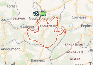
13,4 km | 17,5 km-effort
3h 58min
![](https://static1.geolcdn.com/siteimages/upload/files/16400158638029165_repeat_loop_refresh_sync_direction_icon.png)
Oui
![Randonnée Marche Pepinster - RB-Lg-23_Soiron - Photo](https://media.geolcdn.com/t/375/260/ext.jpg?maxdim=2&url=https%3A%2F%2Fservices.sitytrail.com%2FGeolivesWS%2FDownloadMedia.ashx%3FTrailID%3D400853%26Media%3D1646b7fd-8650-448d-bc3d-5efa9ed8c932.jpg)
![Marche Marche](https://static1.geolcdn.com/sitytour/trail-icons/101.png)
![Randonnée Marche Trooz - RB-Lg-03_Nessonvaux - Photo](https://media.geolcdn.com/t/375/260/ext.jpg?maxdim=2&url=https%3A%2F%2Fservices.sitytrail.com%2FGeolivesWS%2FDownloadMedia.ashx%3FTrailID%3D179559%26Media%3Dcef2de81-7d4f-4fcd-9e9d-f315370fe61f.jpg)
![Marche Marche](https://static1.geolcdn.com/sitytour/trail-icons/101.png)
RB-Lg-03_Nessonvaux
Marche
Moyen
(12)
Trooz,
Wallonie,
Liège,
Belgique
![](/images/other/stat-length.png)
22 km | 29 km-effort
6h 9min
![](https://static1.geolcdn.com/siteimages/upload/files/16400158638029165_repeat_loop_refresh_sync_direction_icon.png)
Oui
![Randonnée Marche Sprimont - Banneux - Rouge Thier - Adzeux - Photo](https://media.geolcdn.com/t/375/260/0f185ab2-d29a-4b49-b676-7a8415068951.jpg&format=jpg&maxdim=2)
![Marche Marche](https://static1.geolcdn.com/sitytour/trail-icons/101.png)
Banneux - Rouge Thier - Adzeux
Marche
Facile
(4)
Sprimont,
Wallonie,
Liège,
Belgique
![](/images/other/stat-length.png)
9,1 km | 11,3 km-effort
2h 34min
![](https://static1.geolcdn.com/siteimages/upload/files/16400158638029165_repeat_loop_refresh_sync_direction_icon.png)
Oui
![Randonnée Marche Pepinster - Soiron n°2 - Tribomont - Wegnez - Photo](https://media.geolcdn.com/t/375/260/ec8c930a-9871-4566-956d-2a2016034199.jpg&format=jpg&maxdim=2)
![Marche Marche](https://static1.geolcdn.com/sitytour/trail-icons/101.png)
Soiron n°2 - Tribomont - Wegnez
Marche
Facile
(1)
Pepinster,
Wallonie,
Liège,
Belgique
![](/images/other/stat-length.png)
9,5 km | 12,5 km-effort
2h 50min
![](https://static1.geolcdn.com/siteimages/upload/files/16400158638029165_repeat_loop_refresh_sync_direction_icon.png)
Oui
![Marche Marche](https://static1.geolcdn.com/sitytour/trail-icons/101.png)
20220307 - Saint-Hadelin 8.8 Km
Marche
Moyen
(1)
Olne,
Wallonie,
Liège,
Belgique
![](/images/other/stat-length.png)
8,4 km | 10,9 km-effort
2h 24min
![](https://static1.geolcdn.com/siteimages/upload/files/16400158638029165_repeat_loop_refresh_sync_direction_icon.png)
Oui
![Randonnée Marche Trooz - Balade de Fraipont - Photo](https://media.geolcdn.com/t/375/260/a22be754-a7d6-4ac7-b88b-6e30a6735908.jpg&format=jpg&maxdim=2)
![Marche Marche](https://static1.geolcdn.com/sitytour/trail-icons/101.png)
Balade de Fraipont
Marche
Moyen
(1)
Trooz,
Wallonie,
Liège,
Belgique
![](/images/other/stat-length.png)
12,3 km | 17,3 km-effort
3h 55min
![](https://static1.geolcdn.com/siteimages/upload/files/16400158638029165_repeat_loop_refresh_sync_direction_icon.png)
Oui
![Randonnée Marche Trooz - Forêt - Photo](https://media.geolcdn.com/t/375/260/d573d865-936c-49e5-ac73-8dda0a954532.jpg&format=jpg&maxdim=2)
![Marche Marche](https://static1.geolcdn.com/sitytour/trail-icons/101.png)
![Randonnée Marche Olne - Nessonvaux - Photo](https://media.geolcdn.com/t/375/260/8c16a020-3972-4fd4-95a4-e68b814bf4ee.jpg&format=jpg&maxdim=2)
![Marche Marche](https://static1.geolcdn.com/sitytour/trail-icons/101.png)
Faite en solo, 13 km, en sens inverse du balisage. A refaire ...