![](/images/other/stat-length.png)
![Randonnée A pied Gand - Door Luchteren en Oude Kale - Photo](https://media.geolcdn.com/t/1900/400/abded955-6a98-4333-a17f-cc251ab7d5c3.jpeg&format=pjpeg&maxdim=2)
Door Luchteren en Oude Kale
SityTrail - itinéraires balisés pédestres
Tous les sentiers balisés d’Europe GUIDE+
![Longueur](/images/other/stat-length.png)
Longueur
9,7 km
![Altitude max](https://static1.geolcdn.com/siteimages/upload/files/1508320355ic_sort_altitude_max_24dp.png)
Altitude max
12 m
![Dénivelé positif](https://static1.geolcdn.com/siteimages/upload/files/1508320355ic_sort_den_pos_24dp.png)
Dénivelé positif
51 m
![Km-Effort](/images/other/stat-length.png)
Km-Effort
10,4 km
![Altitude min](https://static1.geolcdn.com/siteimages/upload/files/1508320355ic_sort_altitude_min_24dp.png)
Altitude min
1 m
![Dénivelé négatif](https://static1.geolcdn.com/siteimages/upload/files/1508320355ic_sort_den_neg_24dp.png)
Dénivelé négatif
51 m
![Boucle](https://static1.geolcdn.com/siteimages/upload/files/16400158638029165_repeat_loop_refresh_sync_direction_icon.png)
Boucle
Oui
Balise
Date de création :
2022-02-09 19:24:26.936
Dernière modification :
2022-03-10 10:44:23.174
![A pied](https://static1.geolcdn.com/sitytour/trail-icons/100.png)
2h21
Difficulté : Facile
![Scannez ce code QR pour ouvrir la randonnée dans l'application SityTrail](https://capi.geolives.com/qq0zvz2zws4bq2lad0pu/sitytour/trails/3085396/qr.png?size=200)
Application GPS de randonnée GRATUITE
À propos
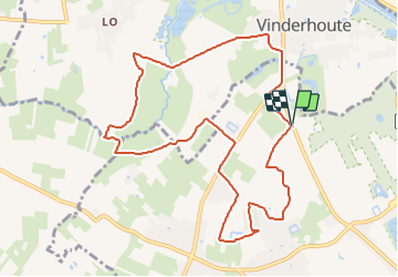
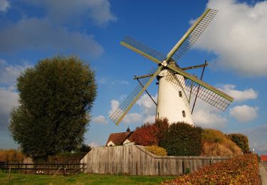
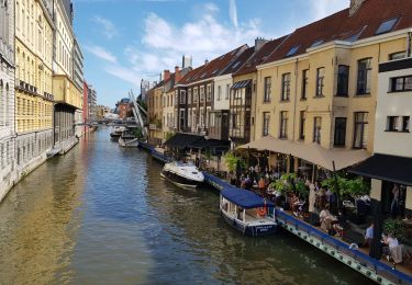
Randonnée A pied de 9,7 km à découvrir à Flandre, Flandre orientale, Gand. Cette randonnée est proposée par SityTrail - itinéraires balisés pédestres.
Description
Randonnée créée par Vlaamse landmaatschappij.
Symbole: cross
Site web: https://www.vlm.be/nl/groenpool-vinderhoutse-bossen
Localisation
Pays :
Belgique
Région :
Flandre
Département/Province :
Flandre orientale
Commune :
Gand
Localité :
Tronchiennes
Départ:(Dec)
Départ:(UTM)
544792 ; 5658666 (31U) N.
Commentaires
Randonnées à proximité
![Vélo électrique Vélo électrique](https://static1.geolcdn.com/sitytour/trail-icons/205.png)
fietstocht 13-06-2021 sterretrappers
Vélo électrique
Très facile
(1)
Gand,
Flandre,
Flandre orientale,
Belgique
![](/images/other/stat-length.png)
33 km | 36 km-effort
Inconnu
![](https://static1.geolcdn.com/siteimages/upload/files/16400158638029165_repeat_loop_refresh_sync_direction_icon.png)
Oui
![Randonnée A pied Gand - Vinderhoutse Bossen wandeling - Photo](https://media.geolcdn.com/t/375/260/572659ee-7cae-4b58-81f1-828035b8848e.jpeg&format=jpg&maxdim=2)
![A pied A pied](https://static1.geolcdn.com/sitytour/trail-icons/100.png)
Vinderhoutse Bossen wandeling
A pied
Facile
Gand,
Flandre,
Flandre orientale,
Belgique
![](/images/other/stat-length.png)
9,8 km | 10,6 km-effort
2h 24min
![](https://static1.geolcdn.com/siteimages/upload/files/16400158638029165_repeat_loop_refresh_sync_direction_icon.png)
Oui
![Randonnée A pied Gand - Campagne wandeling - Photo](https://media.geolcdn.com/t/375/260/3d89c286-67ac-4ed8-9d51-a3e73cef8982.jpeg&format=jpg&maxdim=2)
![A pied A pied](https://static1.geolcdn.com/sitytour/trail-icons/100.png)
Campagne wandeling
A pied
Facile
Gand,
Flandre,
Flandre orientale,
Belgique
![](/images/other/stat-length.png)
7 km | 7,5 km-effort
1h 41min
![](https://static1.geolcdn.com/siteimages/upload/files/16400158638029165_repeat_loop_refresh_sync_direction_icon.png)
Oui
![Randonnée A pied Gand - Claeys-Boúúaert wandeling - Photo](https://media.geolcdn.com/t/375/260/921051f5-906e-47ac-b9c1-2a14046aee3f.jpeg&format=jpg&maxdim=2)
![A pied A pied](https://static1.geolcdn.com/sitytour/trail-icons/100.png)
Claeys-Boúúaert wandeling
A pied
Facile
Gand,
Flandre,
Flandre orientale,
Belgique
![](/images/other/stat-length.png)
9,3 km | 10 km-effort
2h 15min
![](https://static1.geolcdn.com/siteimages/upload/files/16400158638029165_repeat_loop_refresh_sync_direction_icon.png)
Oui
![Randonnée A pied Gand - Leeuwenhof wandeling - Photo](https://media.geolcdn.com/t/375/260/d9bc68bb-84e4-43b5-bfa1-638e3a2ebc41.jpeg&format=jpg&maxdim=2)
![A pied A pied](https://static1.geolcdn.com/sitytour/trail-icons/100.png)
Leeuwenhof wandeling
A pied
Facile
Gand,
Flandre,
Flandre orientale,
Belgique
![](/images/other/stat-length.png)
4,4 km | 4,8 km-effort
1h 4min
![](https://static1.geolcdn.com/siteimages/upload/files/16400158638029165_repeat_loop_refresh_sync_direction_icon.png)
Oui
![Randonnée A pied Gand - Le Bourgoyen : Balade dans la vallée de la Leie gantoise - Photo](https://media.geolcdn.com/t/375/260/d0c2b3a9-5166-4f7a-9c9b-65fdd66fe07a.jpeg&format=jpg&maxdim=2)
![A pied A pied](https://static1.geolcdn.com/sitytour/trail-icons/100.png)
Le Bourgoyen : Balade dans la vallée de la Leie gantoise
A pied
Facile
Gand,
Flandre,
Flandre orientale,
Belgique
![](/images/other/stat-length.png)
5,1 km | 5,7 km-effort
1h 18min
![](https://static1.geolcdn.com/siteimages/upload/files/16400158638029165_repeat_loop_refresh_sync_direction_icon.png)
Oui
![Randonnée A pied Deinze - Slodderspookroute - Photo](https://media.geolcdn.com/t/375/260/6b52d7a5-3827-4ad9-b4b7-3ab4a653d6fb.jpeg&format=jpg&maxdim=2)
![A pied A pied](https://static1.geolcdn.com/sitytour/trail-icons/100.png)
Slodderspookroute
A pied
Facile
Deinze,
Flandre,
Flandre orientale,
Belgique
![](/images/other/stat-length.png)
8,7 km | 9,4 km-effort
2h 7min
![](https://static1.geolcdn.com/siteimages/upload/files/16400158638029165_repeat_loop_refresh_sync_direction_icon.png)
Oui
![Randonnée A pied Deinze - Oude Kalevallei - Lus 2 - Photo](https://media.geolcdn.com/t/375/260/9a68d079-d324-441f-ab36-1b80e1608fb1.jpeg&format=jpg&maxdim=2)
![A pied A pied](https://static1.geolcdn.com/sitytour/trail-icons/100.png)
Oude Kalevallei - Lus 2
A pied
Facile
Deinze,
Flandre,
Flandre orientale,
Belgique
![](/images/other/stat-length.png)
3,7 km | 3,9 km-effort
53min
![](https://static1.geolcdn.com/siteimages/upload/files/16400158638029165_repeat_loop_refresh_sync_direction_icon.png)
Oui
![Randonnée Marche Gand - Gand - Photo](https://media.geolcdn.com/t/375/260/becae5b4-1bd8-4ed9-a858-eb6535ae6c85.jpg&format=jpg&maxdim=2)
![Marche Marche](https://static1.geolcdn.com/sitytour/trail-icons/101.png)
Gand
Marche
Très facile
(1)
Gand,
Flandre,
Flandre orientale,
Belgique
![](/images/other/stat-length.png)
11,5 km | 12,5 km-effort
2h 40min
![](https://static1.geolcdn.com/siteimages/upload/files/16400158638029165_repeat_loop_refresh_sync_direction_icon.png)
Non