![](/images/other/stat-length.png)
![Randonnée A pied Hélécine - Promenade de la colombe - Photo](https://media.geolcdn.com/t/1900/400/0e42a69d-2b43-4abc-b8c8-f2acea9608dc.jpeg&format=pjpeg&maxdim=2)
Promenade de la colombe
SityTrail - itinéraires balisés pédestres
Tous les sentiers balisés d’Europe GUIDE+
![Longueur](/images/other/stat-length.png)
Longueur
10,6 km
![Altitude max](https://static1.geolcdn.com/siteimages/upload/files/1508320355ic_sort_altitude_max_24dp.png)
Altitude max
88 m
![Dénivelé positif](https://static1.geolcdn.com/siteimages/upload/files/1508320355ic_sort_den_pos_24dp.png)
Dénivelé positif
96 m
![Km-Effort](/images/other/stat-length.png)
Km-Effort
11,9 km
![Altitude min](https://static1.geolcdn.com/siteimages/upload/files/1508320355ic_sort_altitude_min_24dp.png)
Altitude min
49 m
![Dénivelé négatif](https://static1.geolcdn.com/siteimages/upload/files/1508320355ic_sort_den_neg_24dp.png)
Dénivelé négatif
96 m
![Boucle](https://static1.geolcdn.com/siteimages/upload/files/16400158638029165_repeat_loop_refresh_sync_direction_icon.png)
Boucle
Oui
Balise
Date de création :
2022-02-09 19:04:18.918
Dernière modification :
2022-02-09 19:04:18.918
![A pied](https://static1.geolcdn.com/sitytour/trail-icons/100.png)
2h42
Difficulté : Facile
![Scannez ce code QR pour ouvrir la randonnée dans l'application SityTrail](https://capi.geolives.com/qq0zvz2zws4bq2lad0pu/sitytour/trails/3085087/qr.png?size=200)
Application GPS de randonnée GRATUITE
À propos
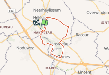
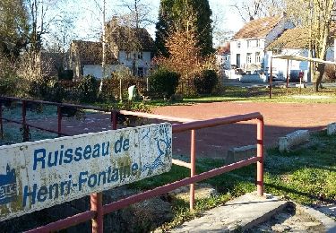
Randonnée A pied de 10,6 km à découvrir à Wallonie, Brabant wallon, Hélécine. Cette randonnée est proposée par SityTrail - itinéraires balisés pédestres.
Description
Randonnée créée par Maison du Tourisme Hesbaye Brabançonne.
Symbole: A red background
Localisation
Pays :
Belgique
Région :
Wallonie
Département/Province :
Brabant wallon
Commune :
Hélécine
Localité :
Opheylissem
Départ:(Dec)
Départ:(UTM)
639852 ; 5623105 (31U) N.
Commentaires
Randonnées à proximité
![Randonnée Marche Orp-Jauche - RB-Bw-01 - Orp-le-Grand - Photo](https://media.geolcdn.com/t/375/260/ext.jpg?maxdim=2&url=https%3A%2F%2Fservices.sitytrail.com%2FGeolivesWS%2FDownloadMedia.ashx%3FTrailID%3D218532%26Media%3D2b25bbe0-0fd5-407f-bf14-f349bb03461d.jpg)
![Marche Marche](https://static1.geolcdn.com/sitytour/trail-icons/101.png)
RB-Bw-01 - Orp-le-Grand
Marche
Moyen
(2)
Orp-Jauche,
Wallonie,
Brabant wallon,
Belgique
![](/images/other/stat-length.png)
20 km | 23 km-effort
5h 46min
![](https://static1.geolcdn.com/siteimages/upload/files/16400158638029165_repeat_loop_refresh_sync_direction_icon.png)
Oui
![Randonnée Marche Orp-Jauche - RB-Bw-01 - Orp-le-Grand - Via variante - Photo](https://media.geolcdn.com/t/375/260/ext.jpg?maxdim=2&url=https%3A%2F%2Fservices.sitytrail.com%2FGeolivesWS%2FDownloadMedia.ashx%3FTrailID%3D179575%26Media%3D1fb01559-2292-4faf-8acf-655ff0b406da.jpg)
![Marche Marche](https://static1.geolcdn.com/sitytour/trail-icons/101.png)
RB-Bw-01 - Orp-le-Grand - Via variante
Marche
Moyen
(2)
Orp-Jauche,
Wallonie,
Brabant wallon,
Belgique
![](/images/other/stat-length.png)
25 km | 29 km-effort
6h 30min
![](https://static1.geolcdn.com/siteimages/upload/files/16400158638029165_repeat_loop_refresh_sync_direction_icon.png)
Oui
![Randonnée Marche Orp-Jauche - RB-Bw-01 - Orp-le-Grand - Via raccourci - Photo](https://media.geolcdn.com/t/375/260/ext.jpg?maxdim=2&url=https%3A%2F%2Fservices.sitytrail.com%2FGeolivesWS%2FDownloadMedia.ashx%3FTrailID%3D218537%26Media%3D2b25bbe0-0fd5-407f-bf14-f349bb03461d.jpg)
![Marche Marche](https://static1.geolcdn.com/sitytour/trail-icons/101.png)
RB-Bw-01 - Orp-le-Grand - Via raccourci
Marche
Moyen
(3)
Orp-Jauche,
Wallonie,
Brabant wallon,
Belgique
![](/images/other/stat-length.png)
17,2 km | 19,4 km-effort
4h 31min
![](https://static1.geolcdn.com/siteimages/upload/files/16400158638029165_repeat_loop_refresh_sync_direction_icon.png)
Oui
![Randonnée Marche Orp-Jauche - Orp le Grand Nathalie Demain 29 11 2016 - Photo](https://media.geolcdn.com/t/375/260/ext.jpg?maxdim=2&url=https%3A%2F%2Fservices.sitytrail.com%2FGeolivesWS%2FDownloadMedia.ashx%3FTrailID%3D666139%26Media%3Dfix__20161129124748.jpg)
![Marche Marche](https://static1.geolcdn.com/sitytour/trail-icons/101.png)
Orp le Grand Nathalie Demain 29 11 2016
Marche
Facile
(3)
Orp-Jauche,
Wallonie,
Brabant wallon,
Belgique
![](/images/other/stat-length.png)
16,6 km | 18,9 km-effort
6h 52min
![](https://static1.geolcdn.com/siteimages/upload/files/16400158638029165_repeat_loop_refresh_sync_direction_icon.png)
Oui
![Randonnée A pied Jodoigne - Promenade de la chapelle d'Herbais - Photo](https://media.geolcdn.com/t/375/260/9aa9d8fc-8d5f-4ab8-a073-3c93152fc20d.jpeg&format=jpg&maxdim=2)
![A pied A pied](https://static1.geolcdn.com/sitytour/trail-icons/100.png)
Promenade de la chapelle d'Herbais
A pied
Facile
Jodoigne,
Wallonie,
Brabant wallon,
Belgique
![](/images/other/stat-length.png)
8,5 km | 9,6 km-effort
2h 10min
![](https://static1.geolcdn.com/siteimages/upload/files/16400158638029165_repeat_loop_refresh_sync_direction_icon.png)
Oui
![Randonnée A pied Hélécine - Promenade de la colombe (alternative) - Photo](https://media.geolcdn.com/t/375/260/0e42a69d-2b43-4abc-b8c8-f2acea9608dc.jpeg&format=jpg&maxdim=2)
![A pied A pied](https://static1.geolcdn.com/sitytour/trail-icons/100.png)
Promenade de la colombe (alternative)
A pied
Facile
(1)
Hélécine,
Wallonie,
Brabant wallon,
Belgique
![](/images/other/stat-length.png)
7,2 km | 8 km-effort
1h 49min
![](https://static1.geolcdn.com/siteimages/upload/files/16400158638029165_repeat_loop_refresh_sync_direction_icon.png)
Oui
![Randonnée A pied Hélécine - Promenade des chavées - Photo](https://media.geolcdn.com/t/375/260/0e42a69d-2b43-4abc-b8c8-f2acea9608dc.jpeg&format=jpg&maxdim=2)
![A pied A pied](https://static1.geolcdn.com/sitytour/trail-icons/100.png)
Promenade des chavées
A pied
Facile
(1)
Hélécine,
Wallonie,
Brabant wallon,
Belgique
![](/images/other/stat-length.png)
11 km | 12,6 km-effort
2h 51min
![](https://static1.geolcdn.com/siteimages/upload/files/16400158638029165_repeat_loop_refresh_sync_direction_icon.png)
Oui
![Randonnée A pied Hélécine - Promenade des chavées (alternative 1) - Photo](https://media.geolcdn.com/t/375/260/0e42a69d-2b43-4abc-b8c8-f2acea9608dc.jpeg&format=jpg&maxdim=2)
![A pied A pied](https://static1.geolcdn.com/sitytour/trail-icons/100.png)
Promenade des chavées (alternative 1)
A pied
Facile
Hélécine,
Wallonie,
Brabant wallon,
Belgique
![](/images/other/stat-length.png)
9,4 km | 10,7 km-effort
2h 25min
![](https://static1.geolcdn.com/siteimages/upload/files/16400158638029165_repeat_loop_refresh_sync_direction_icon.png)
Oui
![Randonnée A pied Hélécine - Promenade des chavées (alternative 2) - Photo](https://media.geolcdn.com/t/375/260/0e42a69d-2b43-4abc-b8c8-f2acea9608dc.jpeg&format=jpg&maxdim=2)
![A pied A pied](https://static1.geolcdn.com/sitytour/trail-icons/100.png)
Promenade des chavées (alternative 2)
A pied
Facile
(2)
Hélécine,
Wallonie,
Brabant wallon,
Belgique
![](/images/other/stat-length.png)
6,5 km | 7,4 km-effort
1h 41min
![](https://static1.geolcdn.com/siteimages/upload/files/16400158638029165_repeat_loop_refresh_sync_direction_icon.png)
Oui