![](/images/other/stat-length.png)
![Randonnée A pied Aubange - BE-AU 01 - Photo](https://media.geolcdn.com/t/1900/400/7f7289b5-d5ab-4003-b78e-f5dd73f8883f.jpeg&format=pjpeg&maxdim=2)
BE-AU 01
SityTrail - itinéraires balisés pédestres
Tous les sentiers balisés d’Europe GUIDE+
![Longueur](/images/other/stat-length.png)
Longueur
12,2 km
![Altitude max](https://static1.geolcdn.com/siteimages/upload/files/1508320355ic_sort_altitude_max_24dp.png)
Altitude max
383 m
![Dénivelé positif](https://static1.geolcdn.com/siteimages/upload/files/1508320355ic_sort_den_pos_24dp.png)
Dénivelé positif
198 m
![Km-Effort](/images/other/stat-length.png)
Km-Effort
14,9 km
![Altitude min](https://static1.geolcdn.com/siteimages/upload/files/1508320355ic_sort_altitude_min_24dp.png)
Altitude min
282 m
![Dénivelé négatif](https://static1.geolcdn.com/siteimages/upload/files/1508320355ic_sort_den_neg_24dp.png)
Dénivelé négatif
198 m
![Boucle](https://static1.geolcdn.com/siteimages/upload/files/16400158638029165_repeat_loop_refresh_sync_direction_icon.png)
Boucle
Oui
Balise
Date de création :
2022-02-09 18:55:11.562
Dernière modification :
2022-02-09 18:55:11.562
![A pied](https://static1.geolcdn.com/sitytour/trail-icons/100.png)
3h22
Difficulté : Facile
![Scannez ce code QR pour ouvrir la randonnée dans l'application SityTrail](https://capi.geolives.com/qq0zvz2zws4bq2lad0pu/sitytour/trails/3084893/qr.png?size=200)
Application GPS de randonnée GRATUITE
À propos
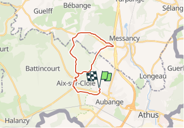
Randonnée A pied de 12,2 km à découvrir à Wallonie, Luxembourg, Aubange. Cette randonnée est proposée par SityTrail - itinéraires balisés pédestres.
Description
Randonnée créée par SI Aubange 32 63 38 68 54.
Symbole: yellow rectangle on white ground
Site web: http://www.visitaubange.be
Localisation
Pays :
Belgique
Région :
Wallonie
Département/Province :
Luxembourg
Commune :
Aubange
Localité :
Aubange
Départ:(Dec)
Départ:(UTM)
702257 ; 5494939 (31U) N.
Commentaires
Randonnées à proximité
![Randonnée Marche Messancy - Selange - Photo](https://media.geolcdn.com/t/375/260/ext.jpg?maxdim=2&url=https%3A%2F%2Fservices.sitytrail.com%2FGeolivesWS%2FDownloadMedia.ashx%3FTrailID%3D224271%26Media%3Dfix__20130929133132.jpg)
![Marche Marche](https://static1.geolcdn.com/sitytour/trail-icons/101.png)
Selange
Marche
Facile
(1)
Messancy,
Wallonie,
Luxembourg,
Belgique
![](/images/other/stat-length.png)
11,1 km | 13,7 km-effort
2h 35min
![](https://static1.geolcdn.com/siteimages/upload/files/16400158638029165_repeat_loop_refresh_sync_direction_icon.png)
Oui
![Randonnée A pied Pétange - Auto-Pédestre Lamadelaine - Photo](https://media.geolcdn.com/t/375/260/b8abde83-d7ee-4d08-8b56-7c6d44fc17fc.jpeg&format=jpg&maxdim=2)
![A pied A pied](https://static1.geolcdn.com/sitytour/trail-icons/100.png)
Auto-Pédestre Lamadelaine
A pied
Facile
Pétange,
Inconnu,
Canton Esch-sur-Alzette,
Luxembourg
![](/images/other/stat-length.png)
10,8 km | 13,4 km-effort
3h 2min
![](https://static1.geolcdn.com/siteimages/upload/files/16400158638029165_repeat_loop_refresh_sync_direction_icon.png)
Oui
![Randonnée A pied Aubange - Le Joli Bois - Photo](https://media.geolcdn.com/t/375/260/004d9deb-44d3-48df-b1f8-dbcc850899c2.jpeg&format=jpg&maxdim=2)
![A pied A pied](https://static1.geolcdn.com/sitytour/trail-icons/100.png)
Le Joli Bois
A pied
Facile
Aubange,
Wallonie,
Luxembourg,
Belgique
![](/images/other/stat-length.png)
8,5 km | 11,7 km-effort
2h 39min
![](https://static1.geolcdn.com/siteimages/upload/files/16400158638029165_repeat_loop_refresh_sync_direction_icon.png)
Oui
![Randonnée A pied Messancy - Promenade de Bébange - Photo](https://media.geolcdn.com/t/375/260/ext.jpg?maxdim=2&url=https%3A%2F%2Fpivotmedia.tourismewallonie.be%2FOTH-A0-0061-225L%2FOTH-A0-0061-225L.jpg)
![A pied A pied](https://static1.geolcdn.com/sitytour/trail-icons/100.png)
Promenade de Bébange
A pied
Facile
(1)
Messancy,
Wallonie,
Luxembourg,
Belgique
![](/images/other/stat-length.png)
6 km | 7,5 km-effort
1h 41min
![](https://static1.geolcdn.com/siteimages/upload/files/16400158638029165_repeat_loop_refresh_sync_direction_icon.png)
Oui
![Randonnée A pied Messancy - Promenade d'Habergy - Photo](https://media.geolcdn.com/t/375/260/ext.jpg?maxdim=2&url=https%3A%2F%2Fpivotmedia.tourismewallonie.be%2FOTH-A0-0062-14VV%2FOTH-A0-0062-14VV.jpg)
![A pied A pied](https://static1.geolcdn.com/sitytour/trail-icons/100.png)
Promenade d'Habergy
A pied
Facile
Messancy,
Wallonie,
Luxembourg,
Belgique
![](/images/other/stat-length.png)
6,7 km | 8,4 km-effort
1h 54min
![](https://static1.geolcdn.com/siteimages/upload/files/16400158638029165_repeat_loop_refresh_sync_direction_icon.png)
Oui
![Randonnée A pied Messancy - Promenade de Sélange - Photo](https://media.geolcdn.com/t/375/260/ext.jpg?maxdim=2&url=https%3A%2F%2Fpivotmedia.tourismewallonie.be%2FOTH-A0-0062-15WM%2FOTH-A0-0062-15WM.jpg)
![A pied A pied](https://static1.geolcdn.com/sitytour/trail-icons/100.png)
Promenade de Sélange
A pied
Facile
Messancy,
Wallonie,
Luxembourg,
Belgique
![](/images/other/stat-length.png)
10,2 km | 12,6 km-effort
2h 52min
![](https://static1.geolcdn.com/siteimages/upload/files/16400158638029165_repeat_loop_refresh_sync_direction_icon.png)
Oui
![Randonnée Marche Aubange - Marche ADEPES Halanzy - Photo](https://media.geolcdn.com/t/375/260/c1b4404e-4c17-4362-a764-47cc40fd5191.jpg&format=jpg&maxdim=2)
![Marche Marche](https://static1.geolcdn.com/sitytour/trail-icons/101.png)
Marche ADEPES Halanzy
Marche
Moyen
Aubange,
Wallonie,
Luxembourg,
Belgique
![](/images/other/stat-length.png)
11,3 km | 14,1 km-effort
2h 15min
![](https://static1.geolcdn.com/siteimages/upload/files/16400158638029165_repeat_loop_refresh_sync_direction_icon.png)
Oui
![Randonnée Marche Aubange - RL-GG-33_Halanzy_Messancy - Photo](https://media.geolcdn.com/t/375/260/9d50722e-12e0-424a-b4f8-252d1e9dd93c.jpg&format=jpg&maxdim=2)
![Marche Marche](https://static1.geolcdn.com/sitytour/trail-icons/101.png)
RL-GG-33_Halanzy_Messancy
Marche
Très difficile
Aubange,
Wallonie,
Luxembourg,
Belgique
![](/images/other/stat-length.png)
22 km | 29 km-effort
6h 31min
![](https://static1.geolcdn.com/siteimages/upload/files/16400158638029165_repeat_loop_refresh_sync_direction_icon.png)
Non
![Randonnée Marche Aubange - HALANZY Sentier des Mines de Fer - Photo](https://media.geolcdn.com/t/375/260/ext.jpg?maxdim=2&url=https%3A%2F%2Fstatic1.geolcdn.com%2Fsiteimages%2Fupload%2Ffiles%2F1553511878bg_sport_marche.png)
![Marche Marche](https://static1.geolcdn.com/sitytour/trail-icons/101.png)
HALANZY Sentier des Mines de Fer
Marche
Moyen
(1)
Aubange,
Wallonie,
Luxembourg,
Belgique
![](/images/other/stat-length.png)
8,3 km | 10,9 km-effort
2h 22min
![](https://static1.geolcdn.com/siteimages/upload/files/16400158638029165_repeat_loop_refresh_sync_direction_icon.png)
Oui