![](/images/other/stat-length.png)
![Randonnée A pied Avelgem - Bouvrie wandelroute - Photo](https://media.geolcdn.com/t/1900/400/545033be-3693-4987-a9ee-3d2a17148c1c.jpeg&format=pjpeg&maxdim=2)
Bouvrie wandelroute
SityTrail - itinéraires balisés pédestres
Tous les sentiers balisés d’Europe GUIDE+
![Longueur](/images/other/stat-length.png)
Longueur
5,8 km
![Altitude max](https://static1.geolcdn.com/siteimages/upload/files/1508320355ic_sort_altitude_max_24dp.png)
Altitude max
25 m
![Dénivelé positif](https://static1.geolcdn.com/siteimages/upload/files/1508320355ic_sort_den_pos_24dp.png)
Dénivelé positif
33 m
![Km-Effort](/images/other/stat-length.png)
Km-Effort
6,3 km
![Altitude min](https://static1.geolcdn.com/siteimages/upload/files/1508320355ic_sort_altitude_min_24dp.png)
Altitude min
10 m
![Dénivelé négatif](https://static1.geolcdn.com/siteimages/upload/files/1508320355ic_sort_den_neg_24dp.png)
Dénivelé négatif
32 m
![Boucle](https://static1.geolcdn.com/siteimages/upload/files/16400158638029165_repeat_loop_refresh_sync_direction_icon.png)
Boucle
Oui
Balise
Date de création :
2022-02-09 15:08:17.987
Dernière modification :
2022-02-09 17:54:23.482
![A pied](https://static1.geolcdn.com/sitytour/trail-icons/100.png)
1h25
Difficulté : Facile
![Scannez ce code QR pour ouvrir la randonnée dans l'application SityTrail](https://capi.geolives.com/qq0zvz2zws4bq2lad0pu/sitytour/trails/3083378/qr.png?size=200)
Application GPS de randonnée GRATUITE
À propos
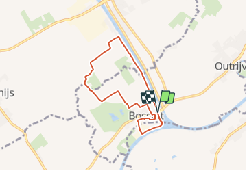
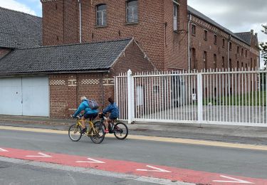
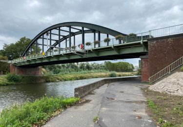
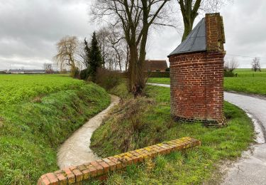
Randonnée A pied de 5,8 km à découvrir à Flandre, Flandre-Occidentale, Avelgem. Cette randonnée est proposée par SityTrail - itinéraires balisés pédestres.
Description
De Bouvriewandelroute leidt je langs imposante hoeven, glooiende akkers en uitgestrekte meersen in en rond Bossuit.
Localisation
Pays :
Belgique
Région :
Flandre
Département/Province :
Flandre-Occidentale
Commune :
Avelgem
Localité :
Bossuit
Départ:(Dec)
Départ:(UTM)
528996 ; 5621941 (31U) N.
Commentaires
Randonnées à proximité
![Randonnée A pied Zwevegem - Orveyt - Photo](https://media.geolcdn.com/t/375/260/307f08f0-a102-4a61-b235-87ca367cbf69.jpeg&format=jpg&maxdim=2)
![A pied A pied](https://static1.geolcdn.com/sitytour/trail-icons/100.png)
Orveyt
A pied
Facile
Zwevegem,
Flandre,
Flandre-Occidentale,
Belgique
![](/images/other/stat-length.png)
6,7 km | 7,6 km-effort
1h 43min
![](https://static1.geolcdn.com/siteimages/upload/files/16400158638029165_repeat_loop_refresh_sync_direction_icon.png)
Oui
![Randonnée A pied Celles - 3.36 La boucle du Château du Quesnoy - Photo](https://media.geolcdn.com/t/375/260/ext.jpg?maxdim=2&url=https%3A%2F%2Fpivotmedia.tourismewallonie.be%2FANX-02-000JP5%2FANX-02-000JP5.jpg)
![A pied A pied](https://static1.geolcdn.com/sitytour/trail-icons/100.png)
3.36 La boucle du Château du Quesnoy
A pied
Facile
(1)
Celles,
Wallonie,
Hainaut,
Belgique
![](/images/other/stat-length.png)
7,5 km | 7,9 km-effort
1h 47min
![](https://static1.geolcdn.com/siteimages/upload/files/16400158638029165_repeat_loop_refresh_sync_direction_icon.png)
Oui
![Randonnée Cheval Celles - 3.07 Boucle de Celles - Photo](https://media.geolcdn.com/t/375/260/ext.jpg?maxdim=2&url=https%3A%2F%2Fpivotmedia.tourismewallonie.be%2FANX-02-000EJO%2FANX-02-000EJO.jpg)
![Cheval Cheval](https://static1.geolcdn.com/sitytour/trail-icons/300.png)
3.07 Boucle de Celles
Cheval
Très facile
Celles,
Wallonie,
Hainaut,
Belgique
![](/images/other/stat-length.png)
34 km | 37 km-effort
Inconnu
![](https://static1.geolcdn.com/siteimages/upload/files/16400158638029165_repeat_loop_refresh_sync_direction_icon.png)
Oui
![Randonnée A pied Mont-de-l’Enclus - Entre Flandre et Wallonie - Photo](https://media.geolcdn.com/t/375/260/ext.jpg?maxdim=2&url=https%3A%2F%2Fpivotmedia.tourismewallonie.be%2FANX-02-000ENY%2FANX-02-000ENY.jpg)
![A pied A pied](https://static1.geolcdn.com/sitytour/trail-icons/100.png)
Entre Flandre et Wallonie
A pied
Moyen
(2)
Mont-de-l’Enclus,
Wallonie,
Hainaut,
Belgique
![](/images/other/stat-length.png)
18,6 km | 22 km-effort
5h 4min
![](https://static1.geolcdn.com/siteimages/upload/files/16400158638029165_repeat_loop_refresh_sync_direction_icon.png)
Oui
![Randonnée A pied Mont-de-l’Enclus - Entre Orroir et Ruien - Photo](https://media.geolcdn.com/t/375/260/ext.jpg?maxdim=2&url=https%3A%2F%2Fpivotmedia.tourismewallonie.be%2FANX-02-000EUH%2FANX-02-000EUH.jpg)
![A pied A pied](https://static1.geolcdn.com/sitytour/trail-icons/100.png)
Entre Orroir et Ruien
A pied
Facile
Mont-de-l’Enclus,
Wallonie,
Hainaut,
Belgique
![](/images/other/stat-length.png)
9 km | 12,5 km-effort
2h 51min
![](https://static1.geolcdn.com/siteimages/upload/files/16400158638029165_repeat_loop_refresh_sync_direction_icon.png)
Non
![Randonnée Marche Zwevegem - sint petersburg - Photo](https://media.geolcdn.com/t/375/260/ext.jpg?maxdim=2&url=https%3A%2F%2Fstatic1.geolcdn.com%2Fsiteimages%2Fupload%2Ffiles%2F1553511878bg_sport_marche.png)
![Marche Marche](https://static1.geolcdn.com/sitytour/trail-icons/101.png)
sint petersburg
Marche
Très facile
(1)
Zwevegem,
Flandre,
Flandre-Occidentale,
Belgique
![](/images/other/stat-length.png)
6,7 km | 7,6 km-effort
1h 14min
![](https://static1.geolcdn.com/siteimages/upload/files/16400158638029165_repeat_loop_refresh_sync_direction_icon.png)
Oui
![Randonnée Marche Pecq - Warcoing Helchin - Photo](https://media.geolcdn.com/t/375/260/017cef9b-0ba9-4739-814b-a49c1832694e.jpeg&format=jpg&maxdim=2)
![Marche Marche](https://static1.geolcdn.com/sitytour/trail-icons/101.png)
Warcoing Helchin
Marche
Très facile
Pecq,
Wallonie,
Hainaut,
Belgique
![](/images/other/stat-length.png)
5,7 km | 6,1 km-effort
1h 18min
![](https://static1.geolcdn.com/siteimages/upload/files/16400158638029165_repeat_loop_refresh_sync_direction_icon.png)
Oui
![Randonnée Marche Celles - Escanaffles 11 Km - Photo](https://media.geolcdn.com/t/375/260/caf3c348-a8bd-4e11-a9e8-e1b45c716e49.jpg&format=jpg&maxdim=2)
![Marche Marche](https://static1.geolcdn.com/sitytour/trail-icons/101.png)
Escanaffles 11 Km
Marche
Très facile
Celles,
Wallonie,
Hainaut,
Belgique
![](/images/other/stat-length.png)
12,9 km | 13,8 km-effort
2h 28min
![](https://static1.geolcdn.com/siteimages/upload/files/16400158638029165_repeat_loop_refresh_sync_direction_icon.png)
Oui
![Randonnée Marche Zwevegem - Sint denijs 17 Km - Photo](https://media.geolcdn.com/t/375/260/627a45ec-0584-476c-b3d1-3be059107ecf.jpg&format=jpg&maxdim=2)
![Marche Marche](https://static1.geolcdn.com/sitytour/trail-icons/101.png)
Sint denijs 17 Km
Marche
Moyen
Zwevegem,
Flandre,
Flandre-Occidentale,
Belgique
![](/images/other/stat-length.png)
17 km | 19,4 km-effort
3h 59min
![](https://static1.geolcdn.com/siteimages/upload/files/16400158638029165_repeat_loop_refresh_sync_direction_icon.png)
Oui