![](/images/other/stat-length.png)
![Randonnée A pied Oostkamp - Meersen wandelroute - Photo](https://media.geolcdn.com/t/1900/400/f2c5a60a-a73e-4cc6-a91f-c7d48fe602b2.jpeg&format=pjpeg&maxdim=2)
Meersen wandelroute
SityTrail - itinéraires balisés pédestres
Tous les sentiers balisés d’Europe GUIDE+
![Longueur](/images/other/stat-length.png)
Longueur
7 km
![Altitude max](https://static1.geolcdn.com/siteimages/upload/files/1508320355ic_sort_altitude_max_24dp.png)
Altitude max
16 m
![Dénivelé positif](https://static1.geolcdn.com/siteimages/upload/files/1508320355ic_sort_den_pos_24dp.png)
Dénivelé positif
61 m
![Km-Effort](/images/other/stat-length.png)
Km-Effort
7,8 km
![Altitude min](https://static1.geolcdn.com/siteimages/upload/files/1508320355ic_sort_altitude_min_24dp.png)
Altitude min
-1 m
![Dénivelé négatif](https://static1.geolcdn.com/siteimages/upload/files/1508320355ic_sort_den_neg_24dp.png)
Dénivelé négatif
60 m
![Boucle](https://static1.geolcdn.com/siteimages/upload/files/16400158638029165_repeat_loop_refresh_sync_direction_icon.png)
Boucle
Oui
Balise
Date de création :
2022-02-09 15:07:52.83
Dernière modification :
2022-02-09 17:54:08.469
![A pied](https://static1.geolcdn.com/sitytour/trail-icons/100.png)
1h46
Difficulté : Facile
![Scannez ce code QR pour ouvrir la randonnée dans l'application SityTrail](https://capi.geolives.com/qq0zvz2zws4bq2lad0pu/sitytour/trails/3083361/qr.png?size=200)
Application GPS de randonnée GRATUITE
À propos
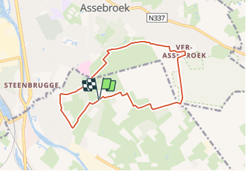
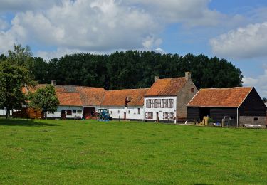
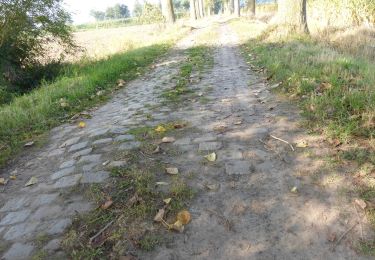
Randonnée A pied de 7 km à découvrir à Flandre, Flandre-Occidentale, Oostkamp. Cette randonnée est proposée par SityTrail - itinéraires balisés pédestres.
Description
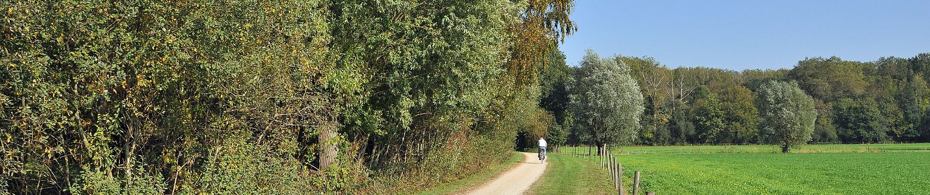
Op de Meersenwandelroute staat het landschap van de Assebroekse Meersen centraal. Dit 420 ha beschermd gebied ligt op de grens met Brugge, Beernem en Oostkamp.
Localisation
Pays :
Belgique
Région :
Flandre
Département/Province :
Flandre-Occidentale
Commune :
Oostkamp
Localité :
Oostkamp
Départ:(Dec)
Départ:(UTM)
517640 ; 5669896 (31U) N.
Commentaires
Randonnées à proximité
![Randonnée Marche Bruges - Le meilleur de Bruges - Photo](https://media.geolcdn.com/t/375/260/ext.jpg?maxdim=2&url=https%3A%2F%2Fservices.sitytrail.com%2FGeolivesWS%2FDownloadMedia.ashx%3FTrailID%3D544186%26Media%3D180b77e7-3bf1-4890-afa8-613a20f0125b.jpg)
![Marche Marche](https://static1.geolcdn.com/sitytour/trail-icons/101.png)
Le meilleur de Bruges
Marche
Très facile
(4)
Bruges,
Flandre,
Flandre-Occidentale,
Belgique
![](/images/other/stat-length.png)
4,3 km | 4,6 km-effort
2h 0min
![](https://static1.geolcdn.com/siteimages/upload/files/16400158638029165_repeat_loop_refresh_sync_direction_icon.png)
Oui
![Randonnée Marche Bruges - Bruges, une ville fière de son Patrimoine mondial - Photo](https://media.geolcdn.com/t/375/260/ext.jpg?maxdim=2&url=https%3A%2F%2Fservices.sitytrail.com%2FGeolivesWS%2FDownloadMedia.ashx%3FTrailID%3D66330%26Media%3D3ea5f1bf-5086-4b42-b388-3be547d8a98c.jpg)
![Marche Marche](https://static1.geolcdn.com/sitytour/trail-icons/101.png)
Bruges, une ville fière de son Patrimoine mondial
Marche
Facile
(3)
Bruges,
Flandre,
Flandre-Occidentale,
Belgique
![](/images/other/stat-length.png)
3,2 km | 3,4 km-effort
Inconnu
![](https://static1.geolcdn.com/siteimages/upload/files/16400158638029165_repeat_loop_refresh_sync_direction_icon.png)
Non
![Randonnée A pied Bruges - Drie Kastelen Wandelroute - Photo](https://media.geolcdn.com/t/375/260/8ba757f9-e732-4c67-ba6a-cb7a9261b76e.jpeg&format=jpg&maxdim=2)
![A pied A pied](https://static1.geolcdn.com/sitytour/trail-icons/100.png)
Drie Kastelen Wandelroute
A pied
Facile
Bruges,
Flandre,
Flandre-Occidentale,
Belgique
![](/images/other/stat-length.png)
12,1 km | 14 km-effort
3h 11min
![](https://static1.geolcdn.com/siteimages/upload/files/16400158638029165_repeat_loop_refresh_sync_direction_icon.png)
Oui
![Randonnée A pied Oostkamp - Torenhofpad - Photo](https://media.geolcdn.com/t/375/260/528b7473-50d0-4d67-9290-c784fca8c422.jpeg&format=jpg&maxdim=2)
![A pied A pied](https://static1.geolcdn.com/sitytour/trail-icons/100.png)
Torenhofpad
A pied
Facile
Oostkamp,
Flandre,
Flandre-Occidentale,
Belgique
![](/images/other/stat-length.png)
8,4 km | 9,3 km-effort
2h 6min
![](https://static1.geolcdn.com/siteimages/upload/files/16400158638029165_repeat_loop_refresh_sync_direction_icon.png)
Oui
![Randonnée A pied Damme - Ryckevelde - Photo](https://media.geolcdn.com/t/375/260/3c2851c2-3524-4e86-85e2-2de1bccce854.jpeg&format=jpg&maxdim=2)
![A pied A pied](https://static1.geolcdn.com/sitytour/trail-icons/100.png)
Ryckevelde
A pied
Facile
Damme,
Flandre,
Flandre-Occidentale,
Belgique
![](/images/other/stat-length.png)
7,7 km | 8,4 km-effort
1h 54min
![](https://static1.geolcdn.com/siteimages/upload/files/16400158638029165_repeat_loop_refresh_sync_direction_icon.png)
Oui
![Randonnée A pied Beernem - Beverhoutsveld wandelpad - Photo](https://media.geolcdn.com/t/375/260/5dc092da-939c-4ed9-8e00-3f0317838ae0.jpeg&format=jpg&maxdim=2)
![A pied A pied](https://static1.geolcdn.com/sitytour/trail-icons/100.png)
Beverhoutsveld wandelpad
A pied
Facile
Beernem,
Flandre,
Flandre-Occidentale,
Belgique
![](/images/other/stat-length.png)
15,2 km | 16,3 km-effort
3h 42min
![](https://static1.geolcdn.com/siteimages/upload/files/16400158638029165_repeat_loop_refresh_sync_direction_icon.png)
Oui
![Randonnée Marche Bruges - Bruges - Photo](https://media.geolcdn.com/t/375/260/c021ff3f-e73e-4620-bed9-0e65728f669d.jpg&format=jpg&maxdim=2)
![Marche Marche](https://static1.geolcdn.com/sitytour/trail-icons/101.png)
Bruges
Marche
Très facile
Bruges,
Flandre,
Flandre-Occidentale,
Belgique
![](/images/other/stat-length.png)
12,1 km | 12,9 km-effort
3h 1min
![](https://static1.geolcdn.com/siteimages/upload/files/16400158638029165_repeat_loop_refresh_sync_direction_icon.png)
Oui
![Randonnée Marche Bruges - GR 129 : Brugge > Beernem - Photo](https://media.geolcdn.com/t/375/260/ext.jpg?maxdim=2&url=https%3A%2F%2Fstatic1.geolcdn.com%2Fsiteimages%2Fupload%2Ffiles%2F1553511878bg_sport_marche.png)
![Marche Marche](https://static1.geolcdn.com/sitytour/trail-icons/101.png)
GR 129 : Brugge > Beernem
Marche
Très facile
(3)
Bruges,
Flandre,
Flandre-Occidentale,
Belgique
![](/images/other/stat-length.png)
20 km | 22 km-effort
4h 50min
![](https://static1.geolcdn.com/siteimages/upload/files/16400158638029165_repeat_loop_refresh_sync_direction_icon.png)
Non
![Randonnée Marche Bruges - Brugge langs beddingen - 5 km RT - Photo](https://media.geolcdn.com/t/375/260/ext.jpg?maxdim=2&url=https%3A%2F%2Fstatic1.geolcdn.com%2Fsiteimages%2Fupload%2Ffiles%2F1553511878bg_sport_marche.png)
![Marche Marche](https://static1.geolcdn.com/sitytour/trail-icons/101.png)
Brugge langs beddingen - 5 km RT
Marche
Très facile
(2)
Bruges,
Flandre,
Flandre-Occidentale,
Belgique
![](/images/other/stat-length.png)
5 km | 5,2 km-effort
Inconnu
![](https://static1.geolcdn.com/siteimages/upload/files/16400158638029165_repeat_loop_refresh_sync_direction_icon.png)
Oui