![](/images/other/stat-length.png)
![Randonnée A pied Courtrai - Argendaal - Photo](https://media.geolcdn.com/t/1900/400/575e2705-03ac-4eb6-8e7a-d3cd486977b2.jpeg&format=pjpeg&maxdim=2)
Argendaal
SityTrail - itinéraires balisés pédestres
Tous les sentiers balisés d’Europe GUIDE+
![Longueur](/images/other/stat-length.png)
Longueur
13,4 km
![Altitude max](https://static1.geolcdn.com/siteimages/upload/files/1508320355ic_sort_altitude_max_24dp.png)
Altitude max
72 m
![Dénivelé positif](https://static1.geolcdn.com/siteimages/upload/files/1508320355ic_sort_den_pos_24dp.png)
Dénivelé positif
157 m
![Km-Effort](/images/other/stat-length.png)
Km-Effort
15,5 km
![Altitude min](https://static1.geolcdn.com/siteimages/upload/files/1508320355ic_sort_altitude_min_24dp.png)
Altitude min
20 m
![Dénivelé négatif](https://static1.geolcdn.com/siteimages/upload/files/1508320355ic_sort_den_neg_24dp.png)
Dénivelé négatif
159 m
![Boucle](https://static1.geolcdn.com/siteimages/upload/files/16400158638029165_repeat_loop_refresh_sync_direction_icon.png)
Boucle
Oui
Balise
Date de création :
2022-02-09 15:07:39.048
Dernière modification :
2022-02-09 17:54:01.41
![A pied](https://static1.geolcdn.com/sitytour/trail-icons/100.png)
3h30
Difficulté : Facile
![Scannez ce code QR pour ouvrir la randonnée dans l'application SityTrail](https://capi.geolives.com/qq0zvz2zws4bq2lad0pu/sitytour/trails/3083352/qr.png?size=200)
Application GPS de randonnée GRATUITE
À propos
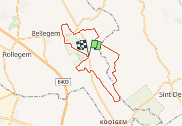
Randonnée A pied de 13,4 km à découvrir à Flandre, Flandre-Occidentale, Courtrai. Cette randonnée est proposée par SityTrail - itinéraires balisés pédestres.
Description
In het landelijke Bellegem wandel je tussen Leie en Schelde in een ruraal en golvend gebied.
Localisation
Pays :
Belgique
Région :
Flandre
Département/Province :
Flandre-Occidentale
Commune :
Courtrai
Localité :
Unknown
Départ:(Dec)
Départ:(UTM)
521839 ; 5624083 (31U) N.
Commentaires
Randonnées à proximité
![Randonnée Marche Zwevegem - sint petersburg - Photo](https://media.geolcdn.com/t/375/260/ext.jpg?maxdim=2&url=https%3A%2F%2Fstatic1.geolcdn.com%2Fsiteimages%2Fupload%2Ffiles%2F1553511878bg_sport_marche.png)
![Marche Marche](https://static1.geolcdn.com/sitytour/trail-icons/101.png)
sint petersburg
Marche
Très facile
(1)
Zwevegem,
Flandre,
Flandre-Occidentale,
Belgique
![](/images/other/stat-length.png)
6,7 km | 7,6 km-effort
1h 14min
![](https://static1.geolcdn.com/siteimages/upload/files/16400158638029165_repeat_loop_refresh_sync_direction_icon.png)
Oui
![Randonnée Marche Zwevegem - Sint denijs 17 Km - Photo](https://media.geolcdn.com/t/375/260/627a45ec-0584-476c-b3d1-3be059107ecf.jpg&format=jpg&maxdim=2)
![Marche Marche](https://static1.geolcdn.com/sitytour/trail-icons/101.png)
Sint denijs 17 Km
Marche
Moyen
Zwevegem,
Flandre,
Flandre-Occidentale,
Belgique
![](/images/other/stat-length.png)
17 km | 19,4 km-effort
3h 59min
![](https://static1.geolcdn.com/siteimages/upload/files/16400158638029165_repeat_loop_refresh_sync_direction_icon.png)
Oui
![Randonnée Vélo Courtrai - Museeuw Classic - Photo](https://media.geolcdn.com/t/375/260/ext.jpg?maxdim=2&url=https%3A%2F%2Fservices.sitytrail.com%2FGeolivesWS%2FDownloadMedia.ashx%3FTrailID%3D67845%26Media%3D83e5e1bdc2230de4198fa2aa4f2f4658_dd21e57044f662b98c20e8d0717d3b3c39a4d064.jpg)
![Vélo Vélo](https://static1.geolcdn.com/sitytour/trail-icons/200.png)
Museeuw Classic
Vélo
Moyen
Courtrai,
Flandre,
Flandre-Occidentale,
Belgique
![](/images/other/stat-length.png)
57 km | 62 km-effort
Inconnu
![](https://static1.geolcdn.com/siteimages/upload/files/16400158638029165_repeat_loop_refresh_sync_direction_icon.png)
Oui
![Randonnée Marche Zwevegem - Zwevegem et les rives de l'Escaut - Photo](https://media.geolcdn.com/t/375/260/4db05c32-6683-4427-91ed-d6044cfeca46.jpg&format=jpg&maxdim=2)
![Marche Marche](https://static1.geolcdn.com/sitytour/trail-icons/101.png)
Zwevegem et les rives de l'Escaut
Marche
Moyen
Zwevegem,
Flandre,
Flandre-Occidentale,
Belgique
![](/images/other/stat-length.png)
25 km | 28 km-effort
5h 6min
![](https://static1.geolcdn.com/siteimages/upload/files/16400158638029165_repeat_loop_refresh_sync_direction_icon.png)
Oui
![Randonnée Marche Courtrai - bellegem marche - Photo](https://media.geolcdn.com/t/375/260/ext.jpg?maxdim=2&url=https%3A%2F%2Fstatic1.geolcdn.com%2Fsiteimages%2Fupload%2Ffiles%2F1553511878bg_sport_marche.png)
![Marche Marche](https://static1.geolcdn.com/sitytour/trail-icons/101.png)
bellegem marche
Marche
Facile
Courtrai,
Flandre,
Flandre-Occidentale,
Belgique
![](/images/other/stat-length.png)
8,9 km | 10,5 km-effort
1h 58min
![](https://static1.geolcdn.com/siteimages/upload/files/16400158638029165_repeat_loop_refresh_sync_direction_icon.png)
Oui
![Randonnée Vélo de route Mouscron - Mouscron Tournai Mouscron - Photo](https://media.geolcdn.com/t/375/260/ext.jpg?maxdim=2&url=https%3A%2F%2Fstatic1.geolcdn.com%2Fsiteimages%2Fupload%2Ffiles%2F1524743154velo.jpg)
![Vélo de route Vélo de route](https://static1.geolcdn.com/sitytour/trail-icons/201.png)
Mouscron Tournai Mouscron
Vélo de route
Très facile
Mouscron,
Wallonie,
Hainaut,
Belgique
![](/images/other/stat-length.png)
53 km | 57 km-effort
3h 48min
![](https://static1.geolcdn.com/siteimages/upload/files/16400158638029165_repeat_loop_refresh_sync_direction_icon.png)
Oui
![Randonnée Vélo de route Mouscron - Goedendagroute2020 - Photo](https://media.geolcdn.com/t/375/260/ext.jpg?maxdim=2&url=https%3A%2F%2Fstatic1.geolcdn.com%2Fsiteimages%2Fupload%2Ffiles%2F1524743154velo.jpg)
![Vélo de route Vélo de route](https://static1.geolcdn.com/sitytour/trail-icons/201.png)
Goedendagroute2020
Vélo de route
Facile
Mouscron,
Wallonie,
Hainaut,
Belgique
![](/images/other/stat-length.png)
52 km | 58 km-effort
3h 48min
![](https://static1.geolcdn.com/siteimages/upload/files/16400158638029165_repeat_loop_refresh_sync_direction_icon.png)
Oui
![Randonnée Cheval Zwevegem - Moen variatie 01 - Photo](https://media.geolcdn.com/t/375/260/ext.jpg?maxdim=2&url=https%3A%2F%2Fstatic1.geolcdn.com%2Fsiteimages%2Fupload%2Ffiles%2F1524743154cheval.jpg)
![Cheval Cheval](https://static1.geolcdn.com/sitytour/trail-icons/300.png)
Moen variatie 01
Cheval
Facile
Zwevegem,
Flandre,
Flandre-Occidentale,
Belgique
![](/images/other/stat-length.png)
13,2 km | 14,6 km-effort
3h 29min
![](https://static1.geolcdn.com/siteimages/upload/files/16400158638029165_repeat_loop_refresh_sync_direction_icon.png)
Oui
![Randonnée Cheval Zwevegem - Paardenwijding Moen 18/8/19 - Photo](https://media.geolcdn.com/t/375/260/ext.jpg?maxdim=2&url=https%3A%2F%2Fstatic1.geolcdn.com%2Fsiteimages%2Fupload%2Ffiles%2F1524743154cheval.jpg)
![Cheval Cheval](https://static1.geolcdn.com/sitytour/trail-icons/300.png)
Paardenwijding Moen 18/8/19
Cheval
Facile
Zwevegem,
Flandre,
Flandre-Occidentale,
Belgique
![](/images/other/stat-length.png)
13,2 km | 14,6 km-effort
3h 29min
![](https://static1.geolcdn.com/siteimages/upload/files/16400158638029165_repeat_loop_refresh_sync_direction_icon.png)
Oui