![](/images/other/stat-length.png)
![Randonnée Marche Monthermé - Woiries 15 km - Photo](https://media.geolcdn.com/t/1900/400/ext.pjpeg?maxdim=2&url=https%3A%2F%2Fstatic1.geolcdn.com%2Fsiteimages%2Fupload%2Ffiles%2F1553511878bg_sport_marche.png)
Woiries 15 km
rvapeldo
Utilisateur GUIDE
![Longueur](/images/other/stat-length.png)
Longueur
15,3 km
![Altitude max](https://static1.geolcdn.com/siteimages/upload/files/1508320355ic_sort_altitude_max_24dp.png)
Altitude max
423 m
![Dénivelé positif](https://static1.geolcdn.com/siteimages/upload/files/1508320355ic_sort_den_pos_24dp.png)
Dénivelé positif
851 m
![Km-Effort](/images/other/stat-length.png)
Km-Effort
27 km
![Altitude min](https://static1.geolcdn.com/siteimages/upload/files/1508320355ic_sort_altitude_min_24dp.png)
Altitude min
168 m
![Dénivelé négatif](https://static1.geolcdn.com/siteimages/upload/files/1508320355ic_sort_den_neg_24dp.png)
Dénivelé négatif
851 m
![Boucle](https://static1.geolcdn.com/siteimages/upload/files/16400158638029165_repeat_loop_refresh_sync_direction_icon.png)
Boucle
Oui
Date de création :
2018-10-06 08:31:13.619
Dernière modification :
2018-10-06 08:31:13.671
![Marche](https://static1.geolcdn.com/sitytour/trail-icons/101.png)
5h21
Difficulté : Moyen
![Scannez ce code QR pour ouvrir la randonnée dans l'application SityTrail](https://capi.geolives.com/qq0zvz2zws4bq2lad0pu/sitytour/trails/308306/qr.png?size=200)
Application GPS de randonnée GRATUITE
À propos
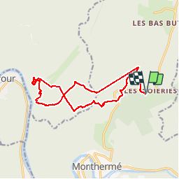
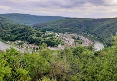
Randonnée Marche de 15,3 km à découvrir à Grand Est, Ardennes, Monthermé. Cette randonnée est proposée par rvapeldo.
Description
trajet un peu rugueux près de la Meuse (ascension vers un maginfique point de vue, au-dessus d'une brèche et tunnel des carriers). Attention, le gps a déconnecté et il y a des lignes droites (le chemin à suivre est assez clair sur la carte).
Localisation
Pays :
France
Région :
Grand Est
Département/Province :
Ardennes
Commune :
Monthermé
Localité :
Unknown
Départ:(Dec)
Départ:(UTM)
626620 ; 5529825 (31U) N.
Commentaires
Randonnées à proximité
![Randonnée Marche Monthermé - De Monthermé à Bogny sur Meuse par les sentiers de crêtes - Photo](https://media.geolcdn.com/t/375/260/ext.jpg?maxdim=2&url=https%3A%2F%2Fservices.sitytrail.com%2FGeolivesWS%2FDownloadMedia.ashx%3FTrailID%3D109030%26Media%3D2990_6.jpg)
![Marche Marche](https://static1.geolcdn.com/sitytour/trail-icons/101.png)
De Monthermé à Bogny sur Meuse par les sentiers de crêtes
Marche
Difficile
(2)
Monthermé,
Grand Est,
Ardennes,
France
![](/images/other/stat-length.png)
14,6 km | 23 km-effort
5h 0min
![](https://static1.geolcdn.com/siteimages/upload/files/16400158638029165_repeat_loop_refresh_sync_direction_icon.png)
Oui
![Randonnée Marche Thilay - monthermé - tour du milénaire (2 jours) - Photo](https://media.geolcdn.com/t/375/260/ext.jpg?maxdim=2&url=https%3A%2F%2Fstatic1.geolcdn.com%2Fsiteimages%2Fupload%2Ffiles%2F1553511878bg_sport_marche.png)
![Marche Marche](https://static1.geolcdn.com/sitytour/trail-icons/101.png)
monthermé - tour du milénaire (2 jours)
Marche
Moyen
(1)
Thilay,
Grand Est,
Ardennes,
France
![](/images/other/stat-length.png)
40 km | 59 km-effort
11h 59min
![](https://static1.geolcdn.com/siteimages/upload/files/16400158638029165_repeat_loop_refresh_sync_direction_icon.png)
Oui
![Randonnée Marche Revin - Laifour-Montherme - Photo](https://media.geolcdn.com/t/375/260/ext.jpg?maxdim=2&url=https%3A%2F%2Fstatic1.geolcdn.com%2Fsiteimages%2Fupload%2Ffiles%2F1553511878bg_sport_marche.png)
![Marche Marche](https://static1.geolcdn.com/sitytour/trail-icons/101.png)
Laifour-Montherme
Marche
Difficile
(1)
Revin,
Grand Est,
Ardennes,
France
![](/images/other/stat-length.png)
21 km | 30 km-effort
8h 8min
![](https://static1.geolcdn.com/siteimages/upload/files/16400158638029165_repeat_loop_refresh_sync_direction_icon.png)
Non
![Randonnée Marche Monthermé - La roche 7H Monthermé - Photo](https://media.geolcdn.com/t/375/260/9f5bae53-ca7e-45f9-9b5d-eda45fb0ca79.jpg&format=jpg&maxdim=2)
![Marche Marche](https://static1.geolcdn.com/sitytour/trail-icons/101.png)
La roche 7H Monthermé
Marche
Moyen
Monthermé,
Grand Est,
Ardennes,
France
![](/images/other/stat-length.png)
5,9 km | 9 km-effort
2h 24min
![](https://static1.geolcdn.com/siteimages/upload/files/16400158638029165_repeat_loop_refresh_sync_direction_icon.png)
Oui
![Randonnée Marche Monthermé - les woiries mercredi - Photo](https://media.geolcdn.com/t/375/260/d0196d84-41f0-4a44-947d-440912977a47.jpg&format=jpg&maxdim=2)
![Marche Marche](https://static1.geolcdn.com/sitytour/trail-icons/101.png)
les woiries mercredi
Marche
Moyen
Monthermé,
Grand Est,
Ardennes,
France
![](/images/other/stat-length.png)
9,6 km | 12,7 km-effort
3h 37min
![](https://static1.geolcdn.com/siteimages/upload/files/16400158638029165_repeat_loop_refresh_sync_direction_icon.png)
Non
![Randonnée Marche Monthermé - Monthermé 22,7 km tour des rochers - Photo](https://media.geolcdn.com/t/375/260/6faf8d21-8c16-4737-b87b-be715fc8c814.jpg&format=jpg&maxdim=2)
![Marche Marche](https://static1.geolcdn.com/sitytour/trail-icons/101.png)
Monthermé 22,7 km tour des rochers
Marche
Difficile
Monthermé,
Grand Est,
Ardennes,
France
![](/images/other/stat-length.png)
23 km | 36 km-effort
8h 20min
![](https://static1.geolcdn.com/siteimages/upload/files/16400158638029165_repeat_loop_refresh_sync_direction_icon.png)
Oui
![Randonnée Marche Monthermé - Monthermé - Photo](https://media.geolcdn.com/t/375/260/1167704e-b918-4908-a8da-997965903325.jpg&format=jpg&maxdim=2)
![Marche Marche](https://static1.geolcdn.com/sitytour/trail-icons/101.png)
![Randonnée Marche Monthermé - AUTOUR DE MONTHERMÉ, la boucle de la Meuse - Photo](https://media.geolcdn.com/t/375/260/7078bc98-043e-41d8-8080-5c4275522860.jpg&format=jpg&maxdim=2)
![Marche Marche](https://static1.geolcdn.com/sitytour/trail-icons/101.png)
AUTOUR DE MONTHERMÉ, la boucle de la Meuse
Marche
Très difficile
Monthermé,
Grand Est,
Ardennes,
France
![](/images/other/stat-length.png)
14,9 km | 24 km-effort
5h 5min
![](https://static1.geolcdn.com/siteimages/upload/files/16400158638029165_repeat_loop_refresh_sync_direction_icon.png)
Oui
![Randonnée Marche Thilay - roc la tour - Photo](https://media.geolcdn.com/t/375/260/ext.jpg?maxdim=2&url=https%3A%2F%2Fstatic1.geolcdn.com%2Fsiteimages%2Fupload%2Ffiles%2F1553511878bg_sport_marche.png)
![Marche Marche](https://static1.geolcdn.com/sitytour/trail-icons/101.png)
roc la tour
Marche
Facile
(1)
Thilay,
Grand Est,
Ardennes,
France
![](/images/other/stat-length.png)
9,6 km | 12,1 km-effort
2h 25min
![](https://static1.geolcdn.com/siteimages/upload/files/16400158638029165_repeat_loop_refresh_sync_direction_icon.png)
Oui