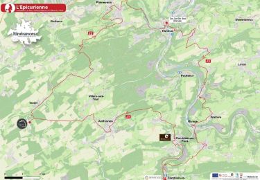
![](/images/other/stat-length.png)
![Randonnée A pied Ouffet - Ouffet - Balade de l'Herberin N°6 - Photo](https://media.geolcdn.com/t/1900/400/ext.pjpeg?maxdim=2&url=https%3A%2F%2Fpivotmedia.tourismewallonie.be%2FANX-0W-00Y1-000O%2FANX-0W-00Y1-000O.jpg)
Ouffet - Balade de l'Herberin N°6
Commissariat général au Tourisme
Randonnées du CGT GUIDE+
![Longueur](/images/other/stat-length.png)
![Altitude max](https://static1.geolcdn.com/siteimages/upload/files/1508320355ic_sort_altitude_max_24dp.png)
![Dénivelé positif](https://static1.geolcdn.com/siteimages/upload/files/1508320355ic_sort_den_pos_24dp.png)
![Km-Effort](/images/other/stat-length.png)
![Altitude min](https://static1.geolcdn.com/siteimages/upload/files/1508320355ic_sort_altitude_min_24dp.png)
![Dénivelé négatif](https://static1.geolcdn.com/siteimages/upload/files/1508320355ic_sort_den_neg_24dp.png)
![Boucle](https://static1.geolcdn.com/siteimages/upload/files/16400158638029165_repeat_loop_refresh_sync_direction_icon.png)
![A pied](https://static1.geolcdn.com/sitytour/trail-icons/100.png)
2h44
Difficulté : Facile
![V.T.T.](https://static1.geolcdn.com/sitytour/trail-icons/202.png)
50m
Difficulté : Facile
![Cheval](https://static1.geolcdn.com/sitytour/trail-icons/300.png)
--
Difficulté : Inconnu
![Scannez ce code QR pour ouvrir la randonnée dans l'application SityTrail](https://capi.geolives.com/qq0zvz2zws4bq2lad0pu/sitytour/trails/3081502/qr.png?size=200)
Application GPS de randonnée GRATUITE
À propos
Randonnée A pied de 10 km à découvrir à Wallonie, Liège, Ouffet. Cette randonnée est proposée par Commissariat général au Tourisme.
Description
Randonnée créée par Ourthe Vesdre Amblève.
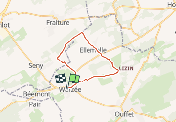
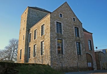
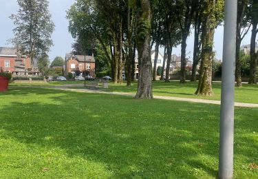
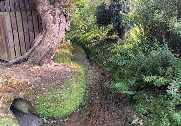
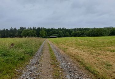
De l’étang d’Ellemelle, le chemin «Derrière la Ville» rendez-vous vers les champs et le magnifique bois de l’Herberin vers Tinlot puis le village de Warzée. Ensuite, il se fraye un passage à travers de nombreuses pâtures vers Lizin. Cette ancienne seigneurie est un intéressant hameau où se trouvent un donjon du 13e s. et deux vastes exploitations agricoles : la Maison forte et la Ferme des Sarrasins. Ellemelle, paroisse citée dès 1005, est un village reconnu pour son patrimoine architectural typique grâce à son bâti de grès à préserver. De grosses fermes du 17e s. témoignent d’un passé agricole encore bien présent actuellement. Son église du 18e s. érigée sur une bute, au centre du village, semble veiller sur ses habitants. Elle est flanquée d’un joli cimetière emmuraillé et est uniquement entourée d’anciennes constructions dont certaines font l’objet de belles reconversions.
Site web: https://ovatourisme.be/details/ITB-0W-000PCC&type=8/
Localisation
Commentaires
Randonnées à proximité
![Marche Marche](https://static1.geolcdn.com/sitytour/trail-icons/101.png)
![Randonnée Marche Ouffet - ouffet fermes ac + - Photo](https://media.geolcdn.com/t/375/260/fd6ab0a5-da2e-4ec4-9fa1-96c42c21280a.jpg&format=jpg&maxdim=2)
![Marche Marche](https://static1.geolcdn.com/sitytour/trail-icons/101.png)
Marche
![](/images/other/stat-length.png)
![](https://static1.geolcdn.com/siteimages/upload/files/16400158638029165_repeat_loop_refresh_sync_direction_icon.png)
![Randonnée A pied Ouffet - 2. Balade des Loups - Photo](https://media.geolcdn.com/t/375/260/d04b3141-28f4-49cc-8744-40be9de688be.jpeg&format=jpg&maxdim=2)
![A pied A pied](https://static1.geolcdn.com/sitytour/trail-icons/100.png)
A pied
![](/images/other/stat-length.png)
![](https://static1.geolcdn.com/siteimages/upload/files/16400158638029165_repeat_loop_refresh_sync_direction_icon.png)
![Randonnée Marche Tinlot - Marche ADEPS Fraiture 2025 15 km - Photo](https://media.geolcdn.com/t/375/260/6307e478-66da-4ab8-bee0-3294e5ab626f.jpg&format=jpg&maxdim=2)
![Marche Marche](https://static1.geolcdn.com/sitytour/trail-icons/101.png)
Marche
![](/images/other/stat-length.png)
![](https://static1.geolcdn.com/siteimages/upload/files/16400158638029165_repeat_loop_refresh_sync_direction_icon.png)
![Randonnée Vélo électrique Ouffet - Ouffet 55 Km - Photo](https://media.geolcdn.com/t/375/260/f1bebc07-0da7-426d-a57a-4c1a3d2ad449.jpg&format=jpg&maxdim=2)
![Vélo électrique Vélo électrique](https://static1.geolcdn.com/sitytour/trail-icons/205.png)
Vélo électrique
![](/images/other/stat-length.png)
![](https://static1.geolcdn.com/siteimages/upload/files/16400158638029165_repeat_loop_refresh_sync_direction_icon.png)
![Randonnée Marche Ouffet - adeps 10km ellemelle - Photo](https://media.geolcdn.com/t/375/260/0162b620-5239-4077-a394-264c02964986.jpg&format=jpg&maxdim=2)
![Marche Marche](https://static1.geolcdn.com/sitytour/trail-icons/101.png)
Marche
![](/images/other/stat-length.png)
![](https://static1.geolcdn.com/siteimages/upload/files/16400158638029165_repeat_loop_refresh_sync_direction_icon.png)
![Randonnée Marche Ouffet - Marche ADEPS Ouffet 2024 - Photo](https://media.geolcdn.com/t/375/260/cea0fd76-6158-4ef7-8a14-73feb82a4ae7.jpg&format=jpg&maxdim=2)
![Marche Marche](https://static1.geolcdn.com/sitytour/trail-icons/101.png)
Marche
![](/images/other/stat-length.png)
![](https://static1.geolcdn.com/siteimages/upload/files/16400158638029165_repeat_loop_refresh_sync_direction_icon.png)
![Randonnée Marche Anthisnes - L'Epicurienne - Etape 2 - Photo](https://media.geolcdn.com/t/375/260/d9ba0971-1545-4ed2-b270-5f7883d00bd4.jpg&format=jpg&maxdim=2)
![Marche Marche](https://static1.geolcdn.com/sitytour/trail-icons/101.png)
Marche
![](/images/other/stat-length.png)
![](https://static1.geolcdn.com/siteimages/upload/files/16400158638029165_repeat_loop_refresh_sync_direction_icon.png)
![Randonnée Marche Durbuy - Marche ADEPS Jenneret - Photo](https://media.geolcdn.com/t/375/260/c8d0ebda-9eda-4b23-acb1-ba0ae9c6846d.jpg&format=jpg&maxdim=2)
![Marche Marche](https://static1.geolcdn.com/sitytour/trail-icons/101.png)
Marche
![](/images/other/stat-length.png)
![](https://static1.geolcdn.com/siteimages/upload/files/16400158638029165_repeat_loop_refresh_sync_direction_icon.png)