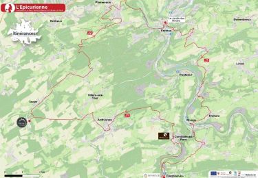
![](/images/other/stat-length.png)
![Randonnée A pied Ouffet - Ouffet - Balade de Béemont N°5 - Photo](https://media.geolcdn.com/t/1900/400/ext.pjpeg?maxdim=2&url=https%3A%2F%2Fpivotmedia.tourismewallonie.be%2FANX-0W-01NQ-0001%2FANX-0W-01NQ-0001.jpg)
Ouffet - Balade de Béemont N°5
Commissariat général au Tourisme
Randonnées du CGT GUIDE+
![Longueur](/images/other/stat-length.png)
![Altitude max](https://static1.geolcdn.com/siteimages/upload/files/1508320355ic_sort_altitude_max_24dp.png)
![Dénivelé positif](https://static1.geolcdn.com/siteimages/upload/files/1508320355ic_sort_den_pos_24dp.png)
![Km-Effort](/images/other/stat-length.png)
![Altitude min](https://static1.geolcdn.com/siteimages/upload/files/1508320355ic_sort_altitude_min_24dp.png)
![Dénivelé négatif](https://static1.geolcdn.com/siteimages/upload/files/1508320355ic_sort_den_neg_24dp.png)
![Boucle](https://static1.geolcdn.com/siteimages/upload/files/16400158638029165_repeat_loop_refresh_sync_direction_icon.png)
![A pied](https://static1.geolcdn.com/sitytour/trail-icons/100.png)
2h17
Difficulté : Facile
![V.T.T.](https://static1.geolcdn.com/sitytour/trail-icons/202.png)
41m
Difficulté : Facile
![Cheval](https://static1.geolcdn.com/sitytour/trail-icons/300.png)
--
Difficulté : Inconnu
![Scannez ce code QR pour ouvrir la randonnée dans l'application SityTrail](https://capi.geolives.com/qq0zvz2zws4bq2lad0pu/sitytour/trails/3081501/qr.png?size=200)
Application GPS de randonnée GRATUITE
À propos
Randonnée A pied de 8,8 km à découvrir à Wallonie, Liège, Ouffet. Cette randonnée est proposée par Commissariat général au Tourisme.
Description
Randonnée créée par Ourthe Vesdre Amblève.
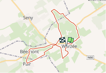
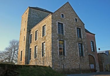
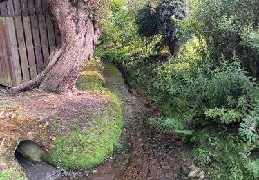
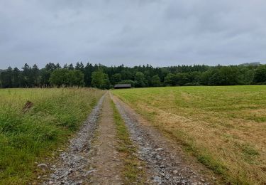
Le point de ralliement se situe à Warzée au niveau du terrain Multisports près de l’école. Deux boucles extérieures vous mèneront à travers champs et prairies vers les entités de Pair et Tinlot. Au niveau de la grotte à Beemont, permettez-vous un petit détour vers le « Chemin de Messe » afin d’y admirer la « Pierre au sacrement » monument classé. De retour sur votre itinéraire, à quelques enjambées, vous admirerez le château datant du 18e siècle et son exploitation agricole en quadrilatère. La balade se terminera par la découverte de quelques belles bâtisses ainsi que l’église St Martin.
Site web: https://ovatourisme.be/details/ITB-0W-000PCA&type=8/
Localisation
Commentaires
Randonnées à proximité
![Marche Marche](https://static1.geolcdn.com/sitytour/trail-icons/101.png)
![Randonnée Marche Ouffet - ouffet fermes ac + - Photo](https://media.geolcdn.com/t/375/260/fd6ab0a5-da2e-4ec4-9fa1-96c42c21280a.jpg&format=jpg&maxdim=2)
![Marche Marche](https://static1.geolcdn.com/sitytour/trail-icons/101.png)
Marche
![](/images/other/stat-length.png)
![](https://static1.geolcdn.com/siteimages/upload/files/16400158638029165_repeat_loop_refresh_sync_direction_icon.png)
![Randonnée A pied Ouffet - 2. Balade des Loups - Photo](https://media.geolcdn.com/t/375/260/d04b3141-28f4-49cc-8744-40be9de688be.jpeg&format=jpg&maxdim=2)
![A pied A pied](https://static1.geolcdn.com/sitytour/trail-icons/100.png)
A pied
![](/images/other/stat-length.png)
![](https://static1.geolcdn.com/siteimages/upload/files/16400158638029165_repeat_loop_refresh_sync_direction_icon.png)
![Randonnée Marche Tinlot - Marche ADEPS Fraiture 2025 15 km - Photo](https://media.geolcdn.com/t/375/260/6307e478-66da-4ab8-bee0-3294e5ab626f.jpg&format=jpg&maxdim=2)
![Marche Marche](https://static1.geolcdn.com/sitytour/trail-icons/101.png)
Marche
![](/images/other/stat-length.png)
![](https://static1.geolcdn.com/siteimages/upload/files/16400158638029165_repeat_loop_refresh_sync_direction_icon.png)
![Randonnée Vélo électrique Ouffet - Ouffet 55 Km - Photo](https://media.geolcdn.com/t/375/260/f1bebc07-0da7-426d-a57a-4c1a3d2ad449.jpg&format=jpg&maxdim=2)
![Vélo électrique Vélo électrique](https://static1.geolcdn.com/sitytour/trail-icons/205.png)
Vélo électrique
![](/images/other/stat-length.png)
![](https://static1.geolcdn.com/siteimages/upload/files/16400158638029165_repeat_loop_refresh_sync_direction_icon.png)
![Randonnée Marche Ouffet - adeps 10km ellemelle - Photo](https://media.geolcdn.com/t/375/260/0162b620-5239-4077-a394-264c02964986.jpg&format=jpg&maxdim=2)
![Marche Marche](https://static1.geolcdn.com/sitytour/trail-icons/101.png)
Marche
![](/images/other/stat-length.png)
![](https://static1.geolcdn.com/siteimages/upload/files/16400158638029165_repeat_loop_refresh_sync_direction_icon.png)
![Randonnée Marche Ouffet - Marche ADEPS Ouffet 2024 - Photo](https://media.geolcdn.com/t/375/260/cea0fd76-6158-4ef7-8a14-73feb82a4ae7.jpg&format=jpg&maxdim=2)
![Marche Marche](https://static1.geolcdn.com/sitytour/trail-icons/101.png)
Marche
![](/images/other/stat-length.png)
![](https://static1.geolcdn.com/siteimages/upload/files/16400158638029165_repeat_loop_refresh_sync_direction_icon.png)
![Randonnée Marche Anthisnes - L'Epicurienne - Etape 2 - Photo](https://media.geolcdn.com/t/375/260/d9ba0971-1545-4ed2-b270-5f7883d00bd4.jpg&format=jpg&maxdim=2)
![Marche Marche](https://static1.geolcdn.com/sitytour/trail-icons/101.png)
Marche
![](/images/other/stat-length.png)
![](https://static1.geolcdn.com/siteimages/upload/files/16400158638029165_repeat_loop_refresh_sync_direction_icon.png)
![Randonnée Marche Durbuy - Marche ADEPS Jenneret - Photo](https://media.geolcdn.com/t/375/260/c8d0ebda-9eda-4b23-acb1-ba0ae9c6846d.jpg&format=jpg&maxdim=2)
![Marche Marche](https://static1.geolcdn.com/sitytour/trail-icons/101.png)
Marche
![](/images/other/stat-length.png)
![](https://static1.geolcdn.com/siteimages/upload/files/16400158638029165_repeat_loop_refresh_sync_direction_icon.png)